Note:
The expiration time in the watch graphic is amended if the watch is
replaced, cancelled or extended.
Note:
Note:
The expiration time in the watch graphic is amended if the watch is
replaced, cancelled or extended.
Note: Click for
Watch Status Reports.
SEL4
URGENT - IMMEDIATE BROADCAST REQUESTED
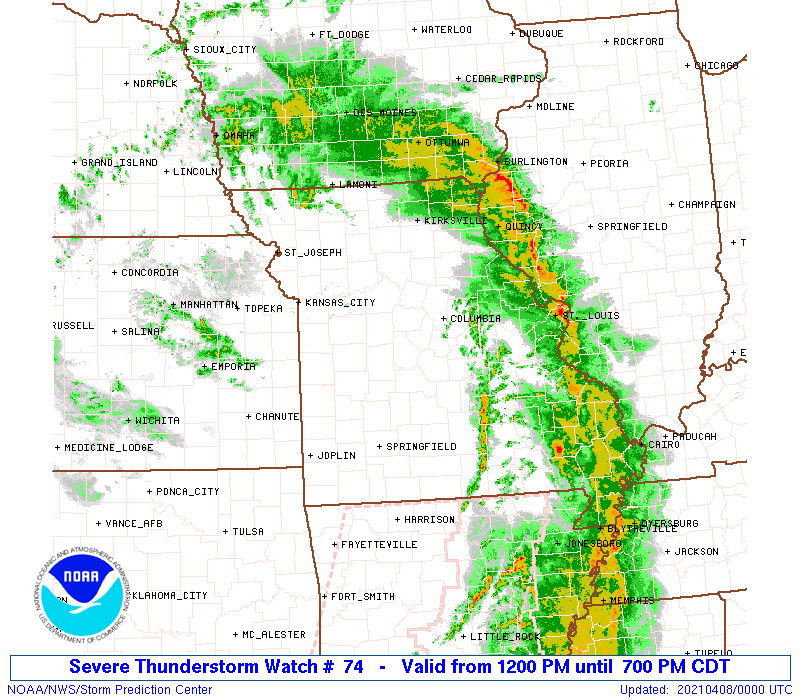
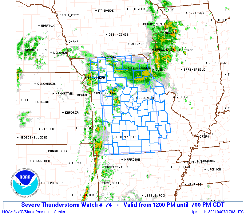
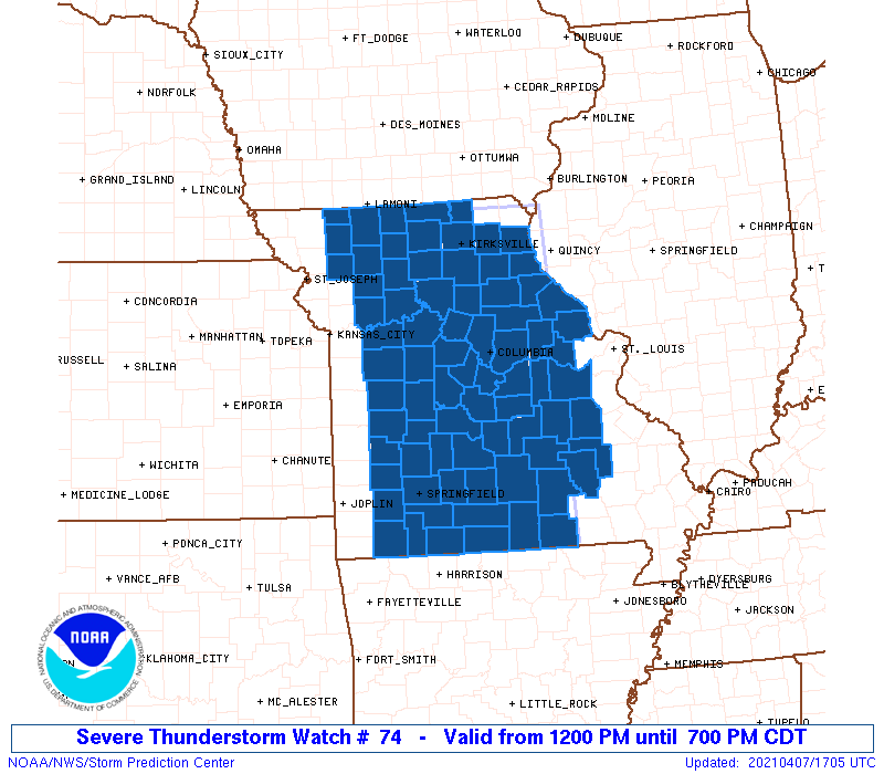
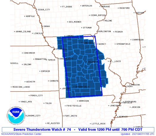
Severe Thunderstorm Watch Number 74
NWS Storm Prediction Center Norman OK
1200 PM CDT Wed Apr 7 2021
The NWS Storm Prediction Center has issued a
* Severe Thunderstorm Watch for portions of
Much of Missouri
* Effective this Wednesday afternoon and evening from NOON until
700 PM CDT.
* Primary threats include...
Scattered damaging wind gusts to 70 mph possible
Scattered large hail events to 1.5 inches in diameter possible
A tornado or two possible
SUMMARY...Thunderstorms are expected to intensify this afternoon
over western Missouri and track northeastward across the watch area.
A few severe storms are anticipated, with the possiblity of large
hail, damaging winds. A tornado or two cannot be ruled out.
The severe thunderstorm watch area is approximately along and 75
statute miles east and west of a line from 30 miles north northwest
of Kirksville MO to 35 miles west southwest of West Plains MO. For a
complete depiction of the watch see the associated watch outline
update (WOUS64 KWNS WOU4).
PRECAUTIONARY/PREPAREDNESS ACTIONS...
REMEMBER...A Severe Thunderstorm Watch means conditions are
favorable for severe thunderstorms in and close to the watch area.
Persons in these areas should be on the lookout for threatening
weather conditions and listen for later statements and possible
warnings. Severe thunderstorms can and occasionally do produce
tornadoes.
&&
AVIATION...A few severe thunderstorms with hail surface and aloft to
1.5 inches. Extreme turbulence and surface wind gusts to 60 knots. A
few cumulonimbi with maximum tops to 450. Mean storm motion vector
24030.
...Hart

   SEL4

   URGENT - IMMEDIATE BROADCAST REQUESTED
   Severe Thunderstorm Watch Number 74
   NWS Storm Prediction Center Norman OK
   1200 PM CDT Wed Apr 7 2021

   The NWS Storm Prediction Center has issued a

   * Severe Thunderstorm Watch for portions of
     Much of Missouri

   * Effective this Wednesday afternoon and evening from NOON until
     700 PM CDT.

   * Primary threats include...
     Scattered damaging wind gusts to 70 mph possible
     Scattered large hail events to 1.5 inches in diameter possible
     A tornado or two possible

   SUMMARY...Thunderstorms are expected to intensify this afternoon
   over western Missouri and track northeastward across the watch area.
    A few severe storms are anticipated, with the possiblity of large
   hail, damaging winds.  A tornado or two cannot be ruled out.

   The severe thunderstorm watch area is approximately along and 75
   statute miles east and west of a line from 30 miles north northwest
   of Kirksville MO to 35 miles west southwest of West Plains MO. For a
   complete depiction of the watch see the associated watch outline
   update (WOUS64 KWNS WOU4).

   PRECAUTIONARY/PREPAREDNESS ACTIONS...

   REMEMBER...A Severe Thunderstorm Watch means conditions are
   favorable for severe thunderstorms in and close to the watch area.
   Persons in these areas should be on the lookout for threatening
   weather conditions and listen for later statements and possible
   warnings. Severe thunderstorms can and occasionally do produce
   tornadoes.

   &&

   AVIATION...A few severe thunderstorms with hail surface and aloft to
   1.5 inches. Extreme turbulence and surface wind gusts to 60 knots. A
   few cumulonimbi with maximum tops to 450. Mean storm motion vector
   24030.

   ...Hart
 Note:
The Aviation Watch (SAW) product is an approximation to the watch area.
The actual watch is depicted by the shaded areas.
Note:
The Aviation Watch (SAW) product is an approximation to the watch area.
The actual watch is depicted by the shaded areas.
   SAW4
   WW 74 SEVERE TSTM MO 071700Z - 080000Z
   AXIS..75 STATUTE MILES EAST AND WEST OF LINE..
   30NNW IRK/KIRKSVILLE MO/ - 35WSW UNO/WEST PLAINS MO/
   ..AVIATION COORDS.. 65NM E/W /23NNW IRK - 64SE SGF/
   HAIL SURFACE AND ALOFT..1.5 INCHES. WIND GUSTS..60 KNOTS.
   MAX TOPS TO 450. MEAN STORM MOTION VECTOR 24030.

   LAT...LON 40499134 36559110 36559380 40499420

   THIS IS AN APPROXIMATION TO THE WATCH AREA.  FOR A
   COMPLETE DEPICTION OF THE WATCH SEE WOUS64 KWNS
   FOR WOU4.
Watch 74 Status Report Messages:
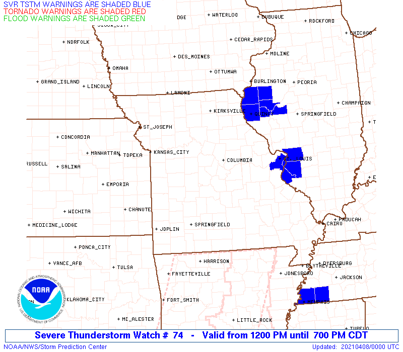
STATUS REPORT #6 ON WW 74

VALID 072330Z - 080040Z

SEVERE WEATHER THREAT CONTINUES RIGHT OF A LINE FROM 10 NE FLP TO
30 NW UNO TO 10 ENE JEF TO 30 NW ALN.

..WENDT..04/07/21

ATTN...WFO...EAX...LSX...SGF...

&&

STATUS REPORT FOR WS 74

SEVERE WEATHER THREAT CONTINUES FOR THE FOLLOWING AREAS

MOC055-065-071-073-091-093-099-123-125-149-151-161-179-183-186-
187-189-203-215-221-510-080040-

MO
.    MISSOURI COUNTIES INCLUDED ARE

CRAWFORD	     DENT		 FRANKLIN
GASCONADE	     HOWELL		 IRON
JEFFERSON	     MADISON		 MARIES
OREGON		     OSAGE		 PHELPS
REYNOLDS	     ST. CHARLES	 STE. GENEVIEVE
ST. FRANCOIS	     ST. LOUIS		 SHANNON
TEXAS		     WASHINGTON


MISSOURI INDEPENDENT CITIES INCLUDED ARE

ST. LOUIS CITY
$$


THE WATCH STATUS MESSAGE IS FOR GUIDANCE PURPOSES ONLY.  PLEASE
REFER TO WATCH COUNTY NOTIFICATION STATEMENTS FOR OFFICIAL
INFORMATION ON COUNTIES...INDEPENDENT CITIES AND MARINE ZONES
CLEARED FROM SEVERE THUNDERSTORM AND TORNADO WATCHES.
$$

STATUS REPORT #5 ON WW 74

VALID 072245Z - 072340Z

SEVERE WEATHER THREAT CONTINUES RIGHT OF A LINE FROM 25 N FLP TO
20 S JEF TO 25 NE COU TO 40 SE IRK TO 30 SSW OTM.

..WENDT..04/07/21

ATTN...WFO...EAX...LSX...SGF...

&&

STATUS REPORT FOR WS 74

SEVERE WEATHER THREAT CONTINUES FOR THE FOLLOWING AREAS

MOC007-027-055-065-071-073-091-093-099-103-111-113-123-125-127-
139-149-151-153-161-163-169-173-179-183-186-187-189-203-215-219-
221-510-072340-

MO
.    MISSOURI COUNTIES INCLUDED ARE

AUDRAIN 	     CALLAWAY		 CRAWFORD
DENT		     FRANKLIN		 GASCONADE
HOWELL		     IRON		 JEFFERSON
KNOX		     LEWIS		 LINCOLN
MADISON 	     MARIES		 MARION
MONTGOMERY	     OREGON		 OSAGE
OZARK		     PHELPS		 PIKE
PULASKI 	     RALLS		 REYNOLDS
ST. CHARLES	     STE. GENEVIEVE	 ST. FRANCOIS
ST. LOUIS	     SHANNON		 TEXAS
WARREN		     WASHINGTON


MISSOURI INDEPENDENT CITIES INCLUDED ARE

ST. LOUIS CITY
$$


THE WATCH STATUS MESSAGE IS FOR GUIDANCE PURPOSES ONLY.  PLEASE
REFER TO WATCH COUNTY NOTIFICATION STATEMENTS FOR OFFICIAL
INFORMATION ON COUNTIES...INDEPENDENT CITIES AND MARINE ZONES
CLEARED FROM SEVERE THUNDERSTORM AND TORNADO WATCHES.
$$

STATUS REPORT #4 ON WW 74

VALID 072135Z - 072240Z

SEVERE WEATHER THREAT CONTINUES RIGHT OF A LINE FROM 15 NE HRO TO
35 ESE SGF TO 30 WNW TBN TO 30 W COU TO 25 E CDJ TO 5 NNW LWD.

..WENDT..04/07/21

ATTN...WFO...EAX...LSX...SGF...

&&

STATUS REPORT FOR WS 74

SEVERE WEATHER THREAT CONTINUES FOR THE FOLLOWING AREAS

MOC001-007-019-027-041-051-055-065-067-071-073-089-091-093-103-
105-111-113-115-121-125-127-129-131-135-137-139-149-151-153-161-
163-169-171-173-175-179-197-203-205-211-215-219-221-229-
072240-

MO
.    MISSOURI COUNTIES INCLUDED ARE

ADAIR		     AUDRAIN		 BOONE
CALLAWAY	     CHARITON		 COLE
CRAWFORD	     DENT		 DOUGLAS
FRANKLIN	     GASCONADE		 HOWARD
HOWELL		     IRON		 KNOX
LACLEDE 	     LEWIS		 LINCOLN
LINN		     MACON		 MARIES
MARION		     MERCER		 MILLER
MONITEAU	     MONROE		 MONTGOMERY
OREGON		     OSAGE		 OZARK
PHELPS		     PIKE		 PULASKI
PUTNAM		     RALLS		 RANDOLPH
REYNOLDS	     SCHUYLER		 SHANNON
SHELBY		     SULLIVAN		 TEXAS
WARREN		     WASHINGTON 	 WRIGHT
$$


THE WATCH STATUS MESSAGE IS FOR GUIDANCE PURPOSES ONLY.  PLEASE
REFER TO WATCH COUNTY NOTIFICATION STATEMENTS FOR OFFICIAL
INFORMATION ON COUNTIES...INDEPENDENT CITIES AND MARINE ZONES
CLEARED FROM SEVERE THUNDERSTORM AND TORNADO WATCHES.
$$

STATUS REPORT #3 ON WW 74

VALID 072020Z - 072140Z

SEVERE WEATHER THREAT CONTINUES RIGHT OF A LINE FROM 25 NNE HRO
TO 35 NNE SGF TO 25 NE SZL TO 15 WSW LWD.

..KERR..04/07/21

ATTN...WFO...EAX...LSX...SGF...

&&

STATUS REPORT FOR WS 74

SEVERE WEATHER THREAT CONTINUES FOR THE FOLLOWING AREAS

MOC001-007-019-027-029-033-041-043-051-053-055-059-065-067-071-
073-079-081-089-091-093-103-105-111-113-115-117-121-125-127-129-
131-135-137-139-141-149-151-153-159-161-163-169-171-173-175-179-
195-197-203-205-211-213-215-219-221-225-229-072140-

MO
.    MISSOURI COUNTIES INCLUDED ARE

ADAIR		     AUDRAIN		 BOONE
CALLAWAY	     CAMDEN		 CARROLL
CHARITON	     CHRISTIAN		 COLE
COOPER		     CRAWFORD		 DALLAS
DENT		     DOUGLAS		 FRANKLIN
GASCONADE	     GRUNDY		 HARRISON
HOWARD		     HOWELL		 IRON
KNOX		     LACLEDE		 LEWIS
LINCOLN 	     LINN		 LIVINGSTON
MACON		     MARIES		 MARION
MERCER		     MILLER		 MONITEAU
MONROE		     MONTGOMERY 	 MORGAN
OREGON		     OSAGE		 OZARK
PETTIS		     PHELPS		 PIKE
PULASKI 	     PUTNAM		 RALLS
RANDOLPH	     REYNOLDS		 SALINE
SCHUYLER	     SHANNON		 SHELBY
SULLIVAN	     TANEY		 TEXAS
WARREN		     WASHINGTON 	 WEBSTER
WRIGHT
$$


THE WATCH STATUS MESSAGE IS FOR GUIDANCE PURPOSES ONLY.  PLEASE
REFER TO WATCH COUNTY NOTIFICATION STATEMENTS FOR OFFICIAL
INFORMATION ON COUNTIES...INDEPENDENT CITIES AND MARINE ZONES
CLEARED FROM SEVERE THUNDERSTORM AND TORNADO WATCHES.
$$

STATUS REPORT #2 ON WW 74

VALID 071930Z - 072040Z

SEVERE WEATHER THREAT CONTINUES RIGHT OF A LINE FROM 20 NNW HRO
TO 35 S SZL TO 10 SW SZL TO 25 WNW SZL.

..KERR..04/07/21

ATTN...WFO...EAX...LSX...SGF...

&&

STATUS REPORT FOR WS 74

SEVERE WEATHER THREAT CONTINUES FOR THE FOLLOWING AREAS

MOC001-007-015-019-025-027-029-033-041-043-051-053-055-059-061-
063-065-067-071-073-075-077-079-081-085-089-091-093-101-103-105-
107-111-113-115-117-121-125-127-129-131-135-137-139-141-149-151-
153-159-161-163-167-169-171-173-175-177-179-195-197-203-205-211-
213-215-219-221-225-227-229-072040-

MO
.    MISSOURI COUNTIES INCLUDED ARE

ADAIR		     AUDRAIN		 BENTON
BOONE		     CALDWELL		 CALLAWAY
CAMDEN		     CARROLL		 CHARITON
CHRISTIAN	     COLE		 COOPER
CRAWFORD	     DALLAS		 DAVIESS
DEKALB		     DENT		 DOUGLAS
FRANKLIN	     GASCONADE		 GENTRY
GREENE		     GRUNDY		 HARRISON
HICKORY 	     HOWARD		 HOWELL
IRON		     JOHNSON		 KNOX
LACLEDE 	     LAFAYETTE		 LEWIS
LINCOLN 	     LINN		 LIVINGSTON
MACON		     MARIES		 MARION
MERCER		     MILLER		 MONITEAU
MONROE		     MONTGOMERY 	 MORGAN
OREGON		     OSAGE		 OZARK
PETTIS		     PHELPS		 PIKE
POLK		     PULASKI		 PUTNAM
RALLS		     RANDOLPH		 RAY
REYNOLDS	     SALINE		 SCHUYLER
SHANNON 	     SHELBY		 SULLIVAN
TANEY		     TEXAS		 WARREN
WASHINGTON	     WEBSTER		 WORTH
WRIGHT
$$


THE WATCH STATUS MESSAGE IS FOR GUIDANCE PURPOSES ONLY.  PLEASE
REFER TO WATCH COUNTY NOTIFICATION STATEMENTS FOR OFFICIAL
INFORMATION ON COUNTIES...INDEPENDENT CITIES AND MARINE ZONES
CLEARED FROM SEVERE THUNDERSTORM AND TORNADO WATCHES.
$$

STATUS REPORT #1 ON WW 74

VALID 071845Z - 071940Z

THE SEVERE WEATHER THREAT CONTINUES ACROSS THE ENTIRE WATCH AREA.

..KERR..04/07/21

ATTN...WFO...EAX...LSX...SGF...

&&

STATUS REPORT FOR WS 74

SEVERE WEATHER THREAT CONTINUES FOR THE FOLLOWING AREAS

MOC001-007-009-015-019-025-027-029-033-039-041-043-051-053-055-
057-059-061-063-065-067-071-073-075-077-079-081-083-085-089-091-
093-101-103-105-107-109-111-113-115-117-121-125-127-129-131-135-
137-139-141-149-151-153-159-161-163-167-169-171-173-175-177-179-
185-195-197-203-205-209-211-213-215-219-221-225-227-229-
071940-

MO
.    MISSOURI COUNTIES INCLUDED ARE

ADAIR		     AUDRAIN		 BARRY
BENTON		     BOONE		 CALDWELL
CALLAWAY	     CAMDEN		 CARROLL
CEDAR		     CHARITON		 CHRISTIAN
COLE		     COOPER		 CRAWFORD
DADE		     DALLAS		 DAVIESS
DEKALB		     DENT		 DOUGLAS
FRANKLIN	     GASCONADE		 GENTRY
GREENE		     GRUNDY		 HARRISON
HENRY		     HICKORY		 HOWARD
HOWELL		     IRON		 JOHNSON
KNOX		     LACLEDE		 LAFAYETTE
LAWRENCE	     LEWIS		 LINCOLN
LINN		     LIVINGSTON 	 MACON
MARIES		     MARION		 MERCER
MILLER		     MONITEAU		 MONROE
MONTGOMERY	     MORGAN		 OREGON
OSAGE		     OZARK		 PETTIS
PHELPS		     PIKE		 POLK
PULASKI 	     PUTNAM		 RALLS
RANDOLPH	     RAY		 REYNOLDS
ST. CLAIR	     SALINE		 SCHUYLER
SHANNON 	     SHELBY		 STONE
SULLIVAN	     TANEY		 TEXAS
WARREN		     WASHINGTON 	 WEBSTER
WORTH		     WRIGHT
$$


THE WATCH STATUS MESSAGE IS FOR GUIDANCE PURPOSES ONLY.  PLEASE
REFER TO WATCH COUNTY NOTIFICATION STATEMENTS FOR OFFICIAL
INFORMATION ON COUNTIES...INDEPENDENT CITIES AND MARINE ZONES
CLEARED FROM SEVERE THUNDERSTORM AND TORNADO WATCHES.
$$
Note:
Click for Complete Product Text.
Tornadoes
Probability of 2 or more tornadoes
|
Low (20%)
|
Probability of 1 or more strong (EF2-EF5) tornadoes
|
Low (5%)
|
Wind
Probability of 10 or more severe wind events
|
Mod (50%)
|
Probability of 1 or more wind events > 65 knots
|
Low (20%)
|
Hail
Probability of 10 or more severe hail events
|
Mod (40%)
|
Probability of 1 or more hailstones > 2 inches
|
Low (20%)
|
Combined Severe Hail/Wind
Probability of 6 or more combined severe hail/wind events
|
High (80%)
|
For each watch, probabilities for particular events inside the watch
(listed above in each table) are determined by the issuing forecaster.
The "Low" category contains probability values ranging from less than 2%
to 20% (EF2-EF5 tornadoes), less than 5% to 20% (all other probabilities),
"Moderate" from 30% to 60%, and "High" from 70% to greater than 95%.
High values are bolded and lighter in color to provide awareness of
an increased threat for a particular event.


 @NWSSPC