|
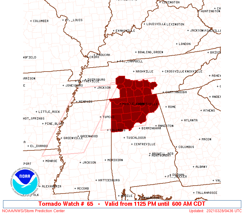
Initial List of Counties in SPC Tornado Watch 65 (WOU)
|
Back to Watch 65
|
 |
   WOUS64 KWNS 280425
   WOU5

   BULLETIN - IMMEDIATE BROADCAST REQUESTED
   TORNADO WATCH OUTLINE UPDATE FOR WT 65
   NWS STORM PREDICTION CENTER NORMAN OK
   1125 PM CDT SAT MAR 27 2021

   TORNADO WATCH 65 IS IN EFFECT UNTIL 600 AM CDT FOR THE
    FOLLOWING LOCATIONS

   ALC009-033-043-049-057-059-071-075-077-079-083-089-093-095-103-
   127-133-281100-
   /O.NEW.KWNS.TO.A.0065.210328T0425Z-210328T1100Z/

   AL
   .    ALABAMA COUNTIES INCLUDED ARE

   BLOUNT               COLBERT             CULLMAN
   DEKALB               FAYETTE             FRANKLIN
   JACKSON              LAMAR               LAUDERDALE
   LAWRENCE             LIMESTONE           MADISON
   MARION               MARSHALL            MORGAN
   WALKER               WINSTON


   TNC003-031-051-055-061-081-099-101-103-117-119-127-281100-
   /O.NEW.KWNS.TO.A.0065.210328T0425Z-210328T1100Z/

   TN
   .    TENNESSEE COUNTIES INCLUDED ARE

   BEDFORD              COFFEE              FRANKLIN
   GILES                GRUNDY              HICKMAN
   LAWRENCE             LEWIS               LINCOLN
   MARSHALL             MAURY               MOORE


   ATTN...WFO...BMX...HUN...OHX...
|
| Aviation Watch (SAW) for WW65 |
|---|
 |
| Note:
The Aviation Watch (SAW) product is an approximation to the watch area.
The actual watch is depicted by the shaded areas. |
   SAW5
   WW 65 TORNADO AL TN 280425Z - 281100Z
   AXIS..70 STATUTE MILES EAST AND WEST OF LINE..
   75N HSV/HUNTSVILLE AL/ - 75S MSL/MUSCLE SHOALS AL/
   ..AVIATION COORDS.. 60NM E/W /25SSW BNA - 36W VUZ/
   HAIL SURFACE AND ALOFT..1 INCH. WIND GUSTS..75 KNOTS.
   MAX TOPS TO 500. MEAN STORM MOTION VECTOR 25050.

   LAT...LON 35738553 33668640 33668884 35738803

   THIS IS AN APPROXIMATION TO THE WATCH AREA.  FOR A
   COMPLETE DEPICTION OF THE WATCH SEE WOUS64 KWNS
   FOR WOU5.
|
|


 @NWSSPC