|
Initial List of Counties in SPC Severe Thunderstorm Watch 48 (WOU)
|
Back to Watch 48
|
 |
WOUS64 KWNS 242155
WOU8
BULLETIN - IMMEDIATE BROADCAST REQUESTED
SEVERE THUNDERSTORM WATCH OUTLINE UPDATE FOR WS 48
NWS STORM PREDICTION CENTER NORMAN OK
500 PM CDT WED MAR 24 2021
SEVERE THUNDERSTORM WATCH 48 IS IN EFFECT UNTIL 1000 PM CDT
FOR THE FOLLOWING LOCATIONS
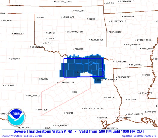
TXC063-085-097-113-119-121-147-159-181-183-223-231-277-343-367-
379-387-397-423-439-449-459-497-499-250300-
/O.NEW.KWNS.SV.A.0048.210324T2200Z-210325T0300Z/
TX
. TEXAS COUNTIES INCLUDED ARE
CAMP COLLIN COOKE
DALLAS DELTA DENTON
FANNIN FRANKLIN GRAYSON
GREGG HOPKINS HUNT
LAMAR MORRIS PARKER
RAINS RED RIVER ROCKWALL
SMITH TARRANT TITUS
UPSHUR WISE WOOD
ATTN...WFO...SHV...FWD...
|
| Aviation Watch (SAW) for WW48 |
|---|
 |
| Note:
The Aviation Watch (SAW) product is an approximation to the watch area.
The actual watch is depicted by the shaded areas. |
   SAW8
   WW 48 SEVERE TSTM TX 242200Z - 250300Z
   AXIS..40 STATUTE MILES NORTH AND SOUTH OF LINE..
   30NW FTW/FORT WORTH TX/ - 50SE PRX/PARIS TX/
   ..AVIATION COORDS.. 35NM N/S /38WNW TTT - 42N GGG/
   HAIL SURFACE AND ALOFT..2 INCHES. WIND GUSTS..60 KNOTS.
   MAX TOPS TO 500. MEAN STORM MOTION VECTOR 22040.

   LAT...LON 33719774 33709484 32549484 32559774

   THIS IS AN APPROXIMATION TO THE WATCH AREA.  FOR A
   COMPLETE DEPICTION OF THE WATCH SEE WOUS64 KWNS
   FOR WOU8.
|
|


 @NWSSPC
