 Note:
The expiration time in the watch graphic is amended if the watch is
replaced, cancelled or extended.
Note:
Note:
The expiration time in the watch graphic is amended if the watch is
replaced, cancelled or extended.
Note: Click for
Watch Status Reports.
SEL5
URGENT - IMMEDIATE BROADCAST REQUESTED
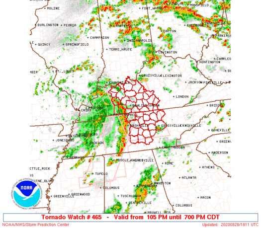
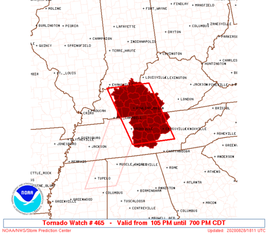
Tornado Watch Number 465
NWS Storm Prediction Center Norman OK
105 PM CDT Fri Aug 28 2020
The NWS Storm Prediction Center has issued a
* Tornado Watch for portions of
Western and central Kentucky
Middle Tennessee
* Effective this Friday afternoon and evening from 105 PM until
700 PM CDT.
* Primary threats include...
A couple tornadoes possible
Scattered damaging wind gusts to 65 mph possible
SUMMARY...A squall line should progress northeast across from
southwest Kentucky and middle Tennessee. Brief tornadoes will remain
possible within it, along with a risk for damaging winds.
The tornado watch area is approximately along and 60 statute miles
east and west of a line from 45 miles southwest of Crossville TN to
35 miles east northeast of Owensboro KY. For a complete depiction of
the watch see the associated watch outline update (WOUS64 KWNS
WOU5).
PRECAUTIONARY/PREPAREDNESS ACTIONS...
REMEMBER...A Tornado Watch means conditions are favorable for
tornadoes and severe thunderstorms in and close to the watch
area. Persons in these areas should be on the lookout for
threatening weather conditions and listen for later statements
and possible warnings.
&&
OTHER WATCH INFORMATION...CONTINUE...WW 463...WW 464...
AVIATION...Tornadoes and a few severe thunderstorms with hail
surface and aloft to 0.5 inches. Extreme turbulence and surface wind
gusts to 55 knots. A few cumulonimbi with maximum tops to 400. Mean
storm motion vector 21035.
...Grams
   SEL5

   URGENT - IMMEDIATE BROADCAST REQUESTED
   Tornado Watch Number 465
   NWS Storm Prediction Center Norman OK
   105 PM CDT Fri Aug 28 2020

   The NWS Storm Prediction Center has issued a

   * Tornado Watch for portions of
     Western and central Kentucky
     Middle Tennessee

   * Effective this Friday afternoon and evening from 105 PM until
     700 PM CDT.

   * Primary threats include...
     A couple tornadoes possible
     Scattered damaging wind gusts to 65 mph possible

   SUMMARY...A squall line should progress northeast across from
   southwest Kentucky and middle Tennessee. Brief tornadoes will remain
   possible within it, along with a risk for damaging winds.

   The tornado watch area is approximately along and 60 statute miles
   east and west of a line from 45 miles southwest of Crossville TN to
   35 miles east northeast of Owensboro KY. For a complete depiction of
   the watch see the associated watch outline update (WOUS64 KWNS
   WOU5).

   PRECAUTIONARY/PREPAREDNESS ACTIONS...

   REMEMBER...A Tornado Watch means conditions are favorable for
   tornadoes and severe thunderstorms in and close to the watch
   area. Persons in these areas should be on the lookout for
   threatening weather conditions and listen for later statements
   and possible warnings.

   &&

   OTHER WATCH INFORMATION...CONTINUE...WW 463...WW 464...

   AVIATION...Tornadoes and a few severe thunderstorms with hail
   surface and aloft to 0.5 inches. Extreme turbulence and surface wind
   gusts to 55 knots. A few cumulonimbi with maximum tops to 400. Mean
   storm motion vector 21035.

   ...Grams
 Note:
The Aviation Watch (SAW) product is an approximation to the watch area.
The actual watch is depicted by the shaded areas.
Note:
The Aviation Watch (SAW) product is an approximation to the watch area.
The actual watch is depicted by the shaded areas.
   SAW5
   WW 465 TORNADO KY TN 281805Z - 290000Z
   AXIS..60 STATUTE MILES EAST AND WEST OF LINE..
   45SW CSV/CROSSVILLE TN/ - 35ENE OWB/OWENSBORO KY/
   ..AVIATION COORDS.. 50NM E/W /40NW GQO - 48WSW IIU/
   HAIL SURFACE AND ALOFT..0.5 INCH. WIND GUSTS..55 KNOTS.
   MAX TOPS TO 400. MEAN STORM MOTION VECTOR 21035.

   LAT...LON 35488671 37918768 37918548 35488458

   THIS IS AN APPROXIMATION TO THE WATCH AREA.  FOR A
   COMPLETE DEPICTION OF THE WATCH SEE WOUS64 KWNS
   FOR WOU5.
Watch 465 Status Report Messages:
STATUS REPORT #2 ON WW 465

VALID 281955Z - 282040Z

SEVERE WEATHER THREAT CONTINUES RIGHT OF A LINE FROM 45 SSE BNA
TO 30 ESE BWG TO 35 NNE BWG TO 20 NE OWB.

..SMITH..08/28/20

ATTN...WFO...LMK...PAH...OHX...

&&

STATUS REPORT FOR WT 465

SEVERE WEATHER THREAT CONTINUES FOR THE FOLLOWING AREAS

KYC001-009-027-053-057-085-087-091-093-099-123-163-169-171-207-
217-282040-

KY
.    KENTUCKY COUNTIES INCLUDED ARE

ADAIR		     BARREN		 BRECKINRIDGE
CLINTON 	     CUMBERLAND 	 GRAYSON
GREEN		     HANCOCK		 HARDIN
HART		     LARUE		 MEADE
METCALFE	     MONROE		 RUSSELL
TAYLOR
$$


TNC003-015-027-031-035-041-049-061-087-111-133-137-141-149-159-
169-175-177-185-189-282040-

TN
.    TENNESSEE COUNTIES INCLUDED ARE

BEDFORD 	     CANNON		 CLAY
COFFEE		     CUMBERLAND 	 DE KALB
FENTRESS	     GRUNDY		 JACKSON
MACON		     OVERTON		 PICKETT
PUTNAM		     RUTHERFORD 	 SMITH
TROUSDALE	     VAN BUREN		 WARREN
WHITE		     WILSON
$$


THE WATCH STATUS MESSAGE IS FOR GUIDANCE PURPOSES ONLY.  PLEASE
REFER TO WATCH COUNTY NOTIFICATION STATEMENTS FOR OFFICIAL
INFORMATION ON COUNTIES...INDEPENDENT CITIES AND MARINE ZONES
CLEARED FROM SEVERE THUNDERSTORM AND TORNADO WATCHES.
$$

STATUS REPORT #1 ON WW 465

VALID 281850Z - 281940Z

SEVERE WEATHER THREAT CONTINUES RIGHT OF A LINE FROM 35 S BNA TO
10 SW BWG TO 20 S EVV.

FOR ADDITIONAL INFORMATION SEE MESOSCALE DISCUSSION 1614

..SMITH..08/28/20

ATTN...WFO...LMK...PAH...OHX...

&&

STATUS REPORT FOR WT 465

SEVERE WEATHER THREAT CONTINUES FOR THE FOLLOWING AREAS

KYC001-003-009-027-031-053-057-059-061-085-087-091-093-099-123-
149-163-169-171-183-207-213-217-227-281940-

KY
.    KENTUCKY COUNTIES INCLUDED ARE

ADAIR		     ALLEN		 BARREN
BRECKINRIDGE	     BUTLER		 CLINTON
CUMBERLAND	     DAVIESS		 EDMONSON
GRAYSON 	     GREEN		 HANCOCK
HARDIN		     HART		 LARUE
MCLEAN		     MEADE		 METCALFE
MONROE		     OHIO		 RUSSELL
SIMPSON 	     TAYLOR		 WARREN
$$


TNC003-015-027-031-035-041-049-061-087-111-133-137-141-149-159-
165-169-175-177-185-189-281940-

TN
.    TENNESSEE COUNTIES INCLUDED ARE

BEDFORD 	     CANNON		 CLAY
COFFEE		     CUMBERLAND 	 DE KALB
FENTRESS	     GRUNDY		 JACKSON
MACON		     OVERTON		 PICKETT
PUTNAM		     RUTHERFORD 	 SMITH
SUMNER		     TROUSDALE		 VAN BUREN
WARREN		     WHITE		 WILSON
$$


THE WATCH STATUS MESSAGE IS FOR GUIDANCE PURPOSES ONLY.  PLEASE
REFER TO WATCH COUNTY NOTIFICATION STATEMENTS FOR OFFICIAL
INFORMATION ON COUNTIES...INDEPENDENT CITIES AND MARINE ZONES
CLEARED FROM SEVERE THUNDERSTORM AND TORNADO WATCHES.
$$
Note:
Click for Complete Product Text.
Tornadoes
Probability of 2 or more tornadoes
|
Mod (40%)
|
Probability of 1 or more strong (EF2-EF5) tornadoes
|
Low (10%)
|
Wind
Probability of 10 or more severe wind events
|
Mod (40%)
|
Probability of 1 or more wind events > 65 knots
|
Low (10%)
|
Hail
Probability of 10 or more severe hail events
|
Low (<5%)
|
Probability of 1 or more hailstones > 2 inches
|
Low (<5%)
|
Combined Severe Hail/Wind
Probability of 6 or more combined severe hail/wind events
|
Mod (50%)
|
For each watch, probabilities for particular events inside the watch
(listed above in each table) are determined by the issuing forecaster.
The "Low" category contains probability values ranging from less than 2%
to 20% (EF2-EF5 tornadoes), less than 5% to 20% (all other probabilities),
"Moderate" from 30% to 60%, and "High" from 70% to greater than 95%.
High values are bolded and lighter in color to provide awareness of
an increased threat for a particular event.


 @NWSSPC


