 Note:
The expiration time in the watch graphic is amended if the watch is
replaced, cancelled or extended.
Note:
Note:
The expiration time in the watch graphic is amended if the watch is
replaced, cancelled or extended.
Note: Click for
Watch Status Reports.
SEL0
URGENT - IMMEDIATE BROADCAST REQUESTED
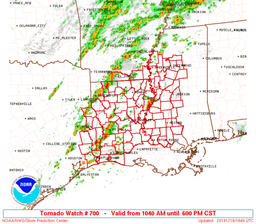
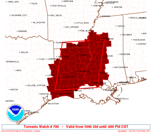
Tornado Watch Number 700
NWS Storm Prediction Center Norman OK
1040 AM CST Mon Dec 16 2019
The NWS Storm Prediction Center has issued a
* Tornado Watch for portions of
Far southern Arkansas
Louisiana
Western and central Mississippi
Far eastern Texas
Coastal Waters
* Effective this Monday morning and evening from 1040 AM until
600 PM CST.
* Primary threats include...
Several tornadoes and a couple intense tornadoes likely
Widespread damaging winds likely with isolated significant gusts
to 75 mph possible
Isolated large hail events to 1.5 inches in diameter possible
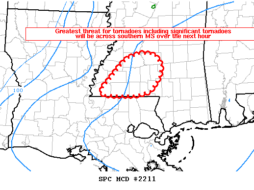
SUMMARY...Several supercells are expected to develop and progress
east-northeast across the Sabine and Lower Mississippi Valleys this
afternoon. Tornadoes and damaging winds are anticipated, with the
peak tornado risk across portions of northern and central Louisiana
into western Mississippi.
The tornado watch area is approximately along and 100 statute miles
east and west of a line from 25 miles west of Lafayette LA to 70
miles north northeast of Monroe LA. For a complete depiction of the
watch see the associated watch outline update (WOUS64 KWNS WOU0).
PRECAUTIONARY/PREPAREDNESS ACTIONS...
REMEMBER...A Tornado Watch means conditions are favorable for
tornadoes and severe thunderstorms in and close to the watch
area. Persons in these areas should be on the lookout for
threatening weather conditions and listen for later statements
and possible warnings.
&&
AVIATION...Tornadoes and a few severe thunderstorms with hail
surface and aloft to 1.5 inches. Extreme turbulence and surface wind
gusts to 65 knots. A few cumulonimbi with maximum tops to 450. Mean
storm motion vector 24040.
...Grams

   SEL0

   URGENT - IMMEDIATE BROADCAST REQUESTED
   Tornado Watch Number 700
   NWS Storm Prediction Center Norman OK
   1040 AM CST Mon Dec 16 2019

   The NWS Storm Prediction Center has issued a

   * Tornado Watch for portions of
     Far southern Arkansas
     Louisiana
     Western and central Mississippi
     Far eastern Texas
     Coastal Waters

   * Effective this Monday morning and evening from 1040 AM until
     600 PM CST.

   * Primary threats include...
     Several tornadoes and a couple intense tornadoes likely
     Widespread damaging winds likely with isolated significant gusts
       to 75 mph possible
     Isolated large hail events to 1.5 inches in diameter possible

   SUMMARY...Several supercells are expected to develop and progress
   east-northeast across the Sabine and Lower Mississippi Valleys this
   afternoon. Tornadoes and damaging winds are anticipated, with the
   peak tornado risk across portions of northern and central Louisiana
   into western Mississippi.

   The tornado watch area is approximately along and 100 statute miles
   east and west of a line from 25 miles west of Lafayette LA to 70
   miles north northeast of Monroe LA. For a complete depiction of the
   watch see the associated watch outline update (WOUS64 KWNS WOU0).

   PRECAUTIONARY/PREPAREDNESS ACTIONS...

   REMEMBER...A Tornado Watch means conditions are favorable for
   tornadoes and severe thunderstorms in and close to the watch
   area. Persons in these areas should be on the lookout for
   threatening weather conditions and listen for later statements
   and possible warnings.

   &&

   AVIATION...Tornadoes and a few severe thunderstorms with hail
   surface and aloft to 1.5 inches. Extreme turbulence and surface wind
   gusts to 65 knots. A few cumulonimbi with maximum tops to 450. Mean
   storm motion vector 24040.

   ...Grams
 Note:
The Aviation Watch (SAW) product is an approximation to the watch area.
The actual watch is depicted by the shaded areas.
Note:
The Aviation Watch (SAW) product is an approximation to the watch area.
The actual watch is depicted by the shaded areas.
   SAW0
   WW 700 TORNADO AR LA MS TX CW 161640Z - 170000Z
   AXIS..100 STATUTE MILES EAST AND WEST OF LINE..
   25W LFT/LAFAYETTE LA/ - 70NNE MLU/MONROE LA/
   ..AVIATION COORDS.. 85NM E/W /37E LCH - 60ENE ELD/
   HAIL SURFACE AND ALOFT..1.5 INCHES. WIND GUSTS..65 KNOTS.
   MAX TOPS TO 450. MEAN STORM MOTION VECTOR 24040.

   LAT...LON 30199406 33439330 33438983 30199072

   THIS IS AN APPROXIMATION TO THE WATCH AREA.  FOR A
   COMPLETE DEPICTION OF THE WATCH SEE WOUS64 KWNS
   FOR WOU0.
Watch 700 Status Report Messages:
STATUS REPORT #6 ON WW 700

VALID 162345Z - 170000Z

SEVERE WEATHER THREAT CONTINUES RIGHT OF A LINE FROM 15 ENE LCH
TO 40 ESE ESF TO 30 NNW MCB TO 75 NW PIB.

WW 700 WILL BE EXTENDED FOR PORTIONS OF THE ONGOING WATCH THROUGH
AT LEAST 02 UTC PER LOCAL NWS OFFICE COORDINATION.

..SMITH..12/16/19

ATTN...WFO...JAN...SHV...LCH...LIX...

&&

STATUS REPORT FOR WT 700

SEVERE WEATHER THREAT CONTINUES FOR THE FOLLOWING AREAS

LAC001-009-019-023-033-037-039-053-063-077-091-097-105-117-121-
125-170000-

LA
.    LOUISIANA PARISHES INCLUDED ARE

ACADIA		     AVOYELLES		 CALCASIEU
CAMERON 	     EAST BATON ROUGE	 EAST FELICIANA
EVANGELINE	     JEFFERSON DAVIS	 LIVINGSTON
POINTE COUPEE	     ST. HELENA 	 ST. LANDRY
TANGIPAHOA	     WASHINGTON 	 WEST BATON ROUGE
WEST FELICIANA
$$


MSC005-007-029-037-049-051-077-085-089-113-121-127-147-157-163-
170000-

MS
.    MISSISSIPPI COUNTIES INCLUDED ARE

AMITE		     ATTALA		 COPIAH
FRANKLIN	     HINDS		 HOLMES
LAWRENCE	     LINCOLN		 MADISON
PIKE		     RANKIN		 SIMPSON
WALTHALL	     WILKINSON		 YAZOO
$$


GMZ432-170000-

CW

.    ADJACENT COASTAL WATERS INCLUDED ARE

CALCASIEU LAKE

$$
THE WATCH STATUS MESSAGE IS FOR GUIDANCE PURPOSES ONLY.  PLEASE
REFER TO WATCH COUNTY NOTIFICATION STATEMENTS FOR OFFICIAL
INFORMATION ON COUNTIES...INDEPENDENT CITIES AND MARINE ZONES
CLEARED FROM SEVERE THUNDERSTORM AND TORNADO WATCHES.
$$

STATUS REPORT #5 ON WW 700

VALID 162255Z - 162340Z

SEVERE WEATHER THREAT CONTINUES RIGHT OF A LINE FROM 10 WNW LCH
TO 10 SW HEZ TO 50 SSE GLH TO 20 SE GWO.

..SMITH..12/16/19

ATTN...WFO...JAN...SHV...LCH...LIX...

&&

STATUS REPORT FOR WT 700

SEVERE WEATHER THREAT CONTINUES FOR THE FOLLOWING AREAS

LAC001-003-009-019-023-029-033-037-039-053-063-077-091-097-105-
117-121-125-162340-

LA
.    LOUISIANA PARISHES INCLUDED ARE

ACADIA		     ALLEN		 AVOYELLES
CALCASIEU	     CAMERON		 CONCORDIA
EAST BATON ROUGE     EAST FELICIANA	 EVANGELINE
JEFFERSON DAVIS      LIVINGSTON 	 POINTE COUPEE
ST. HELENA	     ST. LANDRY 	 TANGIPAHOA
WASHINGTON	     WEST BATON ROUGE	 WEST FELICIANA
$$


MSC001-005-007-021-029-037-049-051-063-077-085-089-113-121-127-
147-149-157-163-162340-

MS
.    MISSISSIPPI COUNTIES INCLUDED ARE

ADAMS		     AMITE		 ATTALA
CLAIBORNE	     COPIAH		 FRANKLIN
HINDS		     HOLMES		 JEFFERSON
LAWRENCE	     LINCOLN		 MADISON
PIKE		     RANKIN		 SIMPSON
WALTHALL	     WARREN		 WILKINSON
YAZOO
$$


GMZ432-162340-

CW

.    ADJACENT COASTAL WATERS INCLUDED ARE

CALCASIEU LAKE

$$
THE WATCH STATUS MESSAGE IS FOR GUIDANCE PURPOSES ONLY.  PLEASE
REFER TO WATCH COUNTY NOTIFICATION STATEMENTS FOR OFFICIAL
INFORMATION ON COUNTIES...INDEPENDENT CITIES AND MARINE ZONES
CLEARED FROM SEVERE THUNDERSTORM AND TORNADO WATCHES.
$$

STATUS REPORT #4 ON WW 700

VALID 162140Z - 162240Z

SEVERE WEATHER THREAT CONTINUES RIGHT OF A LINE FROM 15 NNW BPT
TO 15 N ESF TO 20 ESE MLU TO 25 E GLH.

..MOSIER..12/16/19

ATTN...WFO...JAN...SHV...LCH...LIX...

&&

STATUS REPORT FOR WT 700

SEVERE WEATHER THREAT CONTINUES FOR THE FOLLOWING AREAS

LAC001-003-009-011-019-023-025-029-033-035-037-039-041-053-063-
065-077-079-083-091-097-105-107-117-121-125-162240-

LA
.    LOUISIANA PARISHES INCLUDED ARE

ACADIA		     ALLEN		 AVOYELLES
BEAUREGARD	     CALCASIEU		 CAMERON
CATAHOULA	     CONCORDIA		 EAST BATON ROUGE
EAST CARROLL	     EAST FELICIANA	 EVANGELINE
FRANKLIN	     JEFFERSON DAVIS	 LIVINGSTON
MADISON 	     POINTE COUPEE	 RAPIDES
RICHLAND	     ST. HELENA 	 ST. LANDRY
TANGIPAHOA	     TENSAS		 WASHINGTON
WEST BATON ROUGE     WEST FELICIANA
$$


MSC001-005-007-015-021-029-037-043-049-051-053-055-063-077-083-
085-089-097-113-121-125-127-147-149-157-163-162240-

MS
.    MISSISSIPPI COUNTIES INCLUDED ARE

ADAMS		     AMITE		 ATTALA
CARROLL 	     CLAIBORNE		 COPIAH
FRANKLIN	     GRENADA		 HINDS
HOLMES		     HUMPHREYS		 ISSAQUENA
JEFFERSON	     LAWRENCE		 LEFLORE
LINCOLN 	     MADISON		 MONTGOMERY
PIKE		     RANKIN		 SHARKEY
SIMPSON 	     WALTHALL		 WARREN
WILKINSON	     YAZOO
$$


GMZ432-162240-

CW

.    ADJACENT COASTAL WATERS INCLUDED ARE

CALCASIEU LAKE

$$
THE WATCH STATUS MESSAGE IS FOR GUIDANCE PURPOSES ONLY.  PLEASE
REFER TO WATCH COUNTY NOTIFICATION STATEMENTS FOR OFFICIAL
INFORMATION ON COUNTIES...INDEPENDENT CITIES AND MARINE ZONES
CLEARED FROM SEVERE THUNDERSTORM AND TORNADO WATCHES.
$$

STATUS REPORT #3 ON WW 700

VALID 162045Z - 162140Z

SEVERE WEATHER THREAT CONTINUES RIGHT OF A LINE FROM 45 N BPT TO
5 N GLH.

..MOSIER..12/16/19

ATTN...WFO...JAN...SHV...LCH...LIX...

&&

STATUS REPORT FOR WT 700

SEVERE WEATHER THREAT CONTINUES FOR THE FOLLOWING AREAS

ARC017-162140-

AR
.    ARKANSAS COUNTIES INCLUDED ARE

CHICOT
$$


LAC001-003-009-011-019-021-023-025-029-033-035-037-039-041-043-
053-059-063-065-067-077-079-083-091-097-105-107-115-117-121-123-
125-162140-

LA
.    LOUISIANA PARISHES INCLUDED ARE

ACADIA		     ALLEN		 AVOYELLES
BEAUREGARD	     CALCASIEU		 CALDWELL
CAMERON 	     CATAHOULA		 CONCORDIA
EAST BATON ROUGE     EAST CARROLL	 EAST FELICIANA
EVANGELINE	     FRANKLIN		 GRANT
JEFFERSON DAVIS      LA SALLE		 LIVINGSTON
MADISON 	     MOREHOUSE		 POINTE COUPEE
RAPIDES 	     RICHLAND		 ST. HELENA
ST. LANDRY	     TANGIPAHOA 	 TENSAS
VERNON		     WASHINGTON 	 WEST BATON ROUGE
WEST CARROLL	     WEST FELICIANA
$$


MSC001-005-007-011-015-021-029-037-043-049-051-053-055-063-077-
083-085-089-097-113-121-125-127-133-147-149-151-157-163-
162140-

MS
.    MISSISSIPPI COUNTIES INCLUDED ARE

ADAMS		     AMITE		 ATTALA
BOLIVAR 	     CARROLL		 CLAIBORNE
COPIAH		     FRANKLIN		 GRENADA
HINDS		     HOLMES		 HUMPHREYS
ISSAQUENA	     JEFFERSON		 LAWRENCE
LEFLORE 	     LINCOLN		 MADISON
MONTGOMERY	     PIKE		 RANKIN
SHARKEY 	     SIMPSON		 SUNFLOWER
WALTHALL	     WARREN		 WASHINGTON
WILKINSON	     YAZOO
$$


TXC245-351-361-162140-

TX
.    TEXAS COUNTIES INCLUDED ARE

JEFFERSON	     NEWTON		 ORANGE
$$


GMZ430-432-162140-

CW

.    ADJACENT COASTAL WATERS INCLUDED ARE

SABINE LAKE

CALCASIEU LAKE

$$
THE WATCH STATUS MESSAGE IS FOR GUIDANCE PURPOSES ONLY.  PLEASE
REFER TO WATCH COUNTY NOTIFICATION STATEMENTS FOR OFFICIAL
INFORMATION ON COUNTIES...INDEPENDENT CITIES AND MARINE ZONES
CLEARED FROM SEVERE THUNDERSTORM AND TORNADO WATCHES.
$$

STATUS REPORT #2 ON WW 700

VALID 161930Z - 162040Z

SEVERE WEATHER THREAT CONTINUES RIGHT OF A LINE FROM 45 WNW POE
TO 15 SW LLQ.

FOR ADDITIONAL INFORMATION SEE MESOSCALE DISCUSSION 2208

..MOSIER..12/16/19

ATTN...WFO...JAN...SHV...LCH...LIX...

&&

STATUS REPORT FOR WT 700

SEVERE WEATHER THREAT CONTINUES FOR THE FOLLOWING AREAS

ARC003-017-162040-

AR
.    ARKANSAS COUNTIES INCLUDED ARE

ASHLEY		     CHICOT
$$


LAC001-003-009-011-013-019-021-023-025-029-033-035-037-039-041-
043-049-053-059-061-063-065-067-069-073-077-079-083-085-091-097-
105-107-111-115-117-121-123-125-127-162040-

LA
.    LOUISIANA PARISHES INCLUDED ARE

ACADIA		     ALLEN		 AVOYELLES
BEAUREGARD	     BIENVILLE		 CALCASIEU
CALDWELL	     CAMERON		 CATAHOULA
CONCORDIA	     EAST BATON ROUGE	 EAST CARROLL
EAST FELICIANA	     EVANGELINE 	 FRANKLIN
GRANT		     JACKSON		 JEFFERSON DAVIS
LA SALLE	     LINCOLN		 LIVINGSTON
MADISON 	     MOREHOUSE		 NATCHITOCHES
OUACHITA	     POINTE COUPEE	 RAPIDES
RICHLAND	     SABINE		 ST. HELENA
ST. LANDRY	     TANGIPAHOA 	 TENSAS
UNION		     VERNON		 WASHINGTON
WEST BATON ROUGE     WEST CARROLL	 WEST FELICIANA
WINN
$$


MSC001-005-007-011-015-021-029-037-043-049-051-053-055-063-077-
083-085-089-097-113-121-125-127-133-147-149-151-157-163-
162040-

MS
.    MISSISSIPPI COUNTIES INCLUDED ARE

ADAMS		     AMITE		 ATTALA
BOLIVAR 	     CARROLL		 CLAIBORNE
COPIAH		     FRANKLIN		 GRENADA
HINDS		     HOLMES		 HUMPHREYS
ISSAQUENA	     JEFFERSON		 LAWRENCE
LEFLORE 	     LINCOLN		 MADISON
MONTGOMERY	     PIKE		 RANKIN
SHARKEY 	     SIMPSON		 SUNFLOWER
WALTHALL	     WARREN		 WASHINGTON
WILKINSON	     YAZOO
$$


TXC199-241-245-351-361-403-457-162040-

TX
.    TEXAS COUNTIES INCLUDED ARE

HARDIN		     JASPER		 JEFFERSON
NEWTON		     ORANGE		 SABINE
TYLER
$$


GMZ430-432-162040-

CW

.    ADJACENT COASTAL WATERS INCLUDED ARE

SABINE LAKE

CALCASIEU LAKE

$$
THE WATCH STATUS MESSAGE IS FOR GUIDANCE PURPOSES ONLY.  PLEASE
REFER TO WATCH COUNTY NOTIFICATION STATEMENTS FOR OFFICIAL
INFORMATION ON COUNTIES...INDEPENDENT CITIES AND MARINE ZONES
CLEARED FROM SEVERE THUNDERSTORM AND TORNADO WATCHES.
$$

STATUS REPORT #1 ON WW 700

VALID 161840Z - 161940Z

THE SEVERE WEATHER THREAT CONTINUES ACROSS THE ENTIRE WATCH AREA.

FOR ADDITIONAL INFORMATION SEE MESOSCALE DISCUSSION 2205

..MOSIER..12/16/19

ATTN...WFO...JAN...SHV...LCH...LIX...

&&

STATUS REPORT FOR WT 700

SEVERE WEATHER THREAT CONTINUES FOR THE FOLLOWING AREAS

ARC003-017-139-161940-

AR
.    ARKANSAS COUNTIES INCLUDED ARE

ASHLEY		     CHICOT		 UNION
$$


LAC001-003-009-011-013-019-021-023-025-027-029-031-033-035-037-
039-041-043-049-053-059-061-063-065-067-069-073-077-079-081-083-
085-091-097-105-107-111-115-117-119-121-123-125-127-161940-

LA
.    LOUISIANA PARISHES INCLUDED ARE

ACADIA		     ALLEN		 AVOYELLES
BEAUREGARD	     BIENVILLE		 CALCASIEU
CALDWELL	     CAMERON		 CATAHOULA
CLAIBORNE	     CONCORDIA		 DE SOTO
EAST BATON ROUGE     EAST CARROLL	 EAST FELICIANA
EVANGELINE	     FRANKLIN		 GRANT
JACKSON 	     JEFFERSON DAVIS	 LA SALLE
LINCOLN 	     LIVINGSTON 	 MADISON
MOREHOUSE	     NATCHITOCHES	 OUACHITA
POINTE COUPEE	     RAPIDES		 RED RIVER
RICHLAND	     SABINE		 ST. HELENA
ST. LANDRY	     TANGIPAHOA 	 TENSAS
UNION		     VERNON		 WASHINGTON
WEBSTER 	     WEST BATON ROUGE	 WEST CARROLL
WEST FELICIANA	     WINN
$$


MSC001-005-007-011-015-021-029-037-043-049-051-053-055-063-077-
083-085-089-097-113-121-125-127-133-147-149-151-157-163-
161940-

MS
.    MISSISSIPPI COUNTIES INCLUDED ARE

ADAMS		     AMITE		 ATTALA
BOLIVAR 	     CARROLL		 CLAIBORNE
COPIAH		     FRANKLIN		 GRENADA
HINDS		     HOLMES		 HUMPHREYS
ISSAQUENA	     JEFFERSON		 LAWRENCE
LEFLORE 	     LINCOLN		 MADISON
MONTGOMERY	     PIKE		 RANKIN
SHARKEY 	     SIMPSON		 SUNFLOWER
WALTHALL	     WARREN		 WASHINGTON
WILKINSON	     YAZOO
$$


TXC199-241-245-351-361-403-405-419-457-161940-

TX
.    TEXAS COUNTIES INCLUDED ARE

HARDIN		     JASPER		 JEFFERSON
NEWTON		     ORANGE		 SABINE
SAN AUGUSTINE	     SHELBY		 TYLER
$$


GMZ430-432-161940-

CW

.    ADJACENT COASTAL WATERS INCLUDED ARE

SABINE LAKE

CALCASIEU LAKE

$$
THE WATCH STATUS MESSAGE IS FOR GUIDANCE PURPOSES ONLY.  PLEASE
REFER TO WATCH COUNTY NOTIFICATION STATEMENTS FOR OFFICIAL
INFORMATION ON COUNTIES...INDEPENDENT CITIES AND MARINE ZONES
CLEARED FROM SEVERE THUNDERSTORM AND TORNADO WATCHES.
$$
Note:
Click for Complete Product Text.
Tornadoes
Probability of 2 or more tornadoes
|
High (80%)
|
Probability of 1 or more strong (EF2-EF5) tornadoes
|
Mod (60%)
|
Wind
Probability of 10 or more severe wind events
|
High (80%)
|
Probability of 1 or more wind events > 65 knots
|
Mod (40%)
|
Hail
Probability of 10 or more severe hail events
|
Mod (30%)
|
Probability of 1 or more hailstones > 2 inches
|
Low (20%)
|
Combined Severe Hail/Wind
Probability of 6 or more combined severe hail/wind events
|
High (>95%)
|
For each watch, probabilities for particular events inside the watch
(listed above in each table) are determined by the issuing forecaster.
The "Low" category contains probability values ranging from less than 2%
to 20% (EF2-EF5 tornadoes), less than 5% to 20% (all other probabilities),
"Moderate" from 30% to 60%, and "High" from 70% to greater than 95%.
High values are bolded and lighter in color to provide awareness of
an increased threat for a particular event.


 @NWSSPC