Note:
The expiration time in the watch graphic is amended if the watch is
replaced, cancelled or extended.
Note:
Note:
The expiration time in the watch graphic is amended if the watch is
replaced, cancelled or extended.
Note: Click for
Watch Status Reports.
SEL8
URGENT - IMMEDIATE BROADCAST REQUESTED
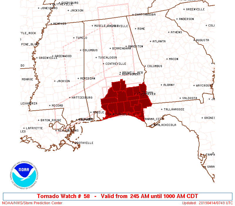
Tornado Watch Number 58
NWS Storm Prediction Center Norman OK
245 AM CDT Sun Apr 14 2019
The NWS Storm Prediction Center has issued a
* Tornado Watch for portions of
Southeastern Alabama
Florida Panhandle
Coastal Waters
* Effective this Sunday morning from 245 AM until 1000 AM CDT.
* Primary threats include...
A couple tornadoes possible
Isolated damaging wind gusts to 70 mph possible
SUMMARY...A band of strong-severe thunderstorms will move across the
watch area through mid/late morning, offering tornado and
damaging-gust threats. See SPC mesoscale discussion 334 for initial
meteorological details.
The tornado watch area is approximately along and 50 statute miles
north and south of a line from 35 miles southwest of Evergreen AL to
20 miles south southeast of Dothan AL. For a complete depiction of
the watch see the associated watch outline update (WOUS64 KWNS
WOU8).
PRECAUTIONARY/PREPAREDNESS ACTIONS...
REMEMBER...A Tornado Watch means conditions are favorable for
tornadoes and severe thunderstorms in and close to the watch
area. Persons in these areas should be on the lookout for
threatening weather conditions and listen for later statements
and possible warnings.
&&
OTHER WATCH INFORMATION...CONTINUE...WW 55...WW 56...WW 57...
AVIATION...Tornadoes and a few severe thunderstorms with hail
surface and aloft to 1 inch. Extreme turbulence and surface wind
gusts to 60 knots. A few cumulonimbi with maximum tops to 500. Mean
storm motion vector 23035.
...Edwards

   SEL8

   URGENT - IMMEDIATE BROADCAST REQUESTED
   Tornado Watch Number 58
   NWS Storm Prediction Center Norman OK
   245 AM CDT Sun Apr 14 2019

   The NWS Storm Prediction Center has issued a

   * Tornado Watch for portions of
     Southeastern Alabama
     Florida Panhandle
     Coastal Waters

   * Effective this Sunday morning from 245 AM until 1000 AM CDT.

   * Primary threats include...
     A couple tornadoes possible
     Isolated damaging wind gusts to 70 mph possible

   SUMMARY...A band of strong-severe thunderstorms will move across the
   watch area through mid/late morning, offering tornado and
   damaging-gust threats.  See SPC mesoscale discussion 334 for initial
   meteorological details.

   The tornado watch area is approximately along and 50 statute miles
   north and south of a line from 35 miles southwest of Evergreen AL to
   20 miles south southeast of Dothan AL. For a complete depiction of
   the watch see the associated watch outline update (WOUS64 KWNS
   WOU8).

   PRECAUTIONARY/PREPAREDNESS ACTIONS...

   REMEMBER...A Tornado Watch means conditions are favorable for
   tornadoes and severe thunderstorms in and close to the watch
   area. Persons in these areas should be on the lookout for
   threatening weather conditions and listen for later statements
   and possible warnings.

   &&

   OTHER WATCH INFORMATION...CONTINUE...WW 55...WW 56...WW 57...

   AVIATION...Tornadoes and a few severe thunderstorms with hail
   surface and aloft to 1 inch. Extreme turbulence and surface wind
   gusts to 60 knots. A few cumulonimbi with maximum tops to 500. Mean
   storm motion vector 23035.

   ...Edwards
 Note:
The Aviation Watch (SAW) product is an approximation to the watch area.
The actual watch is depicted by the shaded areas.
Note:
The Aviation Watch (SAW) product is an approximation to the watch area.
The actual watch is depicted by the shaded areas.
   SAW8
   WW 58 TORNADO AL FL CW 140745Z - 141500Z
   AXIS..50 STATUTE MILES NORTH AND SOUTH OF LINE..
   35SW GZH/EVERGREEN AL/ - 20SSE DHN/DOTHAN AL/
   ..AVIATION COORDS.. 45NM N/S /42WNW CEW - 57WNW TLH/
   HAIL SURFACE AND ALOFT..1 INCH. WIND GUSTS..60 KNOTS.
   MAX TOPS TO 500. MEAN STORM MOTION VECTOR 23035.

   LAT...LON 31788745 31788531 30328531 30348745

   THIS IS AN APPROXIMATION TO THE WATCH AREA.  FOR A
   COMPLETE DEPICTION OF THE WATCH SEE WOUS64 KWNS
   FOR WOU8.
Watch 58 Status Report Messages:
STATUS REPORT #4 ON WW 58

VALID 141340Z - 141440Z

SEVERE WEATHER THREAT CONTINUES RIGHT OF A LINE FROM 30 S CEW TO
10 SW TOI.

..KERR..04/14/19

ATTN...WFO...MOB...TAE...

&&

STATUS REPORT FOR WT 58

SEVERE WEATHER THREAT CONTINUES FOR THE FOLLOWING AREAS

ALC031-045-061-067-069-141440-

AL
.    ALABAMA COUNTIES INCLUDED ARE

COFFEE		     DALE		 GENEVA
HENRY		     HOUSTON
$$


FLC005-013-037-045-059-063-077-131-133-141440-

FL
.    FLORIDA COUNTIES INCLUDED ARE

BAY		     CALHOUN		 FRANKLIN
GULF		     HOLMES		 JACKSON
LIBERTY 	     WALTON		 WASHINGTON
$$


GMZ636-141440-

CW

.    ADJACENT COASTAL WATERS INCLUDED ARE

EASTERN CHOCTAWHATCHEE BAY

$$
THE WATCH STATUS MESSAGE IS FOR GUIDANCE PURPOSES ONLY.  PLEASE
REFER TO WATCH COUNTY NOTIFICATION STATEMENTS FOR OFFICIAL
INFORMATION ON COUNTIES...INDEPENDENT CITIES AND MARINE ZONES
CLEARED FROM SEVERE THUNDERSTORM AND TORNADO WATCHES.
$$

STATUS REPORT #3 ON WW 58

VALID 141250Z - 141340Z

SEVERE WEATHER THREAT CONTINUES RIGHT OF A LINE FROM 30 SSE PNS
TO 20 ENE PNS TO 10 N CEW TO 35 E GZH TO 30 SSW MGM.

..COOK..04/14/19

ATTN...WFO...MOB...TAE...

&&

STATUS REPORT FOR WT 58

SEVERE WEATHER THREAT CONTINUES FOR THE FOLLOWING AREAS

ALC031-039-041-045-061-067-069-141340-

AL
.    ALABAMA COUNTIES INCLUDED ARE

COFFEE		     COVINGTON		 CRENSHAW
DALE		     GENEVA		 HENRY
HOUSTON
$$


FLC005-013-037-045-059-063-077-091-113-131-133-141340-

FL
.    FLORIDA COUNTIES INCLUDED ARE

BAY		     CALHOUN		 FRANKLIN
GULF		     HOLMES		 JACKSON
LIBERTY 	     OKALOOSA		 SANTA ROSA
WALTON		     WASHINGTON
$$


GMZ633-634-635-636-141340-

CW

.    ADJACENT COASTAL WATERS INCLUDED ARE

PERDIDO BAY AREA

PENSACOLA BAY AREA INCLUDING SANTA ROSA SOUND

WESTERN CHOCTAWHATCHEE BAY

EASTERN CHOCTAWHATCHEE BAY

$$
THE WATCH STATUS MESSAGE IS FOR GUIDANCE PURPOSES ONLY.  PLEASE
REFER TO WATCH COUNTY NOTIFICATION STATEMENTS FOR OFFICIAL
INFORMATION ON COUNTIES...INDEPENDENT CITIES AND MARINE ZONES
CLEARED FROM SEVERE THUNDERSTORM AND TORNADO WATCHES.
$$

STATUS REPORT #2 ON WW 58

VALID 141000Z - 141140Z

THE SEVERE WEATHER THREAT CONTINUES ACROSS THE ENTIRE WATCH AREA.

..GOSS..04/14/19

ATTN...WFO...MOB...TAE...

&&

STATUS REPORT FOR WT 58

SEVERE WEATHER THREAT CONTINUES FOR THE FOLLOWING AREAS

ALC013-031-035-039-041-045-053-061-067-069-141140-

AL
.    ALABAMA COUNTIES INCLUDED ARE

BUTLER		     COFFEE		 CONECUH
COVINGTON	     CRENSHAW		 DALE
ESCAMBIA	     GENEVA		 HENRY
HOUSTON
$$


FLC005-033-059-063-091-113-131-133-141140-

FL
.    FLORIDA COUNTIES INCLUDED ARE

BAY		     ESCAMBIA		 HOLMES
JACKSON 	     OKALOOSA		 SANTA ROSA
WALTON		     WASHINGTON
$$


GMZ633-634-635-636-141140-

CW

.    ADJACENT COASTAL WATERS INCLUDED ARE

PERDIDO BAY AREA

PENSACOLA BAY AREA INCLUDING SANTA ROSA SOUND

WESTERN CHOCTAWHATCHEE BAY

EASTERN CHOCTAWHATCHEE BAY

$$
THE WATCH STATUS MESSAGE IS FOR GUIDANCE PURPOSES ONLY.  PLEASE
REFER TO WATCH COUNTY NOTIFICATION STATEMENTS FOR OFFICIAL
INFORMATION ON COUNTIES...INDEPENDENT CITIES AND MARINE ZONES
CLEARED FROM SEVERE THUNDERSTORM AND TORNADO WATCHES.
$$

STATUS REPORT #1 ON WW 58

VALID 140835Z - 140940Z

THE SEVERE WEATHER THREAT CONTINUES ACROSS THE ENTIRE WATCH AREA.

..COOK..04/14/19

ATTN...WFO...MOB...TAE...

&&

STATUS REPORT FOR WT 58

SEVERE WEATHER THREAT CONTINUES FOR THE FOLLOWING AREAS

ALC013-031-035-039-041-045-053-061-067-069-140940-

AL
.    ALABAMA COUNTIES INCLUDED ARE

BUTLER		     COFFEE		 CONECUH
COVINGTON	     CRENSHAW		 DALE
ESCAMBIA	     GENEVA		 HENRY
HOUSTON
$$


FLC005-033-059-063-091-113-131-133-140940-

FL
.    FLORIDA COUNTIES INCLUDED ARE

BAY		     ESCAMBIA		 HOLMES
JACKSON 	     OKALOOSA		 SANTA ROSA
WALTON		     WASHINGTON
$$


GMZ633-634-635-636-140940-

CW

.    ADJACENT COASTAL WATERS INCLUDED ARE

PERDIDO BAY AREA

PENSACOLA BAY AREA INCLUDING SANTA ROSA SOUND

WESTERN CHOCTAWHATCHEE BAY

EASTERN CHOCTAWHATCHEE BAY

$$
THE WATCH STATUS MESSAGE IS FOR GUIDANCE PURPOSES ONLY.  PLEASE
REFER TO WATCH COUNTY NOTIFICATION STATEMENTS FOR OFFICIAL
INFORMATION ON COUNTIES...INDEPENDENT CITIES AND MARINE ZONES
CLEARED FROM SEVERE THUNDERSTORM AND TORNADO WATCHES.
$$
Note:
Click for Complete Product Text.
Tornadoes
Probability of 2 or more tornadoes
|
Mod (30%)
|
Probability of 1 or more strong (EF2-EF5) tornadoes
|
Low (20%)
|
Wind
Probability of 10 or more severe wind events
|
Mod (30%)
|
Probability of 1 or more wind events > 65 knots
|
Low (10%)
|
Hail
Probability of 10 or more severe hail events
|
Low (10%)
|
Probability of 1 or more hailstones > 2 inches
|
Low (<5%)
|
Combined Severe Hail/Wind
Probability of 6 or more combined severe hail/wind events
|
Mod (40%)
|
For each watch, probabilities for particular events inside the watch
(listed above in each table) are determined by the issuing forecaster.
The "Low" category contains probability values ranging from less than 2%
to 20% (EF2-EF5 tornadoes), less than 5% to 20% (all other probabilities),
"Moderate" from 30% to 60%, and "High" from 70% to greater than 95%.
High values are bolded and lighter in color to provide awareness of
an increased threat for a particular event.


 @NWSSPC