Note:
The expiration time in the watch graphic is amended if the watch is
replaced, cancelled or extended.
Note:
Note:
The expiration time in the watch graphic is amended if the watch is
replaced, cancelled or extended.
Note: Click for
Watch Status Reports.
SEL2
URGENT - IMMEDIATE BROADCAST REQUESTED
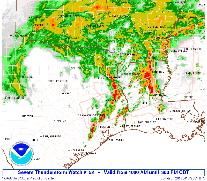
Severe Thunderstorm Watch Number 52
NWS Storm Prediction Center Norman OK
1000 AM CDT Sat Apr 13 2019
The NWS Storm Prediction Center has issued a
* Severe Thunderstorm Watch for portions of
Far southwest Arkansas
Northern Louisiana
Eastern Texas
* Effective this Saturday morning and afternoon from 1000 AM
until 300 PM CDT.
* Primary threats include...
Scattered large hail and isolated very large hail events to 2.5
inches in diameter likely
Scattered damaging wind gusts to 70 mph possible
A tornado or two possible
SUMMARY...Discrete cells and clusters should evolve north-northeast,
generally north of a warm front. Primary hazard through early
afternoon is large hail.
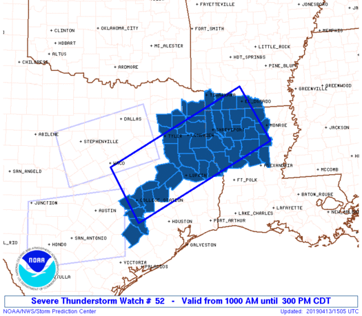
The severe thunderstorm watch area is approximately along and 60
statute miles either side of a line from 25 miles west northwest of
College Station TX to 35 miles southeast of El Dorado AR. For a
complete depiction of the watch see the associated watch outline
update (WOUS64 KWNS WOU2).
PRECAUTIONARY/PREPAREDNESS ACTIONS...
REMEMBER...A Severe Thunderstorm Watch means conditions are
favorable for severe thunderstorms in and close to the watch area.
Persons in these areas should be on the lookout for threatening
weather conditions and listen for later statements and possible
warnings. Severe thunderstorms can and occasionally do produce
tornadoes.
&&
OTHER WATCH INFORMATION...CONTINUE...WW 50...WW 51...
AVIATION...A few severe thunderstorms with hail surface and aloft to
2.5 inches. Extreme turbulence and surface wind gusts to 60 knots. A
few cumulonimbi with maximum tops to 550. Mean storm motion vector
20040.
...Grams

   SEL2

   URGENT - IMMEDIATE BROADCAST REQUESTED
   Severe Thunderstorm Watch Number 52
   NWS Storm Prediction Center Norman OK
   1000 AM CDT Sat Apr 13 2019

   The NWS Storm Prediction Center has issued a

   * Severe Thunderstorm Watch for portions of
     Far southwest Arkansas
     Northern Louisiana
     Eastern Texas

   * Effective this Saturday morning and afternoon from 1000 AM
     until 300 PM CDT.

   * Primary threats include...
     Scattered large hail and isolated very large hail events to 2.5
       inches in diameter likely
     Scattered damaging wind gusts to 70 mph possible
     A tornado or two possible

   SUMMARY...Discrete cells and clusters should evolve north-northeast,
   generally north of a warm front. Primary hazard through early
   afternoon is large hail.

   The severe thunderstorm watch area is approximately along and 60
   statute miles either side of a line from 25 miles west northwest of
   College Station TX to 35 miles southeast of El Dorado AR. For a
   complete depiction of the watch see the associated watch outline
   update (WOUS64 KWNS WOU2).

   PRECAUTIONARY/PREPAREDNESS ACTIONS...

   REMEMBER...A Severe Thunderstorm Watch means conditions are
   favorable for severe thunderstorms in and close to the watch area.
   Persons in these areas should be on the lookout for threatening
   weather conditions and listen for later statements and possible
   warnings. Severe thunderstorms can and occasionally do produce
   tornadoes.

   &&

   OTHER WATCH INFORMATION...CONTINUE...WW 50...WW 51...

   AVIATION...A few severe thunderstorms with hail surface and aloft to
   2.5 inches. Extreme turbulence and surface wind gusts to 60 knots. A
   few cumulonimbi with maximum tops to 550. Mean storm motion vector
   20040.

   ...Grams
 Note:
The Aviation Watch (SAW) product is an approximation to the watch area.
The actual watch is depicted by the shaded areas.
Note:
The Aviation Watch (SAW) product is an approximation to the watch area.
The actual watch is depicted by the shaded areas.
   SAW2
   WW 52 SEVERE TSTM AR LA TX 131500Z - 132000Z
   AXIS..60 STATUTE MILES EITHER SIDE OF LINE..
   25WNW CLL/COLLEGE STATION TX/ - 35SE ELD/EL DORADO AR/
   ..AVIATION COORDS.. 50NM EITHER SIDE /45ENE CWK - 28NW MLU/
   HAIL SURFACE AND ALOFT..2.5 INCHES. WIND GUSTS..60 KNOTS.
   MAX TOPS TO 550. MEAN STORM MOTION VECTOR 20040.

   LAT...LON 31509719 33639283 32089194 29939633

   THIS IS AN APPROXIMATION TO THE WATCH AREA.  FOR A
   COMPLETE DEPICTION OF THE WATCH SEE WOUS64 KWNS
   FOR WOU2.
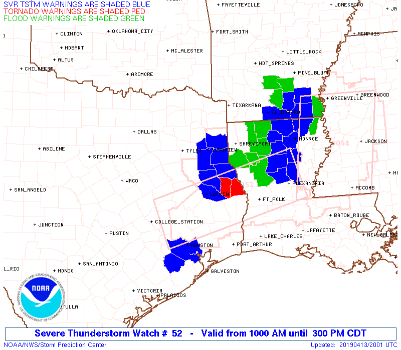
Watch 52 Status Report Messages:
STATUS REPORT #5 ON WW 52

VALID 131925Z - 132000Z

SEVERE WEATHER THREAT CONTINUES RIGHT OF A LINE FROM 15 WNW MLU
TO 20 S GGG TO 10 NE TYR.

PARTS OF REMAINING VALID PORTION OF WW ACROSS NORTHEAST TEXAS INTO
NORTHERN LOUISIANA WILL BE ADDED TO TORNADO WATCH 53 PRIOR TO 20Z
EXPIRATION.

..KERR..04/13/19

ATTN...WFO...SHV...HGX...

&&

STATUS REPORT FOR WS 52

SEVERE WEATHER THREAT CONTINUES FOR THE FOLLOWING AREAS

ARC027-073-091-139-132000-

AR
.    ARKANSAS COUNTIES INCLUDED ARE

COLUMBIA	     LAFAYETTE		 MILLER
UNION
$$


LAC015-017-027-061-111-119-132000-

LA
.    LOUISIANA PARISHES INCLUDED ARE

BOSSIER 	     CADDO		 CLAIBORNE
LINCOLN 	     UNION		 WEBSTER
$$


TXC063-067-183-203-315-343-423-459-499-132000-

TX
.    TEXAS COUNTIES INCLUDED ARE

CAMP		     CASS		 GREGG
HARRISON	     MARION		 MORRIS
SMITH		     UPSHUR		 WOOD
$$


THE WATCH STATUS MESSAGE IS FOR GUIDANCE PURPOSES ONLY.  PLEASE
REFER TO WATCH COUNTY NOTIFICATION STATEMENTS FOR OFFICIAL
INFORMATION ON COUNTIES...INDEPENDENT CITIES AND MARINE ZONES
CLEARED FROM SEVERE THUNDERSTORM AND TORNADO WATCHES.
$$

STATUS REPORT #4 ON WW 52

VALID 131845Z - 131940Z

SEVERE WEATHER THREAT CONTINUES RIGHT OF A LINE FROM 45 SSE CLL
TO 55 N UTS TO 25 W TYR.

..WENDT..04/13/19

ATTN...WFO...SHV...HGX...

&&

STATUS REPORT FOR WS 52

SEVERE WEATHER THREAT CONTINUES FOR THE FOLLOWING AREAS

ARC027-073-091-139-131940-

AR
.    ARKANSAS COUNTIES INCLUDED ARE

COLUMBIA	     LAFAYETTE		 MILLER
UNION
$$


LAC015-017-027-061-111-119-131940-

LA
.    LOUISIANA PARISHES INCLUDED ARE

BOSSIER 	     CADDO		 CLAIBORNE
LINCOLN 	     UNION		 WEBSTER
$$


TXC063-067-183-203-315-343-423-459-499-131940-

TX
.    TEXAS COUNTIES INCLUDED ARE

CAMP		     CASS		 GREGG
HARRISON	     MARION		 MORRIS
SMITH		     UPSHUR		 WOOD
$$


THE WATCH STATUS MESSAGE IS FOR GUIDANCE PURPOSES ONLY.  PLEASE
REFER TO WATCH COUNTY NOTIFICATION STATEMENTS FOR OFFICIAL
INFORMATION ON COUNTIES...INDEPENDENT CITIES AND MARINE ZONES
CLEARED FROM SEVERE THUNDERSTORM AND TORNADO WATCHES.
$$

STATUS REPORT #3 ON WW 52

VALID 131750Z - 131840Z

THE SEVERE WEATHER THREAT CONTINUES ACROSS THE ENTIRE WATCH AREA.
THE COUNTIES THAT HAVE BEEN CLEARED HAVE BEEN REPLACED BY WW 53.

..WENDT..04/13/19

ATTN...WFO...SHV...HGX...

&&

STATUS REPORT FOR WS 52

SEVERE WEATHER THREAT CONTINUES FOR THE FOLLOWING AREAS

ARC027-073-091-139-131840-

AR
.    ARKANSAS COUNTIES INCLUDED ARE

COLUMBIA	     LAFAYETTE		 MILLER
UNION
$$


LAC015-017-027-061-111-119-131840-

LA
.    LOUISIANA PARISHES INCLUDED ARE

BOSSIER 	     CADDO		 CLAIBORNE
LINCOLN 	     UNION		 WEBSTER
$$


TXC015-051-063-067-089-183-203-315-343-423-459-477-499-131840-

TX
.    TEXAS COUNTIES INCLUDED ARE

AUSTIN		     BURLESON		 CAMP
CASS		     COLORADO		 GREGG
HARRISON	     MARION		 MORRIS
SMITH		     UPSHUR		 WASHINGTON
WOOD
$$


THE WATCH STATUS MESSAGE IS FOR GUIDANCE PURPOSES ONLY.  PLEASE
REFER TO WATCH COUNTY NOTIFICATION STATEMENTS FOR OFFICIAL
INFORMATION ON COUNTIES...INDEPENDENT CITIES AND MARINE ZONES
CLEARED FROM SEVERE THUNDERSTORM AND TORNADO WATCHES.
$$

STATUS REPORT #2 ON WW 52

VALID 131750Z - 131840Z

THE SEVERE WEATHER THREAT CONTINUES ACROSS THE ENTIRE WATCH AREA.

..WENDT..04/13/19

ATTN...WFO...SHV...HGX...

&&

STATUS REPORT FOR WS 52

SEVERE WEATHER THREAT CONTINUES FOR THE FOLLOWING AREAS

ARC027-073-091-139-131840-

AR
.    ARKANSAS COUNTIES INCLUDED ARE

COLUMBIA	     LAFAYETTE		 MILLER
UNION
$$


LAC015-017-027-061-111-119-131840-

LA
.    LOUISIANA PARISHES INCLUDED ARE

BOSSIER 	     CADDO		 CLAIBORNE
LINCOLN 	     UNION		 WEBSTER
$$


TXC015-051-063-067-089-183-203-315-343-423-459-477-499-131840-

TX
.    TEXAS COUNTIES INCLUDED ARE

AUSTIN		     BURLESON		 CAMP
CASS		     COLORADO		 GREGG
HARRISON	     MARION		 MORRIS
SMITH		     UPSHUR		 WASHINGTON
WOOD
$$


THE WATCH STATUS MESSAGE IS FOR GUIDANCE PURPOSES ONLY.  PLEASE
REFER TO WATCH COUNTY NOTIFICATION STATEMENTS FOR OFFICIAL
INFORMATION ON COUNTIES...INDEPENDENT CITIES AND MARINE ZONES
CLEARED FROM SEVERE THUNDERSTORM AND TORNADO WATCHES.
$$

STATUS REPORT #1 ON WW 52

VALID 131745Z - 131840Z

THE SEVERE WEATHER THREAT CONTINUES ACROSS THE ENTIRE WATCH AREA.

..WENDT..04/13/19

ATTN...WFO...SHV...HGX...

&&

STATUS REPORT FOR WS 52

SEVERE WEATHER THREAT CONTINUES FOR THE FOLLOWING AREAS

ARC027-073-091-139-131840-

AR
.    ARKANSAS COUNTIES INCLUDED ARE

COLUMBIA	     LAFAYETTE		 MILLER
UNION
$$


LAC015-017-027-061-069-111-119-131840-

LA
.    LOUISIANA PARISHES INCLUDED ARE

BOSSIER 	     CADDO		 CLAIBORNE
LINCOLN 	     NATCHITOCHES	 UNION
WEBSTER
$$


TXC015-051-063-067-089-183-203-315-343-423-459-477-499-131840-

TX
.    TEXAS COUNTIES INCLUDED ARE

AUSTIN		     BURLESON		 CAMP
CASS		     COLORADO		 GREGG
HARRISON	     MARION		 MORRIS
SMITH		     UPSHUR		 WASHINGTON
WOOD
$$


THE WATCH STATUS MESSAGE IS FOR GUIDANCE PURPOSES ONLY.  PLEASE
REFER TO WATCH COUNTY NOTIFICATION STATEMENTS FOR OFFICIAL
INFORMATION ON COUNTIES...INDEPENDENT CITIES AND MARINE ZONES
CLEARED FROM SEVERE THUNDERSTORM AND TORNADO WATCHES.
$$
Note:
Click for Complete Product Text.
Tornadoes
Probability of 2 or more tornadoes
|
Low (20%)
|
Probability of 1 or more strong (EF2-EF5) tornadoes
|
Low (10%)
|
Wind
Probability of 10 or more severe wind events
|
Mod (40%)
|
Probability of 1 or more wind events > 65 knots
|
Low (20%)
|
Hail
Probability of 10 or more severe hail events
|
Mod (60%)
|
Probability of 1 or more hailstones > 2 inches
|
Mod (60%)
|
Combined Severe Hail/Wind
Probability of 6 or more combined severe hail/wind events
|
High (90%)
|
For each watch, probabilities for particular events inside the watch
(listed above in each table) are determined by the issuing forecaster.
The "Low" category contains probability values ranging from less than 2%
to 20% (EF2-EF5 tornadoes), less than 5% to 20% (all other probabilities),
"Moderate" from 30% to 60%, and "High" from 70% to greater than 95%.
High values are bolded and lighter in color to provide awareness of
an increased threat for a particular event.


 @NWSSPC