Note:
The expiration time in the watch graphic is amended if the watch is
replaced, cancelled or extended.
Note:
Note:
The expiration time in the watch graphic is amended if the watch is
replaced, cancelled or extended.
Note: Click for
Watch Status Reports.
SEL4
URGENT - IMMEDIATE BROADCAST REQUESTED
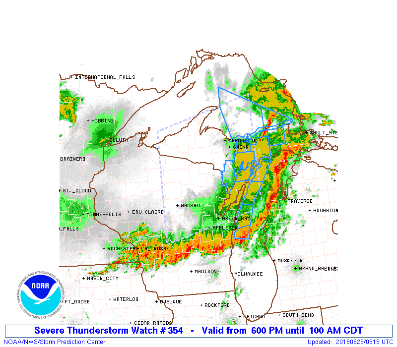
Severe Thunderstorm Watch Number 354
NWS Storm Prediction Center Norman OK
600 PM CDT Mon Aug 27 2018
The NWS Storm Prediction Center has issued a
* Severe Thunderstorm Watch for portions of
Much of Upper Michigan
Northeastern Wisconsin
Lake Michigan
Lake Superior
* Effective this Monday night and Tuesday morning from 600 PM
until 100 AM CDT.
* Primary threats include...
Scattered damaging winds likely with isolated significant gusts
to 75 mph possible
Scattered large hail events to 1.5 inches in diameter possible
A tornado or two possible
SUMMARY...A convective cluster will likely continue eastward along
the shore of Lake Superior through the late evening hours, with an
attendant threat for damaging winds. Farther southwest, a larger
thunderstorm line/cluster now crossing the Mississippi River will
continue across Wisconsin and Upper Michigan into the overnight
hours. Damaging winds will be the main threat, though an isolated
tornado or two cannot be ruled out with circulations embedded within
the larger clusters/lines.
The severe thunderstorm watch area is approximately along and 105
statute miles north and south of a line from 35 miles west southwest
of Rhinelander WI to 45 miles northeast of Escanaba MI. For a
complete depiction of the watch see the associated watch outline
update (WOUS64 KWNS WOU4).
PRECAUTIONARY/PREPAREDNESS ACTIONS...
REMEMBER...A Severe Thunderstorm Watch means conditions are
favorable for severe thunderstorms in and close to the watch area.
Persons in these areas should be on the lookout for threatening
weather conditions and listen for later statements and possible
warnings. Severe thunderstorms can and occasionally do produce
tornadoes.
&&
OTHER WATCH INFORMATION...CONTINUE...WW 353...
AVIATION...A few severe thunderstorms with hail surface and aloft to
1.5 inches. Extreme turbulence and surface wind gusts to 65 knots. A
few cumulonimbi with maximum tops to 550. Mean storm motion vector
24040.
...Thompson

   SEL4

   URGENT - IMMEDIATE BROADCAST REQUESTED
   Severe Thunderstorm Watch Number 354
   NWS Storm Prediction Center Norman OK
   600 PM CDT Mon Aug 27 2018

   The NWS Storm Prediction Center has issued a

   * Severe Thunderstorm Watch for portions of
     Much of Upper Michigan
     Northeastern Wisconsin
     Lake Michigan
     Lake Superior

   * Effective this Monday night and Tuesday morning from 600 PM
     until 100 AM CDT.

   * Primary threats include...
     Scattered damaging winds likely with isolated significant gusts
       to 75 mph possible
     Scattered large hail events to 1.5 inches in diameter possible
     A tornado or two possible

   SUMMARY...A convective cluster will likely continue eastward along
   the shore of Lake Superior through the late evening hours, with an
   attendant threat for damaging winds.  Farther southwest, a larger
   thunderstorm line/cluster now crossing the Mississippi River will
   continue across Wisconsin and Upper Michigan into the overnight
   hours.  Damaging winds will be the main threat, though an isolated
   tornado or two cannot be ruled out with circulations embedded within
   the larger clusters/lines.

   The severe thunderstorm watch area is approximately along and 105
   statute miles north and south of a line from 35 miles west southwest
   of Rhinelander WI to 45 miles northeast of Escanaba MI. For a
   complete depiction of the watch see the associated watch outline
   update (WOUS64 KWNS WOU4).

   PRECAUTIONARY/PREPAREDNESS ACTIONS...

   REMEMBER...A Severe Thunderstorm Watch means conditions are
   favorable for severe thunderstorms in and close to the watch area.
   Persons in these areas should be on the lookout for threatening
   weather conditions and listen for later statements and possible
   warnings. Severe thunderstorms can and occasionally do produce
   tornadoes.

   &&

   OTHER WATCH INFORMATION...CONTINUE...WW 353...

   AVIATION...A few severe thunderstorms with hail surface and aloft to
   1.5 inches. Extreme turbulence and surface wind gusts to 65 knots. A
   few cumulonimbi with maximum tops to 550. Mean storm motion vector
   24040.

   ...Thompson
 Note:
The Aviation Watch (SAW) product is an approximation to the watch area.
The actual watch is depicted by the shaded areas.
Note:
The Aviation Watch (SAW) product is an approximation to the watch area.
The actual watch is depicted by the shaded areas.
   SAW4
   WW 354 SEVERE TSTM MI WI LM LS 272300Z - 280600Z
   AXIS..105 STATUTE MILES NORTH AND SOUTH OF LINE..
   35WSW RHI/RHINELANDER WI/ - 45NE ESC/ESCANABA MI/
   ..AVIATION COORDS.. 90NM N/S /31WSW RHI - 41ESE SAW/
   HAIL SURFACE AND ALOFT..1.5 INCHES. WIND GUSTS..65 KNOTS.
   MAX TOPS TO 550. MEAN STORM MOTION VECTOR 24040.

   LAT...LON 46959013 47708643 44658643 43909013

   THIS IS AN APPROXIMATION TO THE WATCH AREA.  FOR A
   COMPLETE DEPICTION OF THE WATCH SEE WOUS64 KWNS
   FOR WOU4.
Watch 354 Status Report Messages:
STATUS REPORT #2 ON WW 354

VALID 280345Z - 280440Z

SEVERE WEATHER THREAT CONTINUES RIGHT OF A LINE FROM 30 E VOK TO
25 WNW OSH TO 20 NNE OSH TO 10 NNE GRB TO 45 SSE IMT TO 10 SSW
ESC TO 15 ESE ESC TO 30 NE ESC TO 40 E MQT TO 40 NE MQT TO 70 ENE
CMX.

FOR ADDITIONAL INFORMATION SEE MESOSCALE DISCUSSION 1376

..JEWELL..08/28/18

ATTN...WFO...MQT...GRB...

&&

STATUS REPORT FOR WS 354

SEVERE WEATHER THREAT CONTINUES FOR THE FOLLOWING AREAS

MIC003-095-153-280440-

MI
.    MICHIGAN COUNTIES INCLUDED ARE

ALGER		     LUCE		 SCHOOLCRAFT
$$


WIC009-015-029-061-071-139-280440-

WI
.    WISCONSIN COUNTIES INCLUDED ARE

BROWN		     CALUMET		 DOOR
KEWAUNEE	     MANITOWOC		 WINNEBAGO
$$


LMZ221-248-250-261-521-522-541-542-543-563-565-567-LSZ250-251-266-
267-280440-

CW

.    ADJACENT COASTAL WATERS INCLUDED ARE

GREEN BAY NORTH OF LINE FROM CEDAR RIVER MI TO ROCK ISLAND
PASSAGE

SEUL CHOIX POINT TO POINT DETOUR MI

5NM EAST OF A LINE FROM FAIRPORT MI TO ROCK ISLAND PASSAGE

LAKE MICHIGAN FROM SEUL CHOIX POINT TO ROCK ISLAND PASSAGE 5NM
OFFSHORE TO MID LAKE

GREEN BAY SOUTH OF LINE FROM  CEDAR RIVER TO ROCK ISLAND PASSAGE
AND NORTH OF A LINE FROM OCONTO WI TO LITTLE STURGEON BAY WI

GREEN BAY SOUTH OF LINE FROM  OCONTO WI TO LITTLE STURGEON BAY WI

ROCK ISLAND PASSAGE TO STURGEON BAY WI

STURGEON BAY TO TWO RIVERS WI

TWO RIVERS TO SHEBOYGAN WI

LAKE MICHIGAN FROM ROCK ISLAND PASSAGE TO STURGEON BAY WI 5NM
OFFSHORE TO MID LAKE

LAKE MICHIGAN FROM STURGEON BAY TO TWO RIVERS WI 5NM OFFSHORE TO
MID LAKE

LAKE MICHIGAN FROM TWO RIVERS TO SHEBOYGAN WI 5NM OFFSHORE TO MID
LAKE

MUNISING TO GRAND MARAIS MI

GRAND MARAIS TO WHITEFISH POINT MI

LAKE SUPERIOR EAST OF A LINE FROM MANITOU ISLAND TO MARQUETTE MI
AND WEST OF A LINE FROM GRAND MARAIS MI TO THE US/CANADIAN BORDER
BEYOND 5NM FROM SHORE

LAKE SUPERIOR FROM GRAND MARAIS MI TO WHITEFISH POINT MI 5NM OFF
SHORE TO THE US/CANADIAN BORDER

$$
THE WATCH STATUS MESSAGE IS FOR GUIDANCE PURPOSES ONLY.  PLEASE
REFER TO WATCH COUNTY NOTIFICATION STATEMENTS FOR OFFICIAL
INFORMATION ON COUNTIES...INDEPENDENT CITIES AND MARINE ZONES
CLEARED FROM SEVERE THUNDERSTORM AND TORNADO WATCHES.
$$

STATUS REPORT #1 ON WW 354

VALID 280225Z - 280340Z

SEVERE WEATHER THREAT CONTINUES RIGHT OF A LINE FROM 35 WSW CWA
TO 5 SE CWA TO 40 ESE AUW TO 25 NNW GRB TO 35 NNE GRB TO 40 SSE
IMT TO 15 SE IMT TO 15 WNW IMT TO 50 E IWD TO 20 NW CMX.

..JEWELL..08/28/18

ATTN...WFO...MQT...GRB...

&&

STATUS REPORT FOR WS 354

SEVERE WEATHER THREAT CONTINUES FOR THE FOLLOWING AREAS

MIC003-013-041-043-061-071-095-103-109-153-280340-

MI
.    MICHIGAN COUNTIES INCLUDED ARE

ALGER		     BARAGA		 DELTA
DICKINSON	     HOUGHTON		 IRON
LUCE		     MARQUETTE		 MENOMINEE
SCHOOLCRAFT
$$


WIC009-015-029-037-061-071-087-097-115-135-137-139-141-280340-

WI
.    WISCONSIN COUNTIES INCLUDED ARE

BROWN		     CALUMET		 DOOR
FLORENCE	     KEWAUNEE		 MANITOWOC
OUTAGAMIE	     PORTAGE		 SHAWANO
WAUPACA 	     WAUSHARA		 WINNEBAGO
WOOD
$$


LMZ221-248-250-261-521-522-541-542-543-563-565-567-LSZ244-245-246-
247-248-249-250-251-265-266-267-280340-

CW

.    ADJACENT COASTAL WATERS INCLUDED ARE

GREEN BAY NORTH OF LINE FROM CEDAR RIVER MI TO ROCK ISLAND
PASSAGE

SEUL CHOIX POINT TO POINT DETOUR MI

5NM EAST OF A LINE FROM FAIRPORT MI TO ROCK ISLAND PASSAGE

LAKE MICHIGAN FROM SEUL CHOIX POINT TO ROCK ISLAND PASSAGE 5NM
OFFSHORE TO MID LAKE

GREEN BAY SOUTH OF LINE FROM  CEDAR RIVER TO ROCK ISLAND PASSAGE
AND NORTH OF A LINE FROM OCONTO WI TO LITTLE STURGEON BAY WI

GREEN BAY SOUTH OF LINE FROM  OCONTO WI TO LITTLE STURGEON BAY WI

ROCK ISLAND PASSAGE TO STURGEON BAY WI

STURGEON BAY TO TWO RIVERS WI

TWO RIVERS TO SHEBOYGAN WI

LAKE MICHIGAN FROM ROCK ISLAND PASSAGE TO STURGEON BAY WI 5NM
OFFSHORE TO MID LAKE

LAKE MICHIGAN FROM STURGEON BAY TO TWO RIVERS WI 5NM OFFSHORE TO
MID LAKE

LAKE MICHIGAN FROM TWO RIVERS TO SHEBOYGAN WI 5NM OFFSHORE TO MID
LAKE

EAGLE RIVER TO MANITOU ISLAND MI

MANITOU ISLAND TO POINT ISABELLE MI

POINT ISABELLE TO LOWER ENTRANCE OF PORTAGE CANAL MI

PORTAGE LAKE TO HURON ISLAND MI TO LOWER ENTRANCE OF PORTAGE
CANAL TO HURON ISLANDS MI INCLUDING KEWEENAW AND HURON BAYS

HURON ISLANDS TO MARQUETTE MI

MARQUETTE TO MUNISING MI

MUNISING TO GRAND MARAIS MI

GRAND MARAIS TO WHITEFISH POINT MI

LAKE SUPERIOR WEST OF LINE FROM MANITOU ISLAND TO MARQUETTE MI
BEYOND 5NM FROM SHORE

LAKE SUPERIOR EAST OF A LINE FROM MANITOU ISLAND TO MARQUETTE MI
AND WEST OF A LINE FROM GRAND MARAIS MI TO THE US/CANADIAN BORDER
BEYOND 5NM FROM SHORE

LAKE SUPERIOR FROM GRAND MARAIS MI TO WHITEFISH POINT MI 5NM OFF
SHORE TO THE US/CANADIAN BORDER

$$
THE WATCH STATUS MESSAGE IS FOR GUIDANCE PURPOSES ONLY.  PLEASE
REFER TO WATCH COUNTY NOTIFICATION STATEMENTS FOR OFFICIAL
INFORMATION ON COUNTIES...INDEPENDENT CITIES AND MARINE ZONES
CLEARED FROM SEVERE THUNDERSTORM AND TORNADO WATCHES.
$$
Note:
Click for Complete Product Text.
Tornadoes
Probability of 2 or more tornadoes
|
Low (20%)
|
Probability of 1 or more strong (EF2-EF5) tornadoes
|
Low (5%)
|
Wind
Probability of 10 or more severe wind events
|
High (70%)
|
Probability of 1 or more wind events > 65 knots
|
Mod (40%)
|
Hail
Probability of 10 or more severe hail events
|
Mod (40%)
|
Probability of 1 or more hailstones > 2 inches
|
Low (10%)
|
Combined Severe Hail/Wind
Probability of 6 or more combined severe hail/wind events
|
High (90%)
|
For each watch, probabilities for particular events inside the watch
(listed above in each table) are determined by the issuing forecaster.
The "Low" category contains probability values ranging from less than 2%
to 20% (EF2-EF5 tornadoes), less than 5% to 20% (all other probabilities),
"Moderate" from 30% to 60%, and "High" from 70% to greater than 95%.
High values are bolded and lighter in color to provide awareness of
an increased threat for a particular event.


 @NWSSPC