Note:
The expiration time in the watch graphic is amended if the watch is
replaced, cancelled or extended.
Note:
Note:
The expiration time in the watch graphic is amended if the watch is
replaced, cancelled or extended.
Note: Click for
Watch Status Reports.
SEL6
URGENT - IMMEDIATE BROADCAST REQUESTED
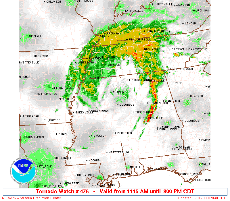
Tornado Watch Number 476
NWS Storm Prediction Center Norman OK
1115 AM CDT Thu Aug 31 2017
The NWS Storm Prediction Center has issued a
* Tornado Watch for portions of
Northern and western Alabama
Northeast Mississippi
Southwest Tennessee
* Effective this Thursday morning and evening from 1115 AM until
800 PM CDT.
* Primary threats include...
A couple tornadoes possible
Isolated damaging wind gusts to 65 mph possible
SUMMARY...Arcing bands of showers and storms will pose a risk for
brief tornadoes this afternoon into early evening.
The tornado watch area is approximately along and 70 statute miles
either side of a line from 60 miles north of Oxford MS to 55 miles
southeast of Tuscaloosa AL. For a complete depiction of the watch
see the associated watch outline update (WOUS64 KWNS WOU6).
PRECAUTIONARY/PREPAREDNESS ACTIONS...
REMEMBER...A Tornado Watch means conditions are favorable for
tornadoes and severe thunderstorms in and close to the watch
area. Persons in these areas should be on the lookout for
threatening weather conditions and listen for later statements
and possible warnings.
&&
AVIATION...Tornadoes and a few severe thunderstorms with hail
surface and aloft to 0.5 inches. Extreme turbulence and surface wind
gusts to 55 knots. A few cumulonimbi with maximum tops to 450. Mean
storm motion vector 20030.
...Grams
 Note:
The Aviation Watch (SAW) product is an approximation to the watch area.
The actual watch is depicted by the shaded areas.
Note:
The Aviation Watch (SAW) product is an approximation to the watch area.
The actual watch is depicted by the shaded areas.
   SAW6
   WW 476 TORNADO AL MS TN 311615Z - 010100Z
   AXIS..70 STATUTE MILES EITHER SIDE OF LINE..
   60N UOX/OXFORD MS/ - 55SE TCL/TUSCALOOSA AL/
   ..AVIATION COORDS.. 60NM EITHER SIDE /25ENE MEM - 41NW MGM/
   HAIL SURFACE AND ALOFT..0.5 INCH. WIND GUSTS..55 KNOTS.
   MAX TOPS TO 450. MEAN STORM MOTION VECTOR 20030.

   LAT...LON 35938861 33348605 31958783 34569043

   THIS IS AN APPROXIMATION TO THE WATCH AREA.  FOR A
   COMPLETE DEPICTION OF THE WATCH SEE WOUS64 KWNS
   FOR WOU6.
Watch 476 Status Report Messages:
STATUS REPORT #5 ON WW 476

VALID 312145Z - 312240Z

SEVERE WEATHER THREAT CONTINUES RIGHT OF A LINE FROM 35 N MEI TO
10 W CBM TO 30 NNE UOX TO MEM.

..GLEASON..08/31/17

ATTN...WFO...BMX...HUN...MEG...JAN...

&&

STATUS REPORT FOR WT 476

SEVERE WEATHER THREAT CONTINUES FOR THE FOLLOWING AREAS

ALC007-009-021-033-043-047-057-059-063-065-073-075-077-079-083-
091-093-103-105-107-117-119-125-127-133-312240-

AL
.    ALABAMA COUNTIES INCLUDED ARE

BIBB		     BLOUNT		 CHILTON
COLBERT 	     CULLMAN		 DALLAS
FAYETTE 	     FRANKLIN		 GREENE
HALE		     JEFFERSON		 LAMAR
LAUDERDALE	     LAWRENCE		 LIMESTONE
MARENGO 	     MARION		 MORGAN
PERRY		     PICKENS		 SHELBY
SUMTER		     TUSCALOOSA 	 WALKER
WINSTON
$$


MSC003-009-025-057-081-087-093-095-103-115-117-139-141-145-
312240-

MS
.    MISSISSIPPI COUNTIES INCLUDED ARE

ALCORN		     BENTON		 CLAY
ITAWAMBA	     LEE		 LOWNDES
MARSHALL	     MONROE		 NOXUBEE
PONTOTOC	     PRENTISS		 TIPPAH
TISHOMINGO	     UNION
$$


TNC023-039-047-069-071-077-109-113-312240-

TN
.    TENNESSEE COUNTIES INCLUDED ARE

CHESTER 	     DECATUR		 FAYETTE
HARDEMAN	     HARDIN		 HENDERSON
MCNAIRY 	     MADISON
$$


THE WATCH STATUS MESSAGE IS FOR GUIDANCE PURPOSES ONLY.  PLEASE
REFER TO WATCH COUNTY NOTIFICATION STATEMENTS FOR OFFICIAL
INFORMATION ON COUNTIES...INDEPENDENT CITIES AND MARINE ZONES
CLEARED FROM SEVERE THUNDERSTORM AND TORNADO WATCHES.
$$

STATUS REPORT #4 ON WW 476

VALID 312025Z - 312140Z

THE SEVERE WEATHER THREAT CONTINUES ACROSS THE ENTIRE WATCH AREA.

..KERR..08/31/17

ATTN...WFO...BMX...HUN...MEG...JAN...

&&

STATUS REPORT FOR WT 476

SEVERE WEATHER THREAT CONTINUES FOR THE FOLLOWING AREAS

ALC007-009-021-033-043-047-057-059-063-065-073-075-077-079-083-
091-093-103-105-107-117-119-125-127-133-312140-

AL
.    ALABAMA COUNTIES INCLUDED ARE

BIBB		     BLOUNT		 CHILTON
COLBERT 	     CULLMAN		 DALLAS
FAYETTE 	     FRANKLIN		 GREENE
HALE		     JEFFERSON		 LAMAR
LAUDERDALE	     LAWRENCE		 LIMESTONE
MARENGO 	     MARION		 MORGAN
PERRY		     PICKENS		 SHELBY
SUMTER		     TUSCALOOSA 	 WALKER
WINSTON
$$


MSC003-009-013-017-025-033-057-071-081-087-093-095-103-105-107-
115-117-137-139-141-145-161-312140-

MS
.    MISSISSIPPI COUNTIES INCLUDED ARE

ALCORN		     BENTON		 CALHOUN
CHICKASAW	     CLAY		 DESOTO
ITAWAMBA	     LAFAYETTE		 LEE
LOWNDES 	     MARSHALL		 MONROE
NOXUBEE 	     OKTIBBEHA		 PANOLA
PONTOTOC	     PRENTISS		 TATE
TIPPAH		     TISHOMINGO 	 UNION
YALOBUSHA
$$


TNC023-039-047-069-071-075-077-109-113-157-312140-

TN
.    TENNESSEE COUNTIES INCLUDED ARE

CHESTER 	     DECATUR		 FAYETTE
HARDEMAN	     HARDIN		 HAYWOOD
HENDERSON	     MCNAIRY		 MADISON
SHELBY
$$


THE WATCH STATUS MESSAGE IS FOR GUIDANCE PURPOSES ONLY.  PLEASE
REFER TO WATCH COUNTY NOTIFICATION STATEMENTS FOR OFFICIAL
INFORMATION ON COUNTIES...INDEPENDENT CITIES AND MARINE ZONES
CLEARED FROM SEVERE THUNDERSTORM AND TORNADO WATCHES.
$$

STATUS REPORT #3 ON WW 476

VALID 311940Z - 312040Z

THE SEVERE WEATHER THREAT CONTINUES ACROSS THE ENTIRE WATCH AREA.

..KERR..08/31/17

ATTN...WFO...BMX...HUN...MEG...JAN...

&&

STATUS REPORT FOR WT 476

SEVERE WEATHER THREAT CONTINUES FOR THE FOLLOWING AREAS

ALC007-009-021-033-043-047-057-059-063-065-073-075-077-079-083-
091-093-103-105-107-117-119-125-127-133-312040-

AL
.    ALABAMA COUNTIES INCLUDED ARE

BIBB		     BLOUNT		 CHILTON
COLBERT 	     CULLMAN		 DALLAS
FAYETTE 	     FRANKLIN		 GREENE
HALE		     JEFFERSON		 LAMAR
LAUDERDALE	     LAWRENCE		 LIMESTONE
MARENGO 	     MARION		 MORGAN
PERRY		     PICKENS		 SHELBY
SUMTER		     TUSCALOOSA 	 WALKER
WINSTON
$$


MSC003-009-013-017-025-033-057-071-081-087-093-095-103-105-107-
115-117-137-139-141-145-161-312040-

MS
.    MISSISSIPPI COUNTIES INCLUDED ARE

ALCORN		     BENTON		 CALHOUN
CHICKASAW	     CLAY		 DESOTO
ITAWAMBA	     LAFAYETTE		 LEE
LOWNDES 	     MARSHALL		 MONROE
NOXUBEE 	     OKTIBBEHA		 PANOLA
PONTOTOC	     PRENTISS		 TATE
TIPPAH		     TISHOMINGO 	 UNION
YALOBUSHA
$$


TNC023-039-047-069-071-075-077-109-113-157-312040-

TN
.    TENNESSEE COUNTIES INCLUDED ARE

CHESTER 	     DECATUR		 FAYETTE
HARDEMAN	     HARDIN		 HAYWOOD
HENDERSON	     MCNAIRY		 MADISON
SHELBY
$$


THE WATCH STATUS MESSAGE IS FOR GUIDANCE PURPOSES ONLY.  PLEASE
REFER TO WATCH COUNTY NOTIFICATION STATEMENTS FOR OFFICIAL
INFORMATION ON COUNTIES...INDEPENDENT CITIES AND MARINE ZONES
CLEARED FROM SEVERE THUNDERSTORM AND TORNADO WATCHES.
$$

STATUS REPORT #2 ON WW 476

VALID 311825Z - 311940Z

THE SEVERE WEATHER THREAT CONTINUES ACROSS THE ENTIRE WATCH AREA.

..KERR..08/31/17

ATTN...WFO...BMX...HUN...MEG...JAN...

&&

STATUS REPORT FOR WT 476

SEVERE WEATHER THREAT CONTINUES FOR THE FOLLOWING AREAS

ALC007-009-021-033-043-047-057-059-063-065-073-075-077-079-083-
091-093-103-105-107-117-119-125-127-133-311940-

AL
.    ALABAMA COUNTIES INCLUDED ARE

BIBB		     BLOUNT		 CHILTON
COLBERT 	     CULLMAN		 DALLAS
FAYETTE 	     FRANKLIN		 GREENE
HALE		     JEFFERSON		 LAMAR
LAUDERDALE	     LAWRENCE		 LIMESTONE
MARENGO 	     MARION		 MORGAN
PERRY		     PICKENS		 SHELBY
SUMTER		     TUSCALOOSA 	 WALKER
WINSTON
$$


MSC003-009-013-017-025-033-057-071-081-087-093-095-103-105-107-
115-117-137-139-141-145-161-311940-

MS
.    MISSISSIPPI COUNTIES INCLUDED ARE

ALCORN		     BENTON		 CALHOUN
CHICKASAW	     CLAY		 DESOTO
ITAWAMBA	     LAFAYETTE		 LEE
LOWNDES 	     MARSHALL		 MONROE
NOXUBEE 	     OKTIBBEHA		 PANOLA
PONTOTOC	     PRENTISS		 TATE
TIPPAH		     TISHOMINGO 	 UNION
YALOBUSHA
$$


TNC023-039-047-069-071-075-077-109-113-157-311940-

TN
.    TENNESSEE COUNTIES INCLUDED ARE

CHESTER 	     DECATUR		 FAYETTE
HARDEMAN	     HARDIN		 HAYWOOD
HENDERSON	     MCNAIRY		 MADISON
SHELBY
$$


THE WATCH STATUS MESSAGE IS FOR GUIDANCE PURPOSES ONLY.  PLEASE
REFER TO WATCH COUNTY NOTIFICATION STATEMENTS FOR OFFICIAL
INFORMATION ON COUNTIES...INDEPENDENT CITIES AND MARINE ZONES
CLEARED FROM SEVERE THUNDERSTORM AND TORNADO WATCHES.
$$

STATUS REPORT #1 ON WW 476

VALID 311730Z - 311840Z

THE SEVERE WEATHER THREAT CONTINUES ACROSS THE ENTIRE WATCH AREA.

..KERR..08/31/17

ATTN...WFO...BMX...HUN...MEG...JAN...

&&

STATUS REPORT FOR WT 476

SEVERE WEATHER THREAT CONTINUES FOR THE FOLLOWING AREAS

ALC007-009-021-033-043-047-057-059-063-065-073-075-077-079-083-
091-093-103-105-107-117-119-125-127-133-311840-

AL
.    ALABAMA COUNTIES INCLUDED ARE

BIBB		     BLOUNT		 CHILTON
COLBERT 	     CULLMAN		 DALLAS
FAYETTE 	     FRANKLIN		 GREENE
HALE		     JEFFERSON		 LAMAR
LAUDERDALE	     LAWRENCE		 LIMESTONE
MARENGO 	     MARION		 MORGAN
PERRY		     PICKENS		 SHELBY
SUMTER		     TUSCALOOSA 	 WALKER
WINSTON
$$


MSC003-009-013-017-025-033-057-071-081-087-093-095-103-105-107-
115-117-137-139-141-145-161-311840-

MS
.    MISSISSIPPI COUNTIES INCLUDED ARE

ALCORN		     BENTON		 CALHOUN
CHICKASAW	     CLAY		 DESOTO
ITAWAMBA	     LAFAYETTE		 LEE
LOWNDES 	     MARSHALL		 MONROE
NOXUBEE 	     OKTIBBEHA		 PANOLA
PONTOTOC	     PRENTISS		 TATE
TIPPAH		     TISHOMINGO 	 UNION
YALOBUSHA
$$


TNC023-039-047-069-071-075-077-109-113-157-311840-

TN
.    TENNESSEE COUNTIES INCLUDED ARE

CHESTER 	     DECATUR		 FAYETTE
HARDEMAN	     HARDIN		 HAYWOOD
HENDERSON	     MCNAIRY		 MADISON
SHELBY
$$


THE WATCH STATUS MESSAGE IS FOR GUIDANCE PURPOSES ONLY.  PLEASE
REFER TO WATCH COUNTY NOTIFICATION STATEMENTS FOR OFFICIAL
INFORMATION ON COUNTIES...INDEPENDENT CITIES AND MARINE ZONES
CLEARED FROM SEVERE THUNDERSTORM AND TORNADO WATCHES.
$$
Note:
Click for Complete Product Text.
Tornadoes
Probability of 2 or more tornadoes
|
Mod (40%)
|
Probability of 1 or more strong (F2-F5) tornadoes
|
Low (20%)
|
Wind
Probability of 10 or more severe wind events
|
Low (20%)
|
Probability of 1 or more wind events > 65 knots
|
Low (10%)
|
Hail
Probability of 10 or more severe hail events
|
Low (<5%)
|
Probability of 1 or more hailstones > 2 inches
|
Low (<5%)
|
Combined Severe Hail/Wind
Probability of 6 or more combined severe hail/wind events
|
Mod (30%)
|
For each watch, probabilities for particular events inside the watch
(listed above in each table) are determined by the issuing forecaster.
The "Low" category contains probability values ranging from less than 2%
to 20% (F2-F5 tornadoes), less than 5% to 20% (all other probabilities),
"Moderate" from 30% to 60%, and "High" from 70% to greater than 95%.
High values are bolded and lighter in color to provide awareness of
an increased threat for a particular event.


 @NWSSPC