 Note:
The expiration time in the watch graphic is amended if the watch is
replaced, cancelled or extended.
Note:
Note:
The expiration time in the watch graphic is amended if the watch is
replaced, cancelled or extended.
Note: Click for
Watch Status Reports.
SEL6
URGENT - IMMEDIATE BROADCAST REQUESTED
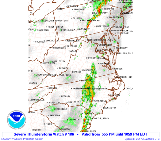
Severe Thunderstorm Watch Number 186
NWS Storm Prediction Center Norman OK
555 PM EDT Mon May 1 2017
The NWS Storm Prediction Center has issued a
* Severe Thunderstorm Watch for portions of
District Of Columbia
Northern Maryland
Central North Carolina
South central Pennsylvania
Central and northern Virginia
The eastern West Virginia Panhandle
Coastal Waters
* Effective this Monday afternoon and evening from 555 PM until
1100 PM EDT.
* Primary threats include...
Scattered damaging wind gusts to 70 mph possible
Isolated large hail events to 1 inch in diameter possible
SUMMARY...Broken bands of strong/severe storms will persist through
the evening with a primary risk for damaging winds, prior to the
convection weakening tonight.
The severe thunderstorm watch area is approximately along and 65
statute miles east and west of a line from 30 miles northeast of
Martinsburg WV to 25 miles west southwest of Southern Pines NC. For
a complete depiction of the watch see the associated watch outline
update (WOUS64 KWNS WOU6).
PRECAUTIONARY/PREPAREDNESS ACTIONS...
REMEMBER...A Severe Thunderstorm Watch means conditions are
favorable for severe thunderstorms in and close to the watch area.
Persons in these areas should be on the lookout for threatening
weather conditions and listen for later statements and possible
warnings. Severe thunderstorms can and occasionally do produce
tornadoes.
&&
OTHER WATCH INFORMATION...CONTINUE...WW 185...
AVIATION...A few severe thunderstorms with hail surface and aloft to
1 inch. Extreme turbulence and surface wind gusts to 60 knots. A few
cumulonimbi with maximum tops to 450. Mean storm motion vector
24040.
...Thompson

   SEL6

   URGENT - IMMEDIATE BROADCAST REQUESTED
   Severe Thunderstorm Watch Number 186
   NWS Storm Prediction Center Norman OK
   555 PM EDT Mon May 1 2017

   The NWS Storm Prediction Center has issued a

   * Severe Thunderstorm Watch for portions of
     District Of Columbia
     Northern Maryland
     Central North Carolina
     South central Pennsylvania
     Central and northern Virginia
     The eastern West Virginia Panhandle
     Coastal Waters

   * Effective this Monday afternoon and evening from 555 PM until
     1100 PM EDT.

   * Primary threats include...
     Scattered damaging wind gusts to 70 mph possible
     Isolated large hail events to 1 inch in diameter possible

   SUMMARY...Broken bands of strong/severe storms will persist through
   the evening with a primary risk for damaging winds, prior to the
   convection weakening tonight.

   The severe thunderstorm watch area is approximately along and 65
   statute miles east and west of a line from 30 miles northeast of
   Martinsburg WV to 25 miles west southwest of Southern Pines NC. For
   a complete depiction of the watch see the associated watch outline
   update (WOUS64 KWNS WOU6).

   PRECAUTIONARY/PREPAREDNESS ACTIONS...

   REMEMBER...A Severe Thunderstorm Watch means conditions are
   favorable for severe thunderstorms in and close to the watch area.
   Persons in these areas should be on the lookout for threatening
   weather conditions and listen for later statements and possible
   warnings. Severe thunderstorms can and occasionally do produce
   tornadoes.

   &&

   OTHER WATCH INFORMATION...CONTINUE...WW 185...

   AVIATION...A few severe thunderstorms with hail surface and aloft to
   1 inch. Extreme turbulence and surface wind gusts to 60 knots. A few
   cumulonimbi with maximum tops to 450. Mean storm motion vector
   24040.

   ...Thompson
 Note:
The Aviation Watch (SAW) product is an approximation to the watch area.
The actual watch is depicted by the shaded areas.
Note:
The Aviation Watch (SAW) product is an approximation to the watch area.
The actual watch is depicted by the shaded areas.
   SAW6
   WW 186 SEVERE TSTM DC MD NC PA VA WV CW 012155Z - 020300Z
   AXIS..65 STATUTE MILES EAST AND WEST OF LINE..
   30NE MRB/MARTINSBURG WV/ - 25WSW SOP/SOUTHERN PINES NC/
   ..AVIATION COORDS.. 55NM E/W /30WNW EMI - 51N FLO/
   HAIL SURFACE AND ALOFT..1 INCH. WIND GUSTS..60 KNOTS.
   MAX TOPS TO 450. MEAN STORM MOTION VECTOR 24040.

   LAT...LON 39707636 35087863 35088094 39707880

   THIS IS AN APPROXIMATION TO THE WATCH AREA.  FOR A
   COMPLETE DEPICTION OF THE WATCH SEE WOUS64 KWNS
   FOR WOU6.
Watch 186 Status Report Messages:
STATUS REPORT #2 ON WW 186

VALID 020035Z - 020140Z

SEVERE WEATHER THREAT CONTINUES RIGHT OF A LINE FROM 15 SW SOP TO
40 ENE DAN TO 20 E CHO TO 35 WSW NHK.

FOR ADDITIONAL INFORMATION SEE MESOSCALE DISCUSSION 629.

..LEITMAN..05/02/17

ATTN...WFO...LWX...RAH...RNK...CTP...AKQ...

&&

STATUS REPORT FOR WS 186

SEVERE WEATHER THREAT CONTINUES FOR THE FOLLOWING AREAS

NCC037-063-069-077-085-093-105-125-165-181-183-185-020140-

NC
.    NORTH CAROLINA COUNTIES INCLUDED ARE

CHATHAM 	     DURHAM		 FRANKLIN
GRANVILLE	     HARNETT		 HOKE
LEE		     MOORE		 SCOTLAND
VANCE		     WAKE		 WARREN
$$


PAC001-041-043-055-071-075-099-107-133-020140-

PA
.    PENNSYLVANIA COUNTIES INCLUDED ARE

ADAMS		     CUMBERLAND 	 DAUPHIN
FRANKLIN	     LANCASTER		 LEBANON
PERRY		     SCHUYLKILL 	 YORK
$$


VAC007-025-033-041-049-053-075-085-087-109-111-117-135-145-147-
760-020140-

VA
.    VIRGINIA COUNTIES INCLUDED ARE

AMELIA		     BRUNSWICK		 CAROLINE
CHESTERFIELD	     CUMBERLAND 	 DINWIDDIE
GOOCHLAND	     HANOVER		 HENRICO
LOUISA		     LUNENBURG		 MECKLENBURG
NOTTOWAY	     POWHATAN		 PRINCE EDWARD


VIRGINIA INDEPENDENT CITIES INCLUDED ARE

RICHMOND
$$


THE WATCH STATUS MESSAGE IS FOR GUIDANCE PURPOSES ONLY.  PLEASE
REFER TO WATCH COUNTY NOTIFICATION STATEMENTS FOR OFFICIAL
INFORMATION ON COUNTIES...INDEPENDENT CITIES AND MARINE ZONES
CLEARED FROM SEVERE THUNDERSTORM AND TORNADO WATCHES.
$$

STATUS REPORT #1 ON WW 186

VALID 012330Z - 020040Z

SEVERE WEATHER THREAT CONTINUES RIGHT OF A LINE FROM 45 WSW SOP
TO 25 SSW DAN TO 15 E LYH TO 35 WSW SHD.

..LEITMAN..05/01/17

ATTN...WFO...LWX...RAH...RNK...CTP...AKQ...

&&

STATUS REPORT FOR WS 186

SEVERE WEATHER THREAT CONTINUES FOR THE FOLLOWING AREAS

DCC001-020040-

DC
.    DISTRICT OF COLUMBIA COUNTIES INCLUDED ARE

DISTRICT OF COLUMBIA
$$


MDC001-005-013-017-021-025-027-031-033-043-510-020040-

MD
.    MARYLAND COUNTIES INCLUDED ARE

ALLEGANY	     BALTIMORE		 CARROLL
CHARLES 	     FREDERICK		 HARFORD
HOWARD		     MONTGOMERY 	 PRINCE GEORGES
WASHINGTON


MARYLAND INDEPENDENT CITIES INCLUDED ARE

BALTIMORE CITY
$$


NCC001-037-063-069-077-085-093-105-125-135-145-153-165-181-183-
185-020040-

NC
.    NORTH CAROLINA COUNTIES INCLUDED ARE

ALAMANCE	     CHATHAM		 DURHAM
FRANKLIN	     GRANVILLE		 HARNETT
HOKE		     LEE		 MOORE
ORANGE		     PERSON		 RICHMOND
SCOTLAND	     VANCE		 WAKE
WARREN
$$


PAC001-041-043-055-071-075-099-107-133-020040-

PA
.    PENNSYLVANIA COUNTIES INCLUDED ARE

ADAMS		     CUMBERLAND 	 DAUPHIN
FRANKLIN	     LANCASTER		 LEBANON
PERRY		     SCHUYLKILL 	 YORK
$$


VAC003-007-011-013-015-025-029-031-033-037-041-043-047-049-053-
059-061-065-069-075-079-083-085-087-091-099-107-109-111-113-117-
125-135-137-139-145-147-153-157-165-171-177-179-187-510-540-600-
610-630-660-683-685-760-790-820-840-020040-

VA
.    VIRGINIA COUNTIES INCLUDED ARE

ALBEMARLE	     AMELIA		 APPOMATTOX
ARLINGTON	     AUGUSTA		 BRUNSWICK
BUCKINGHAM	     CAMPBELL		 CAROLINE
CHARLOTTE	     CHESTERFIELD	 CLARKE
CULPEPER	     CUMBERLAND 	 DINWIDDIE
FAIRFAX 	     FAUQUIER		 FLUVANNA
FREDERICK	     GOOCHLAND		 GREENE
HALIFAX 	     HANOVER		 HENRICO
HIGHLAND	     KING GEORGE	 LOUDOUN
LOUISA		     LUNENBURG		 MADISON
MECKLENBURG	     NELSON		 NOTTOWAY
ORANGE		     PAGE		 POWHATAN
PRINCE EDWARD	     PRINCE WILLIAM	 RAPPAHANNOCK
ROCKINGHAM	     SHENANDOAH 	 SPOTSYLVANIA
STAFFORD	     WARREN


VIRGINIA INDEPENDENT CITIES INCLUDED ARE

ALEXANDRIA	     CHARLOTTESVILLE	 FAIRFAX
FALLS CHURCH	     FREDERICKSBURG	 HARRISONBURG
MANASSAS	     MANASSAS PARK	 RICHMOND
STAUNTON	     WAYNESBORO 	 WINCHESTER
$$


WVC003-023-027-031-037-057-065-071-020040-

WV
.    WEST VIRGINIA COUNTIES INCLUDED ARE

BERKELEY	     GRANT		 HAMPSHIRE
HARDY		     JEFFERSON		 MINERAL
MORGAN		     PENDLETON
$$


ANZ530-531-535-536-538-020040-

CW

.    ADJACENT COASTAL WATERS INCLUDED ARE

CHESAPEAKE BAY NORTH OF POOLES ISLAND MD

CHESAPEAKE BAY FROM POOLES ISLAND TO SANDY POINT MD

TIDAL POTOMAC FROM KEY BRIDGE TO INDIAN HEAD MD

TIDAL POTOMAC FROM INDIAN HEAD TO COBB ISLAND MD

PATAPSCO RIVER INCLUDING BALTIMORE HARBOR

$$
THE WATCH STATUS MESSAGE IS FOR GUIDANCE PURPOSES ONLY.  PLEASE
REFER TO WATCH COUNTY NOTIFICATION STATEMENTS FOR OFFICIAL
INFORMATION ON COUNTIES...INDEPENDENT CITIES AND MARINE ZONES
CLEARED FROM SEVERE THUNDERSTORM AND TORNADO WATCHES.
$$
Note:
Click for Complete Product Text.
Tornadoes
Probability of 2 or more tornadoes
|
Low (10%)
|
Probability of 1 or more strong (F2-F5) tornadoes
|
Low (<2%)
|
Wind
Probability of 10 or more severe wind events
|
Mod (40%)
|
Probability of 1 or more wind events > 65 knots
|
Low (10%)
|
Hail
Probability of 10 or more severe hail events
|
Low (20%)
|
Probability of 1 or more hailstones > 2 inches
|
Low (10%)
|
Combined Severe Hail/Wind
Probability of 6 or more combined severe hail/wind events
|
High (70%)
|
For each watch, probabilities for particular events inside the watch
(listed above in each table) are determined by the issuing forecaster.
The "Low" category contains probability values ranging from less than 2%
to 20% (F2-F5 tornadoes), less than 5% to 20% (all other probabilities),
"Moderate" from 30% to 60%, and "High" from 70% to greater than 95%.
High values are bolded and lighter in color to provide awareness of
an increased threat for a particular event.


 @NWSSPC


