|
Initial List of Counties in SPC Severe Thunderstorm Watch 353 (WOU)
|
Back to Watch 353
|
 |
WOUS64 KWNS 241148
WOU3
BULLETIN - IMMEDIATE BROADCAST REQUESTED
SEVERE THUNDERSTORM WATCH OUTLINE UPDATE FOR WS 353
NWS STORM PREDICTION CENTER NORMAN OK
650 AM CDT TUE MAY 24 2011
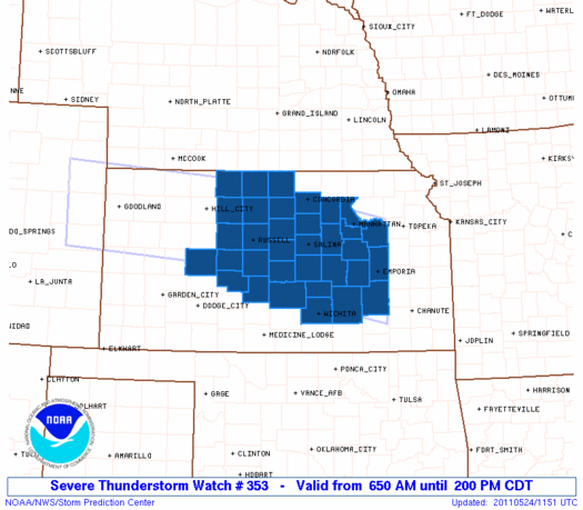
SEVERE THUNDERSTORM WATCH 353 IS IN EFFECT UNTIL 200 PM CDT
FOR THE FOLLOWING LOCATIONS
KSC009-015-017-027-029-041-051-053-061-073-079-089-105-111-113-
115-123-127-135-141-143-145-147-155-159-161-163-165-167-169-173-
183-185-197-241900-
/O.NEW.KWNS.SV.A.0353.110524T1150Z-110524T1900Z/
KS
. KANSAS COUNTIES INCLUDED ARE
BARTON BUTLER CHASE
CLAY CLOUD DICKINSON
ELLIS ELLSWORTH GEARY
GREENWOOD HARVEY JEWELL
LINCOLN LYON MARION
MCPHERSON MITCHELL MORRIS
NESS OSBORNE OTTAWA
PAWNEE PHILLIPS RENO
RICE RILEY ROOKS
RUSH RUSSELL SALINE
SEDGWICK SMITH STAFFORD
WABAUNSEE
ATTN...WFO...ICT...TOP...DDC...GID...
|
| Aviation Watch (SAW) for WW353 |
|---|
 |
| Note:
The Aviation Watch (SAW) product is an approximation to the watch area.
The actual watch is depicted by the shaded areas. |
   SAW3
   WW 353 SEVERE TSTM KS 241150Z - 241900Z
   AXIS..60 STATUTE MILES NORTH AND SOUTH OF LINE..
   30WNW RSL/RUSSELL KS/ - 10E EMP/EMPORIA KS/
   ..AVIATION COORDS.. 50NM N/S /44ESE HLC - 71W BUM/
   HAIL SURFACE AND ALOFT..2 INCHES. WIND GUSTS..60 KNOTS.
   MAX TOPS TO 450. MEAN STORM MOTION VECTOR 27025.

   LAT...LON 39889933 39209600 37459600 38159933

   THIS IS AN APPROXIMATION TO THE WATCH AREA.  FOR A
   COMPLETE DEPICTION OF THE WATCH SEE WOUS64 KWNS
   FOR WOU3.
|
|


 @NWSSPC
