|
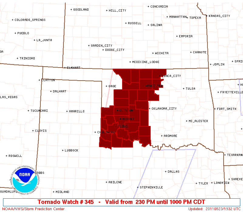
Initial List of Counties in SPC Tornado Watch 345 (WOU)
|
Back to Watch 345
|
 |
   WOUS64 KWNS 231927
   WOU5

   BULLETIN - IMMEDIATE BROADCAST REQUESTED
   TORNADO WATCH OUTLINE UPDATE FOR WT 345
   NWS STORM PREDICTION CENTER NORMAN OK
   230 PM CDT MON MAY 23 2011

   TORNADO WATCH 345 IS IN EFFECT UNTIL 1000 PM CDT FOR THE
    FOLLOWING LOCATIONS

   OKC003-009-011-015-017-031-033-039-043-047-051-053-055-057-065-
   067-071-073-075-083-093-103-137-141-149-151-240300-
   /O.NEW.KWNS.TO.A.0345.110523T1930Z-110524T0300Z/

   OK
   .    OKLAHOMA COUNTIES INCLUDED ARE

   ALFALFA              BECKHAM             BLAINE
   CADDO                CANADIAN            COMANCHE
   COTTON               CUSTER              DEWEY
   GARFIELD             GRADY               GRANT
   GREER                HARMON              JACKSON
   JEFFERSON            KAY                 KINGFISHER
   KIOWA                LOGAN               MAJOR
   NOBLE                STEPHENS            TILLMAN
   WASHITA              WOODS


   TXC155-197-485-487-240300-
   /O.NEW.KWNS.TO.A.0345.110523T1930Z-110524T0300Z/

   TX
   .    TEXAS COUNTIES INCLUDED ARE

   FOARD                HARDEMAN            WICHITA
   WILBARGER


   ATTN...WFO...OUN...
|
| Aviation Watch (SAW) for WW345 |
|---|
 |
| Note:
The Aviation Watch (SAW) product is an approximation to the watch area.
The actual watch is depicted by the shaded areas. |
   SAW5
   WW 345 TORNADO OK TX 231930Z - 240300Z
   AXIS..60 STATUTE MILES EAST AND WEST OF LINE..
   25NE AVK/ALVA OK/ - 40SSE LTS/ALTUS OK/
   ..AVIATION COORDS.. 50NM E/W /46NNW END - 22WNW SPS/
   HAIL SURFACE AND ALOFT..3 INCHES. WIND GUSTS..60 KNOTS.
   MAX TOPS TO 600. MEAN STORM MOTION VECTOR 27020.

   LAT...LON 37029726 34119794 34110005 37029944

   THIS IS AN APPROXIMATION TO THE WATCH AREA.  FOR A
   COMPLETE DEPICTION OF THE WATCH SEE WOUS64 KWNS
   FOR WOU5.
|
|


 @NWSSPC