|
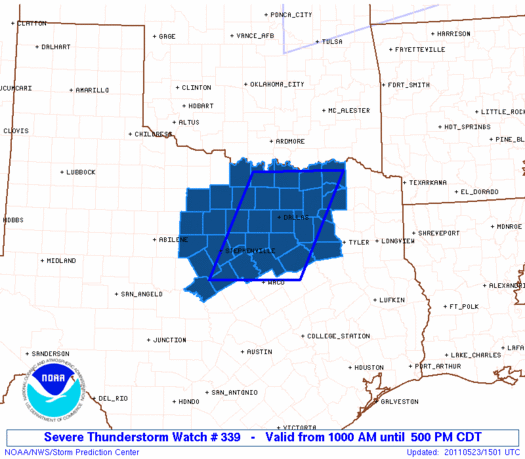
Initial List of Counties in SPC Severe Thunderstorm Watch 339 (WOU)
|
Back to Watch 339
|
 |
   WOUS64 KWNS 231456
   WOU9

   BULLETIN - IMMEDIATE BROADCAST REQUESTED
   SEVERE THUNDERSTORM WATCH OUTLINE UPDATE FOR WS 339
   NWS STORM PREDICTION CENTER NORMAN OK
   1000 AM CDT MON MAY 23 2011

   SEVERE THUNDERSTORM WATCH 339 IS IN EFFECT UNTIL 500 PM CDT
   FOR THE FOLLOWING LOCATIONS

   TXC035-085-093-097-113-119-121-133-139-143-147-181-193-213-217-
   221-223-231-237-251-257-277-333-337-349-363-367-379-397-425-429-
   439-467-497-503-232200-
   /O.NEW.KWNS.SV.A.0339.110523T1500Z-110523T2200Z/

   TX
   .    TEXAS COUNTIES INCLUDED ARE

   BOSQUE               COLLIN              COMANCHE
   COOKE                DALLAS              DELTA
   DENTON               EASTLAND            ELLIS
   ERATH                FANNIN              GRAYSON
   HAMILTON             HENDERSON           HILL
   HOOD                 HOPKINS             HUNT
   JACK                 JOHNSON             KAUFMAN
   LAMAR                MILLS               MONTAGUE
   NAVARRO              PALO PINTO          PARKER
   RAINS                ROCKWALL            SOMERVELL
   STEPHENS             TARRANT             VAN ZANDT
   WISE                 YOUNG


   ATTN...WFO...FWD...
|
| Aviation Watch (SAW) for WW339 |
|---|
 |
| Note:
The Aviation Watch (SAW) product is an approximation to the watch area.
The actual watch is depicted by the shaded areas. |
   SAW9
   WW 339 SEVERE TSTM TX 231500Z - 232200Z
   AXIS..60 STATUTE MILES EAST AND WEST OF LINE..
   15E GYI/SHERMAN TX/ - 65WSW CRS/CORSICANA TX/
   ..AVIATION COORDS.. 50NM E/W /48SE ADM - 8W ACT/
   HAIL SURFACE AND ALOFT..2.5 INCHES. WIND GUSTS..60 KNOTS.
   MAX TOPS TO 600. MEAN STORM MOTION VECTOR 28020.

   LAT...LON 33729537 31659640 31659844 33729744

   THIS IS AN APPROXIMATION TO THE WATCH AREA.  FOR A
   COMPLETE DEPICTION OF THE WATCH SEE WOUS64 KWNS
   FOR WOU9.
|
|


 @NWSSPC
