|
Initial List of Counties in SPC Severe Thunderstorm Watch 329 (WOU)
|
Back to Watch 329
|
 |
WOUS64 KWNS 221945
WOU9
BULLETIN - IMMEDIATE BROADCAST REQUESTED
SEVERE THUNDERSTORM WATCH OUTLINE UPDATE FOR WS 329
NWS STORM PREDICTION CENTER NORMAN OK
250 PM CDT SUN MAY 22 2011
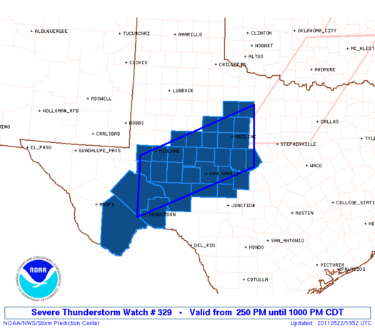
SEVERE THUNDERSTORM WATCH 329 IS IN EFFECT UNTIL 1000 PM CDT
FOR THE FOLLOWING LOCATIONS
TXC043-049-059-081-083-095-103-105-135-151-173-207-227-235-253-
307-327-329-335-353-371-383-399-413-417-431-441-443-447-451-461-
230300-
/O.NEW.KWNS.SV.A.0329.110522T1950Z-110523T0300Z/
TX
. TEXAS COUNTIES INCLUDED ARE
BREWSTER BROWN CALLAHAN
COKE COLEMAN CONCHO
CRANE CROCKETT ECTOR
FISHER GLASSCOCK HASKELL
HOWARD IRION JONES
MCCULLOCH MENARD MIDLAND
MITCHELL NOLAN PECOS
REAGAN RUNNELS SCHLEICHER
SHACKELFORD STERLING TAYLOR
TERRELL THROCKMORTON TOM GREEN
UPTON
ATTN...WFO...MAF...SJT...
|
| Aviation Watch (SAW) for WW329 |
|---|
 |
| Note:
The Aviation Watch (SAW) product is an approximation to the watch area.
The actual watch is depicted by the shaded areas. |
   SAW9
   WW 329 SEVERE TSTM TX 221950Z - 230300Z
   AXIS..60 STATUTE MILES NORTH AND SOUTH OF LINE..
   45N BWD/BROWNWOOD TX/ - 75SSW MAF/MIDLAND TX/
   ..AVIATION COORDS.. 50NM N/S /46E ABI - 15E FST/
   HAIL SURFACE AND ALOFT..3 INCHES. WIND GUSTS..60 KNOTS.
   MAX TOPS TO 600. MEAN STORM MOTION VECTOR 27020.

   LAT...LON 31579894 30070268 31800268 33319894

   THIS IS AN APPROXIMATION TO THE WATCH AREA.  FOR A
   COMPLETE DEPICTION OF THE WATCH SEE WOUS64 KWNS
   FOR WOU9.
|
|


 @NWSSPC
