|
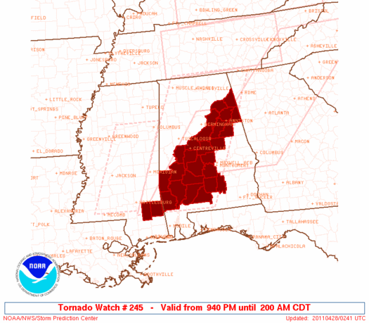
Initial List of Counties in SPC Tornado Watch 245 (WOU)
|
Back to Watch 245
|
 |
   WOUS64 KWNS 280238
   WOU5

   BULLETIN - IMMEDIATE BROADCAST REQUESTED
   TORNADO WATCH OUTLINE UPDATE FOR WT 245
   NWS STORM PREDICTION CENTER NORMAN OK
   940 PM CDT WED APR 27 2011

   TORNADO WATCH 245 IS IN EFFECT UNTIL 200 AM CDT FOR THE
    FOLLOWING LOCATIONS

   ALC001-007-013-015-019-021-023-025-027-029-035-037-041-047-055-
   065-085-091-099-105-115-117-121-129-131-280700-
   /O.NEW.KWNS.TO.A.0245.110428T0240Z-110428T0700Z/

   AL
   .    ALABAMA COUNTIES INCLUDED ARE

   AUTAUGA              BIBB                BUTLER
   CALHOUN              CHEROKEE            CHILTON
   CHOCTAW              CLARKE              CLAY
   CLEBURNE             CONECUH             COOSA
   CRENSHAW             DALLAS              ETOWAH
   HALE                 LOWNDES             MARENGO
   MONROE               PERRY               SHELBY
   ST. CLAIR            TALLADEGA           WASHINGTON
   WILCOX


   MSC041-111-280700-
   /O.NEW.KWNS.TO.A.0245.110428T0240Z-110428T0700Z/

   MS
   .    MISSISSIPPI COUNTIES INCLUDED ARE

   GREENE               PERRY


   ATTN...WFO...BMX...MOB...
|
| Aviation Watch (SAW) for WW245 |
|---|
 |
| Note:
The Aviation Watch (SAW) product is an approximation to the watch area.
The actual watch is depicted by the shaded areas. |
   SAW5
   WW 245 TORNADO AL MS 280240Z - 280700Z
   AXIS..45 STATUTE MILES EAST AND WEST OF LINE..
   GAD/GADSDEN AL/ - 105SW SEM/SELMA AL/
   ..AVIATION COORDS.. 40NM E/W /45ENE VUZ - 33N SJI/
   HAIL SURFACE AND ALOFT..1.5 INCHES. WIND GUSTS..60 KNOTS.
   MAX TOPS TO 500. MEAN STORM MOTION VECTOR 24040.

   LAT...LON 33978529 31278748 31278900 33978687

   THIS IS AN APPROXIMATION TO THE WATCH AREA.  FOR A
   COMPLETE DEPICTION OF THE WATCH SEE WOUS64 KWNS
   FOR WOU5.
|
|


 @NWSSPC
