|
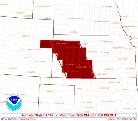
Initial List of Counties in SPC Tornado Watch 146 (WOU)
|
Back to Watch 146
|
 |
   WOUS64 KWNS 101733
   WOU6

   BULLETIN - IMMEDIATE BROADCAST REQUESTED
   TORNADO WATCH OUTLINE UPDATE FOR WT 146
   NWS STORM PREDICTION CENTER NORMAN OK
   1235 PM CDT MON MAY 10 2010

   TORNADO WATCH 146 IS IN EFFECT UNTIL 700 PM CDT FOR THE
    FOLLOWING LOCATIONS

   COC063-110000-
   /O.NEW.KWNS.TO.A.0146.100510T1735Z-100511T0000Z/

   CO
   .    COLORADO COUNTIES INCLUDED ARE

   KIT CARSON


   KSC007-025-033-047-051-055-057-063-065-069-081-083-097-101-109-
   119-135-145-151-165-171-179-181-185-193-195-199-203-110000-
   /O.NEW.KWNS.TO.A.0146.100510T1735Z-100511T0000Z/

   KS
   .    KANSAS COUNTIES INCLUDED ARE

   BARBER               CLARK               COMANCHE
   EDWARDS              ELLIS               FINNEY
   FORD                 GOVE                GRAHAM
   GRAY                 HASKELL             HODGEMAN
   KIOWA                LANE                LOGAN
   MEADE                NESS                PAWNEE
   PRATT                RUSH                SCOTT
   SHERIDAN             SHERMAN             STAFFORD
   THOMAS               TREGO               WALLACE
   WICHITA


   ATTN...WFO...GLD...DDC...
|
| Aviation Watch (SAW) for WW146 |
|---|
 |
| Note:
The Aviation Watch (SAW) product is an approximation to the watch area.
The actual watch is depicted by the shaded areas. |
   SAW6
   WW 146 TORNADO CO KS 101735Z - 110000Z
   AXIS..70 STATUTE MILES EAST AND WEST OF LINE..
   40ENE GLD/GOODLAND KS/ - 50WSW P28/MEDICINE LODGE KS/
   ..AVIATION COORDS.. 60NM E/W /34ENE GLD - 46NNE GAG/
   HAIL SURFACE AND ALOFT..2 INCHES. WIND GUSTS..60 KNOTS.
   MAX TOPS TO 500. MEAN STORM MOTION VECTOR 24035.

   LAT...LON 39569969 37009815 37000069 39560231

   THIS IS AN APPROXIMATION TO THE WATCH AREA.  FOR A
   COMPLETE DEPICTION OF THE WATCH SEE WOUS64 KWNS
   FOR WOU6.
|
|


 @NWSSPC
