Madison, WI...Des Moines, IA...Rockford, IL...Cedar Rapids, IA...Green Bay, WI...
5 %
163,309
13,336,275
Milwaukee, WI...Oklahoma City, OK...Kansas City, MO...Omaha, NE...Wichita, KS...
2 %
154,505
10,826,671
Chicago, IL...Tulsa, OK...Lincoln, NE...Sioux Falls, SD...Joliet, IL...
Probabilistic Damaging Wind Graphic
Probability of damaging thunderstorm winds or wind gusts of 50 knots or higher within 25 miles of a point. Hatched Area: 10% of greater probability of wind gusts 65 knots or greater within 25 miles of a point.
Day 2 Wind Risk
Area (sq. mi.)
Area Pop.
Some Larger Population Centers in Risk Area
30 %
80,277
6,516,326
Minneapolis, MN...St. Paul, MN...Green Bay, WI...Rochester, MN...Bloomington, MN...
15 %
285,808
25,440,856
Chicago, IL...Milwaukee, WI...Oklahoma City, OK...Kansas City, MO...Tulsa, OK...
Probability of hail 1" or larger within 25 miles of a point. Hatched Area: 10% or greater probability of hail 2" or larger within 25 miles of a point.
Day 2 Hail Risk
Area (sq. mi.)
Area Pop.
Some Larger Population Centers in Risk Area
SIG SEVERE
273,395
18,762,656
Oklahoma City, OK...Kansas City, MO...Omaha, NE...Minneapolis, MN...Wichita, KS...
30 %
189,843
14,155,544
Kansas City, MO...Omaha, NE...Minneapolis, MN...St. Paul, MN...Madison, WI...
15 %
260,764
21,530,525
Chicago, IL...Milwaukee, WI...Oklahoma City, OK...Tulsa, OK...Wichita, KS...
5 %
174,644
8,874,700
St. Louis, MO...Lubbock, TX...Grand Rapids, MI...Springfield, MO...Springfield, IL...
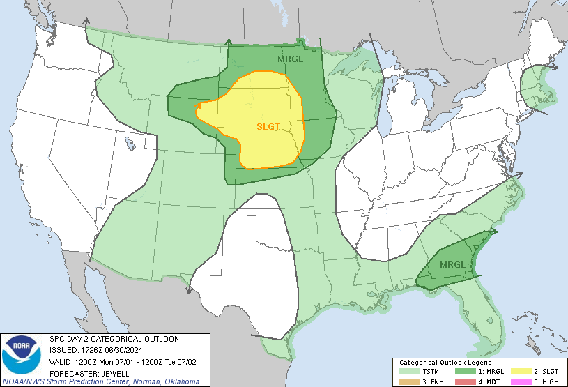
   SPC AC 271733

   Day 2 Convective Outlook
   NWS Storm Prediction Center Norman OK
   1233 PM CDT Sun Apr 27 2025

   Valid 281200Z - 291200Z

   ...THERE IS A MODERATE RISK OF SEVERE THUNDERSTORMS IN SOUTHERN
   MN/NORTHERN IA/WESTERN WI...

   ...SUMMARY...
   Multiple corridors of severe thunderstorms are expected across the
   Upper Midwest on Monday into Monday night, with a regional severe
   weather outbreak possible. The most dangerous period is likely
   during the late afternoon and evening when strong tornado potential
   should be maximized. Scattered large to very large hail and damaging
   winds are likely as well.

   ...Synopsis...
   A positive-tilt, upper-level trough will consist of multiple
   embedded shortwave impulses, moving east-northeast from the central
   High Plains to the Upper Midwest. A belt of 70+ kt 500-mb
   southwesterlies will be present from the central Great Plains to the
   Upper MS Valley on Monday afternoon. Primary surface cyclone should
   deepen slightly during the day as it advances from eastern SD to the
   Upper Great Lakes. A dryline will extend from the Mid-MO Valley
   south-southwest into west TX. A cold front will overtake the dryline
   as it surges southeast Monday night.

   ...Upper Midwest...
   After coordination with affected WFOs, primary adjustments have
   occurred along the southern extent of the severe probabilities to
   account for a more conditional, but still potentially significant
   severe threat.

   An arc of elevated thunderstorms will be ongoing at 12Z Monday from
   ND across the Upper MS Valley. Isolated large hail will be possible
   with these morning storms as they move east-northeast. Additional
   elevated storms will redevelop towards midday/early afternoon to the
   northeast of the aforementioned surface low. This will slow the
   advancement of the surface warm front into central MN, but
   strengthen differential surface heating across the baroclinic zone,
   with greater warming nosing north from NE into southeast SD.
   Surface-based storm development should occur by mid-afternoon across
   a portion of the Mid-MO Valley into southwest/west-central MN along
   the dryline to surface low. Large hail should be the primary initial
   threat, but cells may congeal into linear clusters, especially
   near/across the warm front. A mix of hail/wind/embedded tornadoes is
   likely, with the latter increasing with southern/eastern extent
   during late afternoon owing to stronger low-level shear across
   southeast MN/northeast IA into western WI.

   Open warm-sector storm development ahead of the dryline is nebulous
   with low confidence on the degree of ascent ahead of the dryline
   given the synoptic setup. Conditionally, both the buoyancy/shear
   parameter space is volatile and supportive of potential for multiple
   long-track, tornadic supercells. Timing of mid-level height falls
   tends to favor the evening period after peak heating but CAM
   signals, outside of the 12Z FV3, are sparse. Greater large-scale
   ascent appears focused from far northeast IA into WI. This region
   remains the most favorable for discrete warm-sector development
   during the evening. Otherwise, upstream linear clusters from
   southern/eastern MN will likely spread across northern/central WI
   into parts of Upper MI with a mixed mode of all hazards persisting,
   before eventually weakening overnight.

   ...Eastern KS/northern MO to west TX...
   Overall forcing will be weaker farther south along the dryline, but
   subtle mid-level height falls across a mostly uncapped warm sector
   should result in isolated to scattered supercell development during
   the late afternoon to evening. This appears most likely across
   western north TX into southwest OK where greater boundary-layer
   heating and a nocturnally strengthening low-level jet are
   anticipated.

   ..Grams.. 04/27/2025

   NOTE: THE NEXT DAY 2 OUTLOOK IS SCHEDULED BY 0600Z