New York, NY...Jacksonville, FL...Pittsburgh, PA...Newark, NJ...Jersey City, NJ...
SPC AC 291927
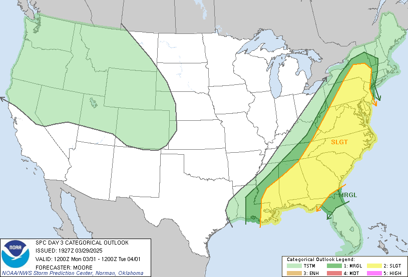
Day 3 Convective Outlook
NWS Storm Prediction Center Norman OK
0227 PM CDT Sat Mar 29 2025
Valid 311200Z - 011200Z
...THERE IS A SLIGHT RISK OF SEVERE THUNDERSTORMS ACROSS A LARGE
PART OF THE EASTERN U.S. INTO THE CENTRAL GULF COAST...
...SUMMARY...
Strong/severe thunderstorms are forecast Monday from portions of the
Northeast southwestward to the central Gulf Coast region.
...Synopsis...
A surface low is forecast to intensify as it moves northeastward
from the Lower Great Lakes into southeast Canada through the day
Monday morning in tandem with a leading shortwave trough. A trailing
cold front is expected to push east/southeast into the upper OH
River Valley and lower MS Valley/Southeast early Monday morning as a
second low-amplitude wave traverses the eastern CONUS. Thunderstorm
potential will be focused along this front as it continues to push
into New England, the Mid-Atlantic, and into the southeast states
through the late afternoon and evening hours.
...Central Gulf States...
Strong to severe thunderstorms may be ongoing by 12z Monday as a
squall line forced along the cold front continues to push southeast
across MS and AL. A combination of rich low-level moisture ahead of
the line, diurnal heating, strong low to mid-level flow, and broad
scale ascent ahead of the secondary upper wave should help maintain
convective intensity into the afternoon hours. A corridor of
damaging/severe winds, and potentially embedded tornadoes, appears
probable from central MS into AL and western GA.
...Central Appalachians...
Thunderstorm development along the front is expected by early to
mid-afternoon from the upper OH Valley southward into the
Mid-Atlantic region. Returning moisture through the Carolinas
northward into eastern PA/western NY, combined with mid-level lapse
rates around 7 C/km, should support sufficient buoyancy for deep
convection, though buoyancy values should diminish with northward
extent across the central Appalachians. Moderate flow within the
lowest few kilometers should support a damaging wind threat as
convection matures along the front across the upper OH Valley.
Further south, stronger ascent ahead of the secondary upper wave
should promote better storm organization, including the potential
for semi-discrete cells and/or organized linear segments.
Medium-range guidance suggests low-level winds will strengthen
across the Mid-Atlantic region as a weak secondary low deepens
through late afternoon in the lee of the Appalachians, which may
support an enlargement of the 0-3 km hodograph and a locally higher
tornado threat across the Carolinas into VA.
..Moore.. 03/29/2025
CLICK TO GET WUUS03 PTSDY3 PRODUCT
NOTE: THE NEXT DAY 3 OUTLOOK IS SCHEDULED BY 0730Z