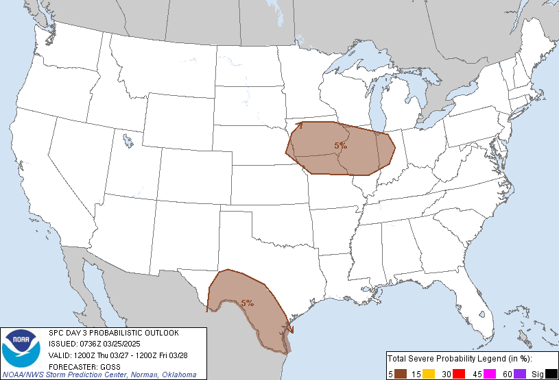
Kansas City, MO...Omaha, NE...St. Louis, MO...Corpus Christi, TX...Lincoln, NE...
Probabilistic Graphic
Probability of severe weather within 25 miles of a point. Hatched Area: 10% or greater probability of significant severe within 25 miles of a point.
Day 3 Prob. Risk
Area (sq. mi.)
Area Pop.
Some Larger Population Centers in Risk Area
5 %
166,277
12,068,419
Kansas City, MO...Omaha, NE...St. Louis, MO...Corpus Christi, TX...Lincoln, NE...
   SPC AC 250736

   Day 3 Convective Outlook
   NWS Storm Prediction Center Norman OK
   0236 AM CDT Tue Mar 25 2025

   Valid 271200Z - 281200Z

   ...THERE IS A MARGINAL RISK OF SEVERE THUNDERSTORMS ACROSS PARTS OF
   THE MID MISSOURI VALLEY AND MIDWEST...AND ACROSS PARTS OF WESTERN
   AND SOUTHERN TEXAS...

   ...SUMMARY...
   A few strong/severe storms will be possible Thursday from the Mid
   Missouri Valley into the Ohio Valley, and across parts of western
   and southern Texas.

   ...Synopsis...
   Deamplification of the upper pattern across the U.S. is expected
   Thursday, as an eastern U.S. trough departs into the Atlantic, and
   deamplifying eastern Pacific troughing shifts into the West.
   Meanwhile, a weak southern-stream trough is forecast to cross
   northern Mexico and the southern Plains through Friday morning.

   At the surface, a cold front is expected to advance across the
   Intermountain West, associated with the filling/occluded low off the
   Pacific Northwest coast.  Meanwhile, a warm front is forecast to
   advance northward across the central U.S., and should extend from
   the northern Plains east-southeastward into the Ohio Valley by the
   end of the period.

   ...Portions of western and southern Texas, including the Rio Grande
   Valley...
   Afternoon heating will result in airmass destabilization across
   Texas, as cool air aloft associated with the southern-stream trough
   spreads across the region.  While flow aloft will remain modest,
   ample CAPE suggests a few stronger storms will be possible, with
   risk for hail and gusty/damaging winds.  Coverage of stronger
   convection should remain sparse, but enough to warrant introduction
   of 5%/MRGL risk for the afternoon and evening hours.

   ...Mid Missouri Valley across the Corn Belt...
   Low-level warm advection will be maximized near and north of a warm
   front advancing northward across the central CONUS.  Sufficiently
   steep mid-level lapse rates will support ample elevated CAPE,
   resulting in a zone of strong storm potential from eastern Nebraska
   east-southeastward to Indiana.  With west-northwesterly mid-level
   flow expected to average around 35 kt near the frontal zone,
   sufficient shear will exist to allow occasionally stronger storms to
   evolve -- a few capable of producing severe-caliber hail.

   ..Goss.. 03/25/2025

   CLICK TO GET WUUS03 PTSDY3 PRODUCT

   NOTE: THE NEXT DAY 3 OUTLOOK IS SCHEDULED BY 1930Z