SPC AC 210730
Day 3 Convective Outlook
NWS Storm Prediction Center Norman OK
0230 AM CDT Fri Mar 21 2025
Valid 231200Z - 241200Z
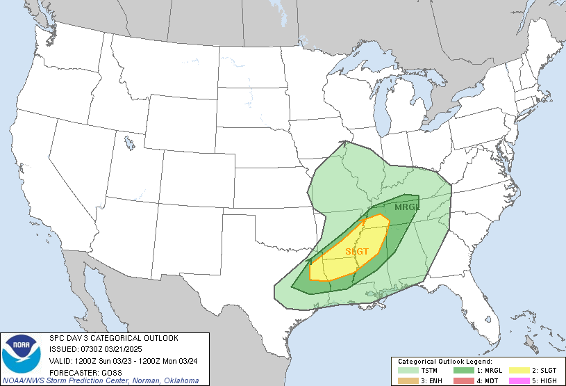
...THERE IS A SLIGHT RISK OF SEVERE THUNDERSTORMS FROM NORTHEASTERN
TEXAS TO WESTERN TENNESSEE/CENTRAL AND NORTHERN MISSISSIPPI...
...SUMMARY...
Afternoon storms from western Tennessee southwestward to
northeastern Texas may pose a risk for locally damaging winds and
hail.
...Synopsis...
A short-wave trough crossing the central/northern Plains is forecast
to evolve into a closed low, that is then progged to drift eastward
into the Upper Great Lakes region through the period. As this
occurs, a surface low -- initially over the Minnesota vicinity --
will become increasingly occluded, and likewise will drift eastward
into the Upper Great Lakes.
At the surface, a weak triple-point low is forecast to shift
northeastward across the Mid Mississippi/Ohio Valleys through the
day, while a cold front sags southward into western Kentucky/western
Tennessee/Arkansas/Texas. By the end of the period, this front
should extend from western Pennsylvania to the southern
Appalachians, and then westward into Texas.
...East Texas to the Tennessee Valley...
Daytime heating ahead of the cold front will combine with ample
warm-sector dewpoints to support airmass destabilization.
Mixed-layer CAPE ranging from around 500 J/kg in western Tennessee
to 1500 J/kg or so into eastern Texas seems likely evolve, and
should be sufficient to support development of scattered
strong/locally severe storms. Updraft intensity will be aided by
weakly veering/increasing flow with height through the mid
troposphere, with shear sufficient for organized/rotating updrafts.
While a tornado or two may be possible, greater risk appears to be
hail and locally damaging wind gusts. This risk should peak through
late afternoon, after which diurnal cooling/stabilization should
result in a gradual decrease in storm intensity/severe potential.
..Goss.. 03/21/2025
CLICK TO GET WUUS03 PTSDY3 PRODUCT
NOTE: THE NEXT DAY 3 OUTLOOK IS SCHEDULED BY 1930Z