Probability of damaging thunderstorm winds or wind gusts of 50 knots or higher within 25 miles of a point. Hatched Area: 10% of greater probability of wind gusts 65 knots or greater within 25 miles of a point.
Kansas City, MO...Omaha, NE...Wichita, KS...Lincoln, NE...Des Moines, IA...
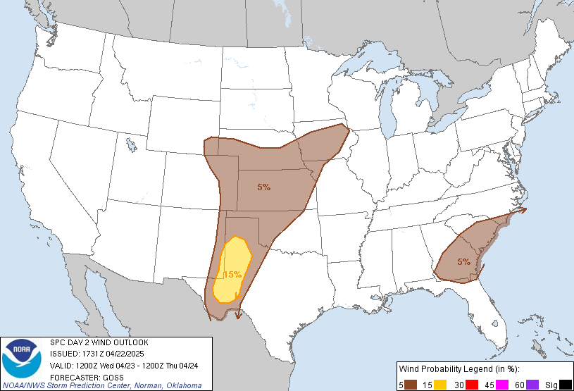
   SPC AC 221731

   Day 2 Convective Outlook
   NWS Storm Prediction Center Norman OK
   1231 PM CDT Tue Apr 22 2025

   Valid 231200Z - 241200Z

   ...THERE IS A SLIGHT RISK OF SEVERE THUNDERSTORMS ACROSS PORTIONS OF
   THE EASTERN NEW MEXICO AND ADJACENT PORTIONS OF THE TEXAS SOUTH
   PLAINS AND TRANSPECOS REGION...

   ...SUMMARY...
   Isolated severe thunderstorms are possible across portions of the
   central and southern High Plains on Wednesday.

   ...Central Plains to the southern High Plains...
   Moderate west-southwesterly flow aloft is forecast aloft across the
   Plains, with only weak/embedded disturbances within this flow field
   forecast to shift eastward across the Plains region.  Still, with
   the westerlies aloft maintaining weak lee troughing and potentially
   a weak low over the southeastern Colorado vicinity, low-level
   southerlies across the central/southern Plains will maintain a
   seasonably moist boundary layer.

   While convection and associated cloud cover ongoing early in the day
   -- particularly across the central Plains -- may hinder
   destabilization locally, afternoon insolation should support 1000 to
   2000 J/kg mixed-layer CAPE across a fairly broad area.  New storm
   development should occur across the Iowa/Nebraska Kansas area during
   the afternoon, though location/coverage will likely be modulated by
   aforementioned/earlier storms and associated outflows.  Where ample
   destabilization occurs, a few clusters of convection capable of
   producing locally strong/gusty winds and marginal hail can be
   expected.

   Greater severe risk -- associated with isolated supercell potential
   -- remains evident over the southern High Plains area and into the
   Transpecos region of Texas.  Here, a less perturbed airmass should
   heat/destabilize through the day, ahead of an evolving dryline.
   With modest but veering flow with height, shear should be sufficient
   to support mid-level rotation with stronger storms.  Large hail and
   locally damaging gusts will be the main risks with these storms.
   Some congealing/upscale growth may occur by early evening, as storms
   spread east-northeastward across parts of western Texas, but overall
   severe risk should gradually diminish diurnally.

   ...Parts of the Southeast...
   A weak mid-level vort max is forecast to be moving eastward across
   the central Gulf Coast region Wednesday afternoon, where a
   heating/destabilizing airmass is expected.  Fairly steep mid-level
   lapse rates should be present across the Georgia/South Carolina
   vicinity, which will contribute to development of 1500 to 2000 J/kg
   mixed-layer CAPE across this area.  While flow aloft will remain
   relatively weak, and thus storms generally rather disorganized, the
   degree of CAPE should support a few more vigorous updrafts.  Along
   with potential for marginal hail, a relatively deep mixed layer
   expected to evolve through peak heating could also promote some
   evaporative enhancement to downdrafts -- possibly yielding locally
   strong wind gusts from a few of the stronger storms.  Convection --
   and any ongoing severe risk -- will diminish after sunset.

   ..Goss.. 04/22/2025

   CLICK TO GET WUUS02 PTSDY2 PRODUCT

   NOTE: THE NEXT DAY 2 OUTLOOK IS SCHEDULED BY 0600Z