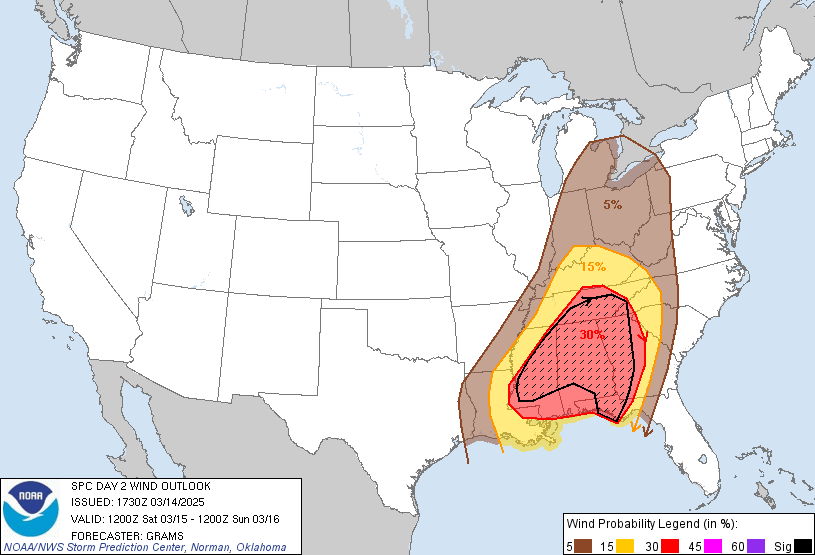
Probability of damaging thunderstorm winds or wind gusts of 50 knots or higher within 25 miles of a point. Hatched Area: 10% of greater probability of wind gusts 65 knots or greater within 25 miles of a point.
   SPC AC 141730

   Day 2 Convective Outlook
   NWS Storm Prediction Center Norman OK
   1230 PM CDT Fri Mar 14 2025

   Valid 151200Z - 161200Z

   ...THERE IS A HIGH RISK OF SEVERE THUNDERSTORMS IN CENTRAL/SOUTHERN
   PARTS OF MS/AL...

   ...SUMMARY...
   A tornado outbreak is likely on Saturday across the central Gulf
   Coast States and Deep South into the Tennessee Valley. Numerous
   significant tornadoes, some of which should be long-track and
   potentially violent, are expected on Saturday afternoon and evening.
   The most dangerous tornado threat should begin across eastern
   Louisiana and Mississippi during the late morning to afternoon,
   spread across Alabama late day into the evening, and reach western
   parts of the Florida Panhandle and Georgia Saturday night.

   ...Central Gulf Coast/Deep South/TN Valley...
   After collaboration with WFOs BMX/JAN/MOB, an upgrade to a level
   5-HIGH risk appears warranted for the most likely corridor of
   potentially violent tornadoes, peaking tomorrow afternoon and
   evening. A broader level 4-MDT risk has been expanded somewhat
   eastward for the nocturnal significant tornado threat.

   An intense mid-level jet, 100-110 kts at 500 mb, will eject through
   the basal portion of a broad southern Great Plains shortwave trough.
   This will induce secondary cyclogenesis along an initially
   slow-moving baroclinic zone from the Ark-La-Tex to the central Great
   Lakes. Another day of air mass modification ahead of this wave will
   yield a pronounced plume of rich northwest Gulf moisture that should
   be pristine across southeast LA and southern MS through late
   morning. As mid-level height falls overspread the diurnally warming
   air mass, increasing convective development is expected along the
   deepening baroclinic zone, as well as residual outflows to its
   northeast in the TN Valley from prior late D1 convection.

   Steep mid-level lapse rates atop the richly moist boundary layer
   will yield at least moderate MLCAPE from 1500-2500 J/kg across
   eastern LA into central MS. Vertically veering wind profiles with
   strong anvil-level divergence amid the favorable instability should
   support robust updrafts and intense supercells. Low-level shear will
   strengthen midday through the afternoon, yielding potential for a
   tornado outbreak.

   The most probable convective corridor will be along the effective
   outflow boundary across central/northern parts of MS into north AL
   and south TN. Along and south of this will be the most favored
   corridor for long-tracked, discrete supercells. These will likely
   develop within north/south-oriented confluence bands as increasing
   large-scale ascent becomes coincident with the peak heating cycle.
   A volatile combination of kinematic/thermodynamic parameters will
   support potential for long-track, EF3+ tornadoes. The overall
   spatial extent of this threat will be modulated by the degree of
   boundary-layer heating within the mid to upper 60s dew point plume,
   along with where exactly the large-scale outflow boundary sets up
   from late D1/early D2.

   Significant tornado potential, along with very large hail and
   destructive damaging wind gusts, should persist into Saturday night.
   Greater potential for a broken to linear band of thunderstorms is
   anticipated by this time, but wind profiles will still strongly
   favor supercells. As such, a mix of all three hazards may continue
   with sig severe hail potential favored south and sig severe wind
   favored north as the convective band spreads towards the southern
   Appalachians and the northeast Gulf Coast.

   ...OH Valley to central Great Lakes...
   Forecast confidence remains low with regard to severe potential
   north of the TN Valley. Guidance continues to differ on the degree
   of diurnal destabilization in the wake of the D1 shortwave trough
   and deep cyclone tracking into northern Ontario. With increasingly
   widespread Mid/Deep South to TN Valley thunderstorms during the day
   Saturday, the northward extent of appreciable surface-based
   instability appears highly questionable within a predominately
   meridional deep-layer wind profile. Given the fast flow regime
   though, even weak convection late afternoon through Saturday night
   will pose some risk for locally strong gusts and a tornado.

   ..Grams.. 03/14/2025

   CLICK TO GET WUUS02 PTSDY2 PRODUCT

   NOTE: THE NEXT DAY 2 OUTLOOK IS SCHEDULED BY 0600Z