Sioux Falls, SD...Midland, TX...Odessa, TX...Rapid City, SD...Grand Island, NE...
Probabilistic Damaging Wind Graphic
Probability of damaging thunderstorm winds or wind gusts of 50 knots or higher within 25 miles of a point. Hatched Area: 10% of greater probability of wind gusts 65 knots or greater within 25 miles of a point.
Lincoln, NE...Sioux Falls, SD...Midland, TX...Odessa, TX...Sioux City, IA...
Probabilistic Large Hail Graphic
Probability of hail 1" or larger within 25 miles of a point. Hatched Area: 10% or greater probability of hail 2" or larger within 25 miles of a point.
Day 1 Hail Risk
Area (sq. mi.)
Area Pop.
Some Larger Population Centers in Risk Area
SIG SEVERE
39,343
192,287
North Platte, NE...Lexington, NE...
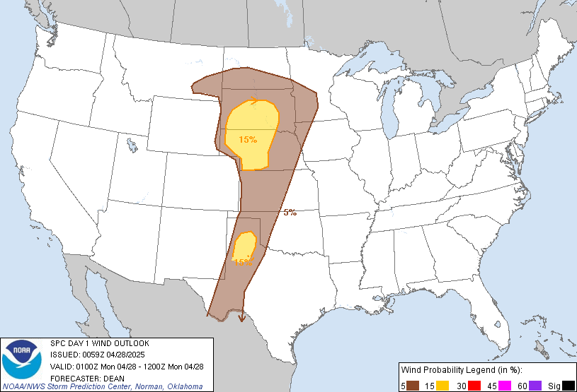
15 %
148,223
1,400,765
Lubbock, TX...Amarillo, TX...Rapid City, SD...Bismarck, ND...North Platte, NE...
5 %
314,238
8,949,290
Minneapolis, MN...St. Paul, MN...Lincoln, NE...Sioux Falls, SD...Billings, MT...
   SPC AC 280059

   Day 1 Convective Outlook
   NWS Storm Prediction Center Norman OK
   0759 PM CDT Sun Apr 27 2025

   Valid 280100Z - 281200Z

   ...THERE IS A SLIGHT RISK OF SEVERE THUNDERSTORMS FOR PARTS OF THE
   NORTHERN GREAT PLAINS INTO NE...AND PARTS OF THE SOUTHERN HIGH
   PLAINS...

   ...SUMMARY...
   Isolated to scattered severe thunderstorms are possible this evening
   into early morning Monday across parts of the Great Plains. Large to
   very large hail, severe gusts, and a few tornadoes are all possible.

   ...Northern Great Plains into NE...MN...northern IA...
   Supercell development is underway this evening across parts of
   western NE, with other strong to potentially severe storms expected
   to increase in coverage from southeast MT into western SD. The
   environment across parts of western NE and vicinity has become
   favorable for tornadoes this evening, including strong-tornado
   potential. See MCD 580 for more information.

   Some threat for hail, severe gusts, and possibly a tornado will also
   persist through the evening from southeast MT into western SD. Late
   tonight, some clustering/upscale growth is expected, with at least
   an isolated threat of hail and strong/damaging gusts eventually
   spreading into parts of MN and northern IA before the end of the
   period.

   ...Central/southern High Plains...
   Despite a volatile environment (as noted in the 00Z AMA sounding),
   storms have struggled to initiate near the dryline from western KS
   into the TX Panhandle. There remains a narrow window of opportunity
   for storm initiation near the dryline through dusk, though
   confidence is not high due to generally nebulous large-scale ascent.
   A Slight Risk has been maintained for the remaining conditional
   threat this evening across the southern High Plains.

   Farther south, a cluster of initially high-based convection earlier
   intensified near/east of Lubbock. If convection in this area can
   become surface-based, then a couple of supercells could evolve with
   all severe hazards possible. However, recent trends suggest this
   activity may continue to weaken with time.

   ...Central MS vicinity...
   A couple stronger storms persist this evening across central MS,
   within a moderately unstable and modestly sheared environment. A
   general weakening trend is expected to continue with time, though
   some localized threat for hail or damaging gusts may continue for
   part of the evening.

   ..Dean.. 04/28/2025

   CLICK TO GET WUUS01 PTSDY1 PRODUCT

   NOTE: THE NEXT DAY 1 OUTLOOK IS SCHEDULED BY 0600Z