Chicago, IL...Indianapolis, IN...Oklahoma City, OK...Tulsa, OK...St. Louis, MO...
MARGINAL
178,612
26,517,748
Dallas, TX...Detroit, MI...Fort Worth, TX...Milwaukee, WI...Kansas City, MO...
Probabilistic Tornado Graphic
Probability of a tornado within 25 miles of a point. Hatched Area: 10% or greater probability of EF2 - EF5 tornadoes within 25 miles of a point.
Day 1 Tornado Risk
Area (sq. mi.)
Area Pop.
Some Larger Population Centers in Risk Area
5 %
23,801
1,793,588
Tulsa, OK...Norman, OK...Wichita Falls, TX...Lawton, OK...Broken Arrow, OK...
2 %
173,243
26,773,542
Chicago, IL...Indianapolis, IN...Oklahoma City, OK...St. Louis, MO...Fort Wayne, IN...
Probabilistic Damaging Wind Graphic
Probability of damaging thunderstorm winds or wind gusts of 50 knots or higher within 25 miles of a point. Hatched Area: 10% of greater probability of wind gusts 65 knots or greater within 25 miles of a point.
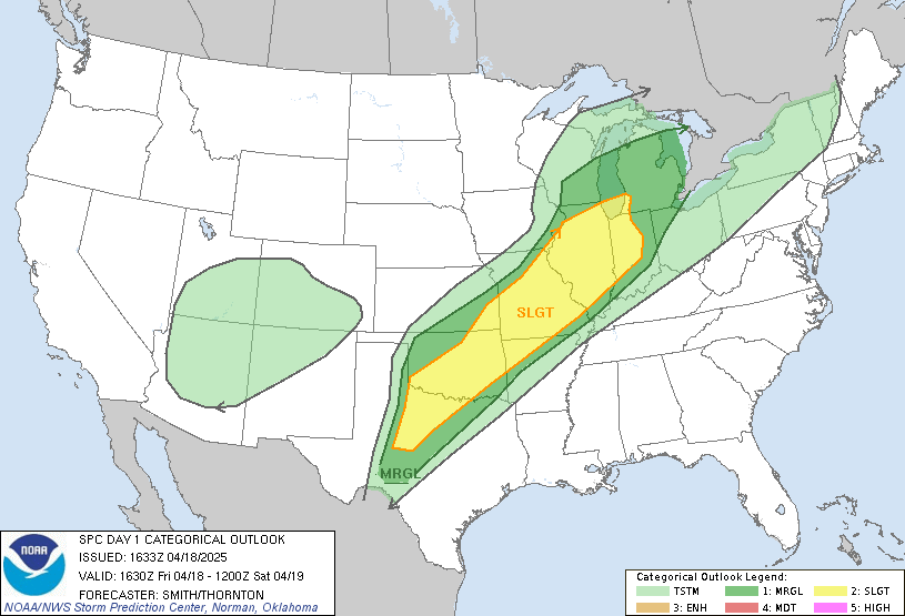
   SPC AC 181633

   Day 1 Convective Outlook
   NWS Storm Prediction Center Norman OK
   1133 AM CDT Fri Apr 18 2025

   Valid 181630Z - 191200Z

   ...THERE IS A SLIGHT RISK OF SEVERE THUNDERSTORMS FROM PARTS OF THE
   SOUTHERN PLAINS INTO THE MID MISSISSIPPI VALLEY AND SOUTHWESTERN
   GREAT LAKES...

   ...SUMMARY...
   Scattered severe thunderstorms are possible from parts of the
   southern Plains northeastward through the mid Mississippi Valley and
   southwestern Great Lakes, mainly from late afternoon into early
   Saturday morning.  Large to very large hail and severe wind gusts
   should be the main hazards, especially across the southern Plains
   where storms will be more concentrated.  A few tornadoes also appear
   possible.

   ...Southern Plains to the Ozarks...
   Strong southwesterly mid to high-level flow will extend from the
   southern High Plains northeastward into the Great Lakes, downstream
   of a mid- to upper-level low over the Four Corners states.  A cold
   front was analyzed from the Low Rolling Plains northeastward through
   central OK late this morning.  This portion of the front will
   continue southeastward into the I-44 corridor but decelerate towards
   late afternoon.  A dryline extends southward from the front over the
   TX Big Country.

   Despite widespread mid/high-level cloudiness, filtered heating of a
   moist/destabilizing airmass will likely result in a weakened cap by
   late afternoon.  Initial supercell development should pose a threat
   for large to very large hail, potentially up to 2-3 inches in
   diameter.  Model forecast hodographs and ample PW suggest a strong
   tendency towards upscale growth into an HP supercell and linear
   segment this evening from south-central OK northeastward towards the
   western part of the Ozark Plateau.  Coincident with this expected
   convective mode evolution, an increase in the severe/damaging wind
   threat is anticipated.  The threat for a few tornadoes remains
   apparent, especially across parts of OK along/south of the front, as
   favorable low-level shear will be present this evening where
   surface-based supercells and mesovortex potential may still exist.

   ...Lower MI to Mid Mississippi Valley...
   In wake of weakened thunderstorm activity across Lower MI, a warm
   sector will attempt to spread northward and destabilize
   across parts of the mid MS Valley and southern/central Great Lakes
   this afternoon.  An upper trough will only slowly encroach on the
   Upper Midwest through late tonight.  As a result, southwesterly flow
   aloft will be maintained and limited southeastward progression of a
   cold front is forecast.

   Model guidance continues to indicate surface-based thunderstorm
   development will be inhibited until peak heating, when frontal
   forcing and gradual erosion of the cap leads to isolated storms
   developing from MO northeastward towards the southwest Great Lakes.
   Uncertainty remains regarding timing, overall thunderstorm coverage,
   and the exact evolution of this activity.  Nonetheless, strong shear
   through a deep layer and adequate buoyancy (due in part to steep
   mid-level lapse rates), will support organized thunderstorms.  The
   stronger thunderstorms will probably pose a risk for severe hail and
   damaging winds.  This severe threat may persist for much of the
   evening, and perhaps continuing into the early overnight hours.

   ..Smith/Thornton.. 04/18/2025

   CLICK TO GET WUUS01 PTSDY1 PRODUCT

   NOTE: THE NEXT DAY 1 OUTLOOK IS SCHEDULED BY 2000Z