Probability of damaging thunderstorm winds or wind gusts of 50 knots or higher within 25 miles of a point. Hatched Area: 10% of greater probability of wind gusts 65 knots or greater within 25 miles of a point.
Day 1 Wind Risk
Area (sq. mi.)
Area Pop.
Some Larger Population Centers in Risk Area
15 %
170,850
10,766,003
Oklahoma City, OK...Kansas City, MO...Tulsa, OK...Wichita, KS...Lincoln, NE...
SPC AC 010538
Day 1 Convective Outlook
NWS Storm Prediction Center Norman OK
1238 AM CDT Tue Apr 01 2025
Valid 011200Z - 021200Z
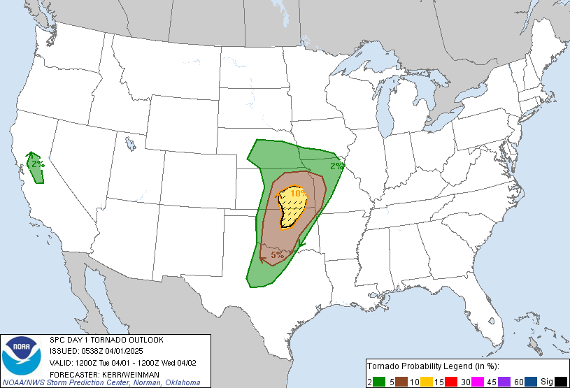
...THERE IS AN ENHANCED RISK OF SEVERE THUNDERSTORMS LATE THIS
EVENING ACROSS PARTS OF NORTH CENTRAL OKLAHOMA INTO SOUTH CENTRAL
KANSAS...
...SUMMARY...
Rapid, intense thunderstorm development is possible this evening
across parts of the central and southern Great Plains. A few
supercells posing a risk for large hail and a couple of strong
tornadoes are possible, particularly across parts of north central
Oklahoma into south central Kansas.
...Discussion...
Amplification of mid/upper flow across the southern mid-latitudes of
the eastern Pacific into western North America appears underway,
with a seasonably strong cyclonic jet now digging inland of the
central/southern California coast. An initially significant
mid-level low within the large-scale troughing to the north of this
feature appears to be in the process of devolving into at least a
couple of significant short wave perturbations as it progresses
inland of the northern Pacific coast.
Models indicate that the lead perturbation will progress across the
Rockies into the Great Plains today through tonight, and contribute
to significant lower/mid-tropospheric cyclogenesis over the north
central Great Plains through middle Missouri Valley by 12Z
Wednesday. A notable trailing perturbation is forecast to dig
inland of the Pacific coast, near and west of the Sierra Nevada.
Given the forecast synoptic pattern evolution, and intensifying
lower/mid tropospheric wind fields (including 50-70+ kt southerly
around 850 mb and 90-100+ kt southwesterly) across the south central
Great Plains into lower Missouri Valley late this evening through
early Wednesday, the environment would seem at least conditionally
supportive of an outbreak of severe thunderstorms. However,
low-level moisture return, in the wake of a still ongoing intrusion
of cool/dry air to the east of the Rockies, remains a source of
uncertainty, and a potentially limiting factor, concerning the risk
for severe thunderstorms today through tonight.
...Great Plains into portions of the Upper Midwest...
An initial narrow plume of low-level moisture return appears
underway up the Rio Grande Valley toward the Texas South Plains.
However, models continue to indicate that boundary-layer moistening,
characterized by lower/mid 60s surface dew points, may not begin
advecting to the north of the Red River until late afternoon. Even
so, there appears potential for this moisture to rapidly advect
northward, within deepening surface troughing, across parts of
western and central Oklahoma into central Kansas through late
evening.
In the presence of steep lapse rates, it appears that there may be
sufficient destabilization to support the initiation of widely
scattered thunderstorm development near the sharpening dryline, from
parts of west central Kansas into the Texas Edwards Plateau vicinity
by late afternoon. Strongest storms probably will be focused across
parts of southwestern Oklahoma into portions of the Texas South
Plains, where the environment may become conducive to the evolution
of supercells, though substantial mid-level inhibition may tend to
limit eastward propagation away from the dryline.
The most significant convective development still seems most
probable during the mid to late evening, in association with the
better low-level moisture return and destabilization, which is
forecast to coincide with the substantive intensification of the
wind fields in the 850-500 mb layer across the Texas/Oklahoma
Panhandle vicinity through southern Kansas/northern Oklahoma. This
may focus near/east-northeast of a developing triple point low,
generally forecast to track by a number of models across
northwestern Oklahoma through south central Kansas during the
02/03-06Z time frame.
Although the extent of upscale convective growth across this region
remains unclear, the environment appears conducive at least to the
evolution of several discrete supercells. These may be accompanied
by large hail initially, and increasing tornadic potential in the
presence of enlarging low-level hodographs and a moistening boundary
layer across and northeast of the I-35 corridor.
It is possible that elevated moisture return and destabilization
could be sufficient to support a risk for thunderstorms capable of
producing severe hail as far northeast as portions of the Upper
Midwest by late tonight.
...Interior Valley of central California...
Beneath cold air and an associated cyclonic vorticity center
forecast to overspread the region late this afternoon, it appears
that the environment could become conducive to an isolated strong
storm or two, which gust pose a risk for small hail, gusty winds and
perhaps a brief tornado or two.
..Kerr/Weinman.. 04/01/2025
CLICK TO GET WUUS01 PTSDY1 PRODUCT
NOTE: THE NEXT DAY 1 OUTLOOK IS SCHEDULED BY 1300Z