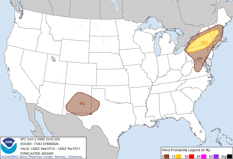
Probability of damaging thunderstorm winds or wind gusts of 50 knots or higher within 25 miles of a point. Hatched Area: 10% of greater probability of wind gusts 65 knots or greater within 25 miles of a point.
Probability of hail 1" or larger within 25 miles of a point. Hatched Area: 10% or greater probability of hail 2" or larger within 25 miles of a point.
Day 2 Hail Risk
Area (sq. mi.)
Area Pop.
Some Larger Population Centers in Risk Area
No Risk Areas Forecast
SPC AC 091724
Day 2 Convective Outlook
NWS Storm Prediction Center Norman OK
1224 PM CDT Tue Jul 09 2024
Valid 101200Z - 111200Z
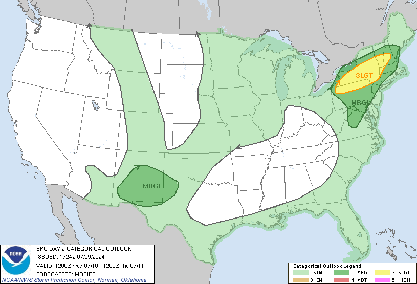
...THERE IS A SLIGHT RISK OF SEVERE THUNDERSTORMS FROM NORTHERN PA
AND MUCH OF CENTRAL AND SOUTHERN NY INTO SOUTHERN NH/VT AND WESTERN
MA....
...SUMMARY...
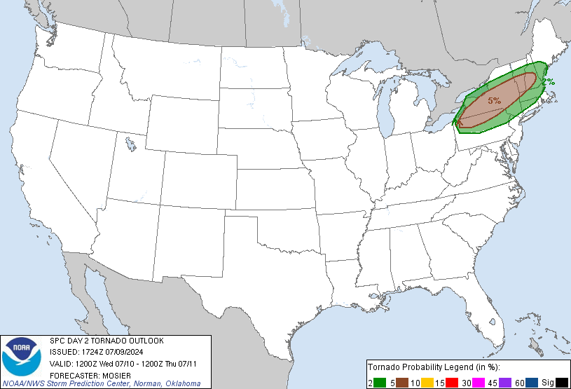
Damaging gusts and a few tornadoes are possible mainly from northern
Pennsylvania and much of central and southern New York into southern
New Hampshire/Vermont and western Massachusetts.
...Synopsis...
Upper troughing is expected to persist across the central and
eastern CONUS on Wednesday, supported by a pair of shortwave troughs
moving through the cyclonic flow aloft. Most prominent of these
shortwaves is associated with the remnants of TC Beryl and is
forecast to move quickly northeastward from its early period
position over the Middle OH Valley and Lower MI through the Lower
Great Lakes region and eastern Ontario. An associated surface low is
expected to progress northeastward just ahead of its parent
shortwave trough, moving from central IN/OH into the St. Lawrence
Valley while occluding. Cold front attendant to this system will
move eastward across the OH Valley and into the Mid-Atlantic.
Secondary surface cyclogenesis is possible Wednesday afternoon at
the triple point (which will likely be in the southwestern NY/Finger
Lakes vicinity), with the resulting low tracking northeastward into
northern NY.
Farther west, upper ridging centered over southern NV is expected to
build throughout the day, covering much of the western CONUS by
early Thursday morning. Modest northwesterly flow aloft is
anticipated between these two features over the High Plains, with
associated lee surface troughing.
...Northern Mid-Atlantic into Upper OH Valley and Northeast...
A occluded front will likely extend from the primary surface low
near the northern/central IN/OH border east-northeastward to the
triple point in the northeast OH/northwest PA vicinity early
Wednesday morning, with a warm front continuing eastward from the
triple point across southwest/south-central NY into MA. The
associated warm sector is expected to be characterized by dewpoints
in the upper 60s to low 70s, which are forecast to advect northward
as the surface low pushes east and the warm front lifts north.
Strong heating is anticipated within this warm sector as well, with
afternoon temperatures in the upper 80s and low 90s. These
thermodynamic conditions will support moderate to strong buoyancy
throughout the warm sector, with MLCAPE around 2000 J/kg.
Thunderstorm development is anticipated along the cold front, with
some pre-frontal development within areas of low-level confluence
possible as well. Deep-layer vertical shear across the warm sector
will be moderate (i.e. around 30-40 kt from 0-6 km bulk shear),
supporting the potential for organized storm structures and a few
supercells. Warm temperatures aloft will likely mitigate the hail
threat, but strong heating and resulting steep low-level lapse rates
will support damaging gusts. Additionally, some backing of the
surface winds (particularly near the warm front), could also result
in enough low-level veering with height to result in some tornado
potential. Greatest severe coverage is anticipated from southwest
NY/northwest PA northeastward across much of central and southern NY
into southern NH/VT and western MA.
...Portions of NM and west TX...
Afternoon and evening thunderstorms development is possible across
the region, beginning over the higher terrain, as the airmass
destabilizes amid strong heating and a low-amplitude shortwave
trough rounds the eastern periphery of the upper ridge. Buoyancy
will be modest, but high cloud bases and steep low-level lapse rates
will still support the potential for strong outflow capable of
damaging wind gusts. A few small clusters could aggregate outflow
for a couple hours to locally enhance the convective wind potential.
The threat should wane quickly during the evening as the boundary
layer stabilizes.
..Mosier.. 07/09/2024
CLICK TO GET WUUS02 PTSDY2 PRODUCT
NOTE: THE NEXT DAY 2 OUTLOOK IS SCHEDULED BY 0600Z