Little Rock, AR...Lafayette, LA...Tyler, TX...College Station, TX...Bryan, TX...
Probabilistic Damaging Wind Graphic
Probability of damaging thunderstorm winds or wind gusts of 50 knots or higher within 25 miles of a point. Hatched Area: 10% of greater probability of wind gusts 65 knots or greater within 25 miles of a point.
Day 2 Wind Risk
Area (sq. mi.)
Area Pop.
Some Larger Population Centers in Risk Area
5 %
188,373
15,238,812
Houston, TX...Memphis, TN...Shreveport, LA...Little Rock, AR...Pasadena, TX...
Probabilistic Large Hail Graphic
Probability of hail 1" or larger within 25 miles of a point. Hatched Area: 10% or greater probability of hail 2" or larger within 25 miles of a point.
Day 2 Hail Risk
Area (sq. mi.)
Area Pop.
Some Larger Population Centers in Risk Area
5 %
22,308
38,428
No Major Population Center in Risk Area
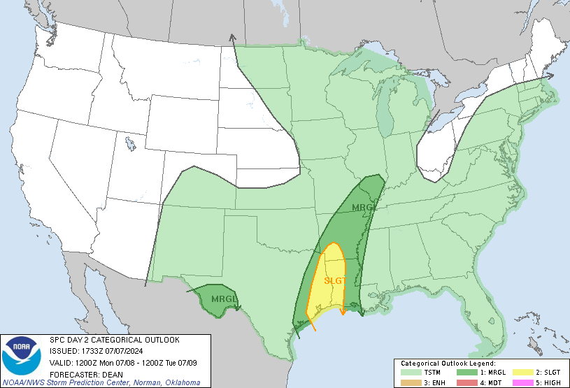
SPC AC 071733
Day 2 Convective Outlook
NWS Storm Prediction Center Norman OK
1233 PM CDT Sun Jul 07 2024
Valid 081200Z - 091200Z
...THERE IS A SLIGHT RISK OF SEVERE THUNDERSTORMS FOR PARTS OF EAST
TX...WESTERN LA...SOUTHWEST AR...
...SUMMARY...
A few tornadoes are possible on Monday from east Texas into western
Louisiana and southwest Arkansas, in association with Tropical
Cyclone Beryl.
...Synopsis...
Tropical Cyclone Beryl is currently forecast to strengthen into a
hurricane Sunday evening, and make landfall somewhere along the
middle TX Coast early Monday morning, shortly before the start of
the D2/Monday forecast period. Beryl is forecast to take on more of
a north-northeasterly motion during the day on Monday across east
TX, as it begins to become absorbed within a larger-scale
mid/upper-level trough moving across parts of the Great Lakes, Upper
Midwest, and Great Plains. A weak cold front will accompany this
trough across parts of the mid/upper MS Valley and Midwest/Great
Lakes. Farther southwest, an outflow-reinforced cold front will move
through parts of the southern High Plains into southern NM and far
west TX.
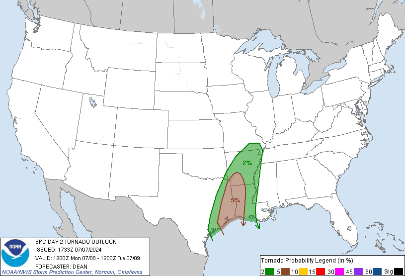
...LA/east TX into AR and southern MO/IL...
At least a few tornadoes will be possible from east TX into western
LA and southwest AR on Monday, in association with Tropical Cyclone
Beryl. Some expansion to the 5% tornado probabilities has been made
based on the latest guidance and NHC forecasts. A corridor of
greater tornado probabilities may eventually be needed, depending on
trends regarding the track, intensity, and size of Beryl.
Increasing low/midlevel flow along the eastern flank of Beryl will
spread across an already very moist environment across parts of east
TX and western LA through the day, with tropical moisture eventually
spreading northward into parts of AR, southern MO, and the mid-MS
Valley by afternoon/evening. While heating will be limited closer to
the immediate track, some modest destabilization will be possible to
the east/northeast of the center through the day. Strengthening
low-level shear/SRH (with 0-1 km SRH increasing above 200 m2/s2)
will support potential for a few tornadoes with at least transient
supercells, especially within the northeast quadrant of Beryl during
the day into the early evening. Some tornado threat could spread as
far north as the Ozarks region Monday night as Beryl continues
northeastward.
Additionally, well in advance of Beryl, a few strong storms could
develop from northern AR into southeast MO and southern IL during
the afternoon, within a moist and moderately buoyant environment.
Midlevel southwesterly flow will be sufficiently strong to support
modest storm organization, with a threat of locally damaging gusts.
...Parts of Far West into southwest TX...
Widely scattered thunderstorms are expected to develop Monday
afternoon across parts of the TX Trans-Pecos vicinity. Relatively
moist low-level easterly flow will support both favorable low-level
moisture and somewhat elongated hodographs across the region.
Moderate buoyancy and sufficient deep-layer shear will support a few
stronger cells/clusters, including the potential for a supercell or
two with a threat of isolated hail and severe gusts.
...Parts of the upper Midwest/Great Lakes...
Isolated to widely scattered thunderstorms will be possible across a
broad region of the upper Midwest and Great Lakes, in association
with the mid/upper-level trough gradually moving eastward across the
region. Modest buoyancy and modest deep-layer shear could support a
few stronger storms, and severe probabilities may eventually be
needed if a corridor of somewhat more focused potential becomes
apparent.
..Dean.. 07/07/2024
CLICK TO GET WUUS02 PTSDY2 PRODUCT
NOTE: THE NEXT DAY 2 OUTLOOK IS SCHEDULED BY 0600Z