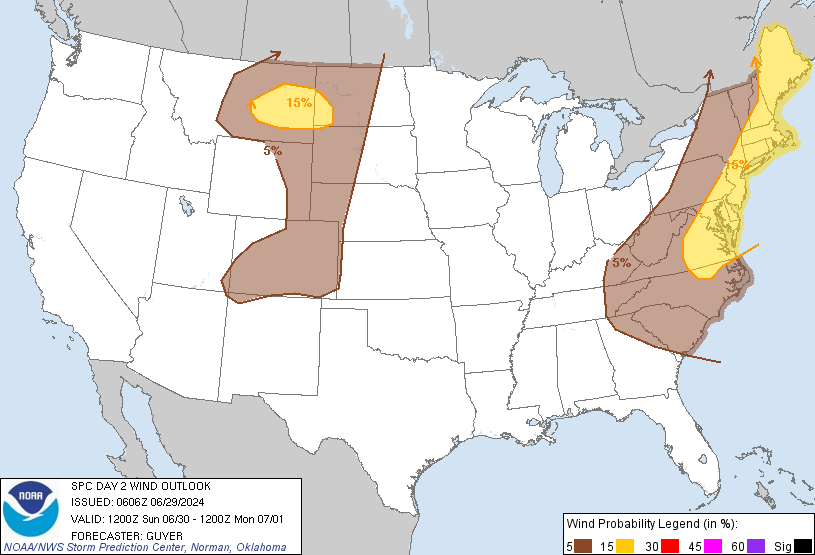
New York, NY...Philadelphia, PA...Baltimore, MD...Boston, MA...Washington, DC...
MARGINAL
518,241
35,905,893
Charlotte, NC...Denver, CO...Colorado Springs, CO...Raleigh, NC...Aurora, CO...
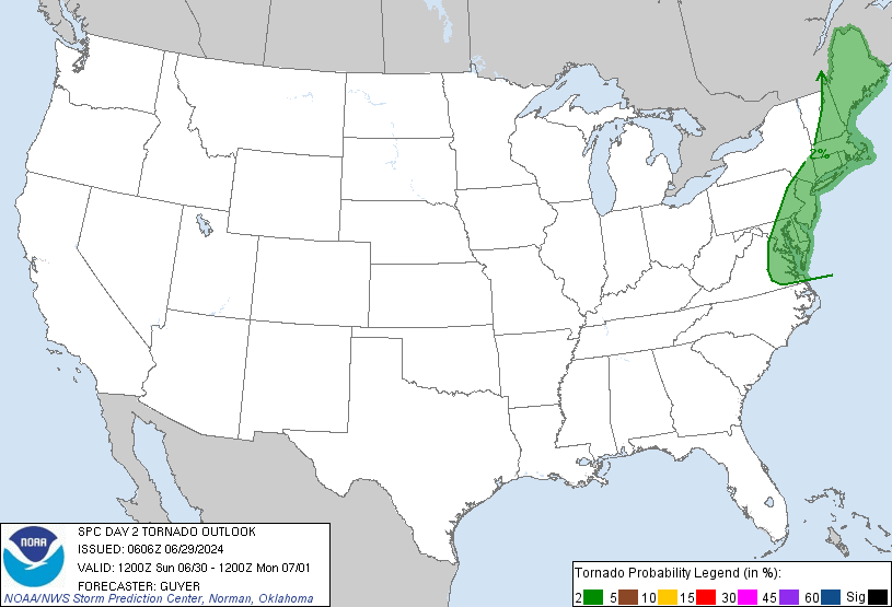
Probabilistic Tornado Graphic
Probability of a tornado within 25 miles of a point. Hatched Area: 10% or greater probability of EF2 - EF5 tornadoes within 25 miles of a point.
Day 2 Tornado Risk
Area (sq. mi.)
Area Pop.
Some Larger Population Centers in Risk Area
2 %
108,634
52,904,837
New York, NY...Philadelphia, PA...Baltimore, MD...Boston, MA...Washington, DC...
Probabilistic Damaging Wind Graphic
Probability of damaging thunderstorm winds or wind gusts of 50 knots or higher within 25 miles of a point. Hatched Area: 10% of greater probability of wind gusts 65 knots or greater within 25 miles of a point.
Day 2 Wind Risk
Area (sq. mi.)
Area Pop.
Some Larger Population Centers in Risk Area
15 %
162,446
55,826,223
New York, NY...Philadelphia, PA...Baltimore, MD...Boston, MA...Washington, DC...
5 %
499,276
35,575,879
Charlotte, NC...Denver, CO...Virginia Beach, VA...Colorado Springs, CO...Raleigh, NC...
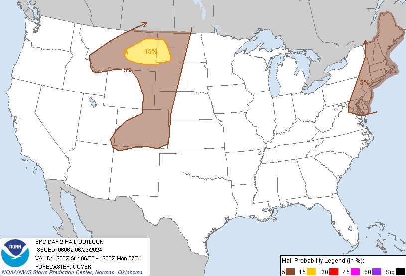
Probabilistic Large Hail Graphic
Probability of hail 1" or larger within 25 miles of a point. Hatched Area: 10% or greater probability of hail 2" or larger within 25 miles of a point.
Day 2 Hail Risk
Area (sq. mi.)
Area Pop.
Some Larger Population Centers in Risk Area
15 %
47,070
126,651
Dickinson, ND...Williston, ND...Miles City, MT...Glendive, MT...Sidney, MT...
5 %
404,496
59,848,920
New York, NY...Philadelphia, PA...Baltimore, MD...Boston, MA...Denver, CO...
SPC AC 290606
Day 2 Convective Outlook
NWS Storm Prediction Center Norman OK
0106 AM CDT Sat Jun 29 2024
Valid 301200Z - 011200Z
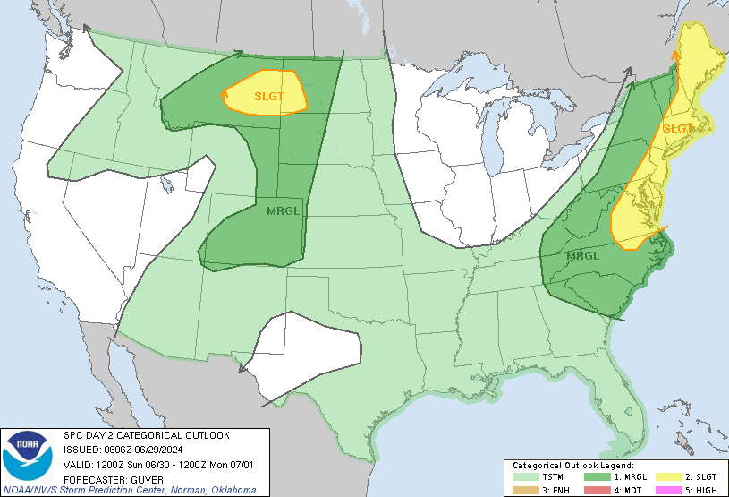
...THERE IS A SLIGHT RISK OF SEVERE THUNDERSTORMS ACROSS THE
NORTHEAST/MID-ATLANTIC STATES AND NORTHERN HIGH PLAINS...
...SUMMARY...
Scattered damaging winds will be possible across parts of the
Northeast and Mid-Atlantic States on Sunday. Hail and damaging winds
may also occur from eastern Montana into western North Dakota.
...Northeast/Mid-Atlantic States to Carolinas...
A positive-tilt upper-level trough will amplify over Ontario and
Quebec toward the Lower Great Lakes and Northeast Sunday and Sunday
night. A surface low will move from eastern Quebec to the Canadian
Maritimes, as a trailing cold front advances southeastward across
the Northeast/New England as well as the Appalachians, before
exiting the coastal Northeast/Mid-Atlantic by Sunday night. Some
potential warm-sector cloudiness and weak mid-level lapse rates may
somewhat limit or delay pre-frontal destabilization. However,
potentially moderate diurnal destabilization, in the presence of
moderate deep-layer shear, should exist for storms capable of
damaging winds and possibly some hail, mainly Sunday afternoon
through early evening.
Removed from the stronger cyclonic flow aloft, greater
destabilization is expected southward into the Carolinas within a
very moist environment. Modest-strength west/northwesterly winds
aloft could support some stronger cells/clusters capable of at least
isolated wind damage.
...Montana and western Dakotas...
A mid/upper-level trough will cross the northern Rockies on Sunday,
reaching and influencing the northern High Plains by Sunday night.
In response, a surface low is expected to deepen across southeast
Montana and northeast Wyoming, with increasing low-level moisture
north-northwestward into areas to east and north of the surface low,
including parts of Montana and the western Dakotas.
At least modest diurnal destabilization will be possible from
southwest into central Montana, with moderate buoyancy potentially
developing farther east into parts of eastern Montana and the
western Dakotas. Storm development will be possible across
western/central Montana during the afternoon. These storms may move
eastward with time, with other isolated development possible by
early evening into eastern Montana.
Increasing deep-layer shear will support organized convection, and a
few stronger clusters and/or supercells will be possible, with a
threat of hail and severe gusts. An MCS may develop Sunday night and
move into western/central North Dakota, aided by a nocturnally
strengthening low-level jet. The severity of any MCS will be more
uncertain with eastward extent, due to increasing low-level
stability. However, some threat for severe gusts could spread across
western and possibly central North Dakota.
Storm development/coverage is more uncertain farther south, but with
the environment expected to become conditionally favorable by late
afternoon into the evening, a strong/severe storm or two will also
be possible across eastern Wyoming into western South Dakota
including the Black Hills vicinity.
...Colorado Front Range into the central High Plains...
In the wake of a cold frontal passage, low-level moisture will
stream westward into the Front Range vicinity and adjacent central
High Plains, with the western extension of the boundary expected to
lift northward as a warm front through the day. Moderate
destabilization will be possible during the afternoon, with
potential for at least isolated storm development. Mid-level winds
will likely remain weak to modest, but sufficient veering with
height could support organized multicellular clusters and perhaps a
supercell or two, with a threat of hail and severe gusts.
...Southeast Arizona...
Some showers/thunderstorms, or least outflow/cloud debris, could
linger early in the day, but airmass recovery/destabilization is
expected into the afternoon. Mid-level temperatures will be warm,
but sufficient diurnally maximized instability could contribute to a
few strong storms. The region will be reevaluated in subsequent
outlooks for a potential inclusion of low wind-related severe
probabilities.
...South-central Great Plains to Tennessee Valley...
A cold front is forecast to move into parts of the south-central
Great Plains and Ozark vicinity Sunday morning, potentially
accompanied and augmented by ongoing convection. Moderate to locally
strong buoyancy may develop along/south the front during the
afternoon, in areas that are not influenced by early-day convection.
Mid-level flow will likely remain weak. Given the rather weakly
sheared environment and uncertainty regarding the favored frontal
corridor, severe probabilities will continue to be deferred.
..Guyer.. 06/29/2024
CLICK TO GET WUUS02 PTSDY2 PRODUCT
NOTE: THE NEXT DAY 2 OUTLOOK IS SCHEDULED BY 1730Z