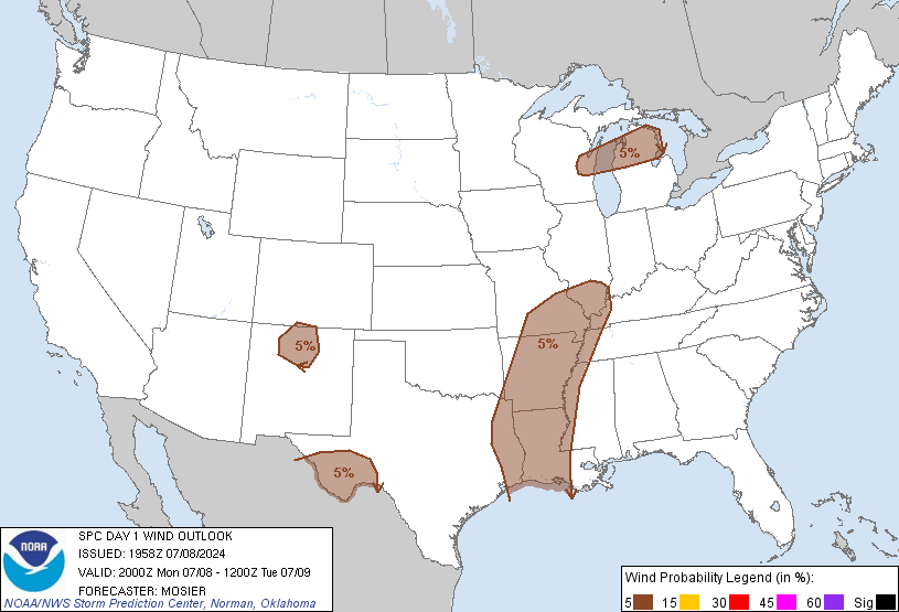
Probability of damaging thunderstorm winds or wind gusts of 50 knots or higher within 25 miles of a point. Hatched Area: 10% of greater probability of wind gusts 65 knots or greater within 25 miles of a point.
Day 1 Wind Risk
Area (sq. mi.)
Area Pop.
Some Larger Population Centers in Risk Area
5 %
219,646
11,499,468
Memphis, TN...Baton Rouge, LA...Shreveport, LA...Little Rock, AR...Lafayette, LA...
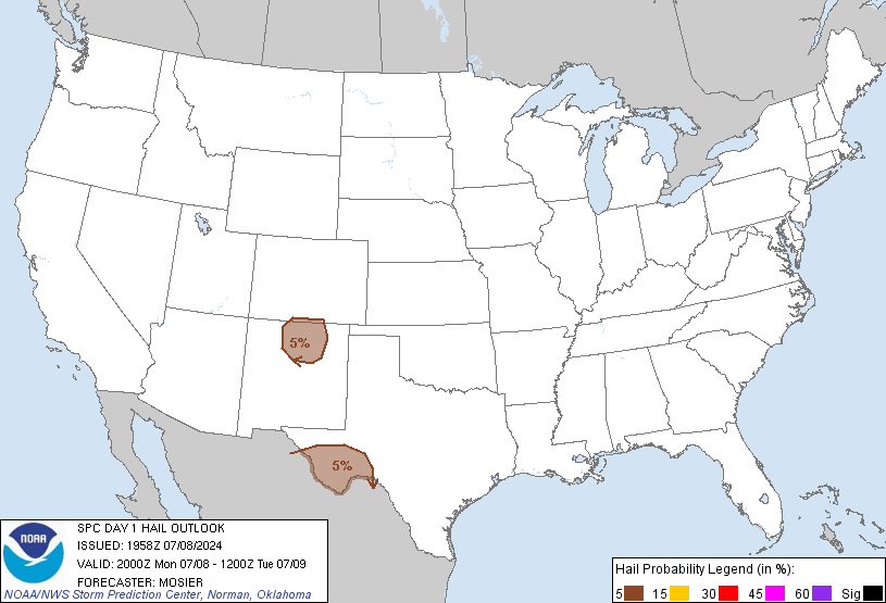
Probabilistic Large Hail Graphic
Probability of hail 1" or larger within 25 miles of a point. Hatched Area: 10% or greater probability of hail 2" or larger within 25 miles of a point.
Day 1 Hail Risk
Area (sq. mi.)
Area Pop.
Some Larger Population Centers in Risk Area
5 %
41,020
320,061
Santa Fe, NM...Las Vegas, NM...Los Alamos, NM...Espanola, NM...Taos, NM...
SPC AC 081958
Day 1 Convective Outlook
NWS Storm Prediction Center Norman OK
0258 PM CDT Mon Jul 08 2024
Valid 082000Z - 091200Z
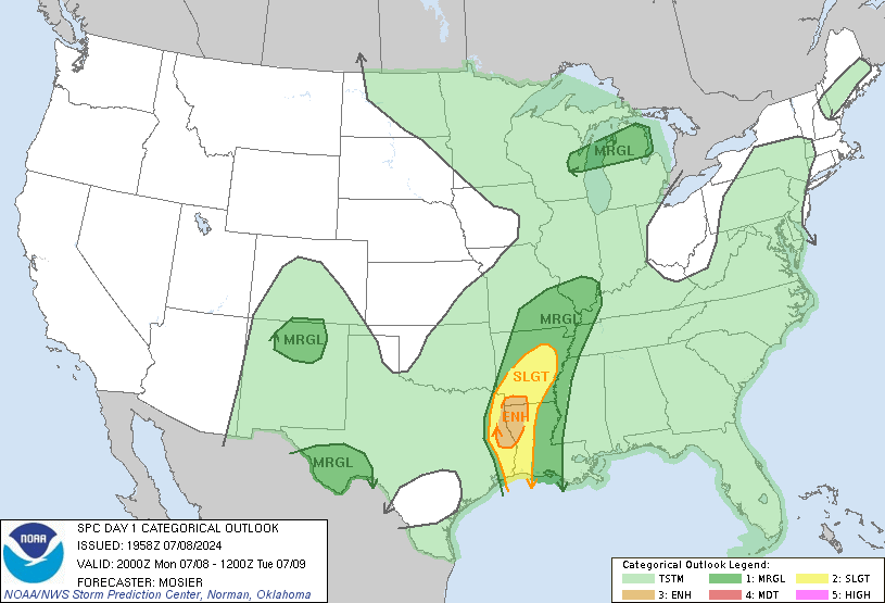
...THERE IS AN ENHANCED RISK OF SEVERE THUNDERSTORMS ACROSS EAST
TX...NORTHWEST LA...AND SOUTHWEST AR...
...SUMMARY...
Several tornadoes are possible today and tonight in association with
Tropical Cyclone Beryl, from eastern Texas into western/northern
Louisiana and southern/eastern Arkansas.
...20Z Update...
...East/Northeast TX into Northwest/Central LA and Southern/Eastern
AR...
Several low-topped supercells have developed with a convective band
arcing from Rusk and Gregg Counties in northeast TX to Natchitoches
and Winn Parishes in central LA. This intensification appears to be
associated with greater low-level convergence and increased buoyancy
(particularly in the 0-3 km layer) amid already strong low to
mid-level flow. Recently issued MCD #1560 discusses the short-term
trends within this area as well.
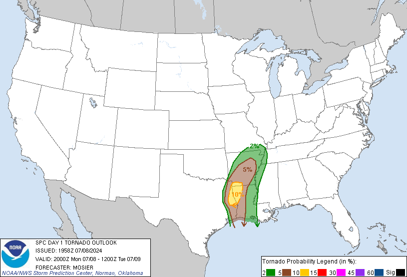
Beryl is forecast to continue northeastward, potentially taking this
area of greater storm production into southern/eastern AR. The 5%
tornado probabilities were expanded northeastward to account for
some increased tornado potential as this area of Beryl moves into
more of northeast AR later this evening and tonight.
...Elsewhere...
As mentioned in recently issued MCD #1559, isolated and marginally
severe hail and strong/severe wind gusts are possible as storms
develop and move southeastward across north-central NM. Isolated
severe thunderstorms are still anticipated across southwest TX this
afternoon and evening, with some large hail and damaging gusts
possible. Isolated thunderstorms capable of damaging gusts also
remain possible this afternoon and evening from northern WI into
northern Lower MI.
..Mosier.. 07/08/2024
.PREV DISCUSSION... /ISSUED 1130 AM CDT Mon Jul 08 2024/
...East Texas/ArkLaTex/Ozarks/Lower to Mid Mississippi Valley...
Tropical Storm Beryl will continue north-northeastward today across
southeast/east Texas and toward the ArkLaTex tonight, with its
eastern-peripheral low/mid-level wind field remaining strong through
tonight. Embedded circulations continue to occur within the modestly
broken convective bands, that will northward-transition and
potentially diurnally expand somewhat from east Texas into
western/northern Louisiana, and the ArkLaTex vicinity this evening.
Several tornadoes are possible especially through early evening, but
some tornado/wind damage risk will linger/transition northeastward
through late tonight across additional parts of Arkansas/Mid-South
and Mississippi Valley. For additional short-term details, see
Mesoscale Discussion 1558.
...Southwest Texas...
A cold front will continue to surge southward across the region,
with stronger heating and moderate destabilization occurring across
parts of the Transpecos and Big Bend vicinity in the presence of
upper 50s/lower 60s F surface dewpoints. Increasing low-level
convergence along the front and differential heating over higher
terrain should lead to increasing thunderstorm development this
afternoon, with some of these storms potentially posing large hail
and strong wind gust risks.
...Northern New Mexico/far Southern Colorado...
A considerable westward surge of moisture has occurred since
yesterday, with the 12z Albuquerque sounding featuring 0.80 inch
Precipitable Water. Terrain influences/differential heating over
interior New Mexico/southern Colorado will lead to increasing
thunderstorm development this afternoon in the presence of as much
as 500-1000 J/kg MLCAPE. Storm organization will likely be aided by
a moderately strong belt of north-northwesterly winds aloft.
Isolated instances of severe hail are expected this afternoon
through early evening, along with the possibility of severe-caliber
wind gusts.
...Northern Lower Michigan/Lake Michigan vicinity...
Gradual destabilization is expected this afternoon in the wake of
early day cloud cover and some outflow across the middle part of
Lower Michigan. This be within a moist air mass (mid/upper 60s F
surface dewpoints) ahead of an eastward-moving/weakening front, as a
shortwave trough otherwise moves eastward over Lake Superior and
northern Ontario. Modestly long/semi-straight hodographs with 30-35
kt effective shear could support some sustained storms/multicells,
with a couple instances of wind damage/sub-severe hail possible
through early evening.
CLICK TO GET WUUS01 PTSDY1 PRODUCT
NOTE: THE NEXT DAY 1 OUTLOOK IS SCHEDULED BY 0100Z