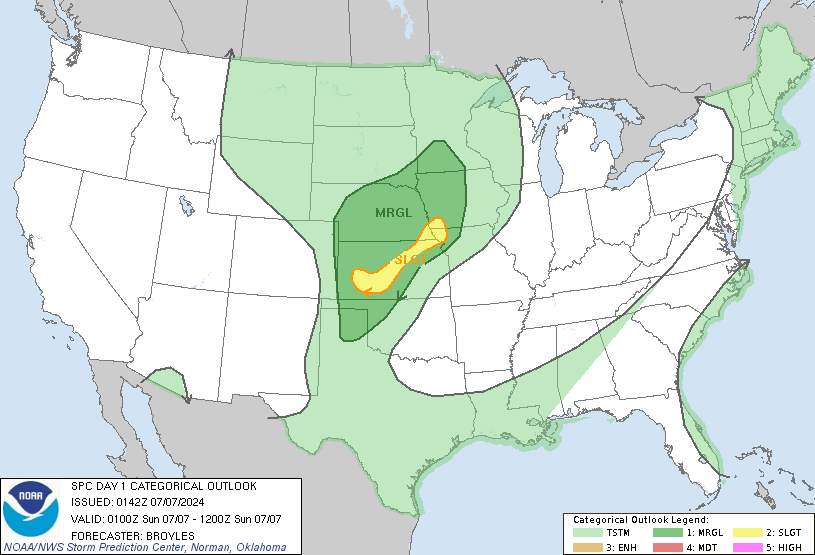
Salina, KS...Garden City, KS...Dodge City, KS...Great Bend, KS...Maryville, MO...
MARGINAL
178,981
5,085,969
Omaha, NE...Lincoln, NE...Des Moines, IA...Sioux Falls, SD...Topeka, KS...
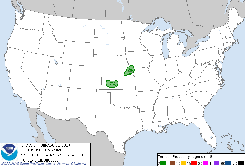
Probabilistic Tornado Graphic
Probability of a tornado within 25 miles of a point. Hatched Area: 10% or greater probability of EF2 - EF5 tornadoes within 25 miles of a point.
Day 1 Tornado Risk
Area (sq. mi.)
Area Pop.
Some Larger Population Centers in Risk Area
2 %
19,020
283,266
Garden City, KS...Dodge City, KS...Great Bend, KS...Maryville, MO...
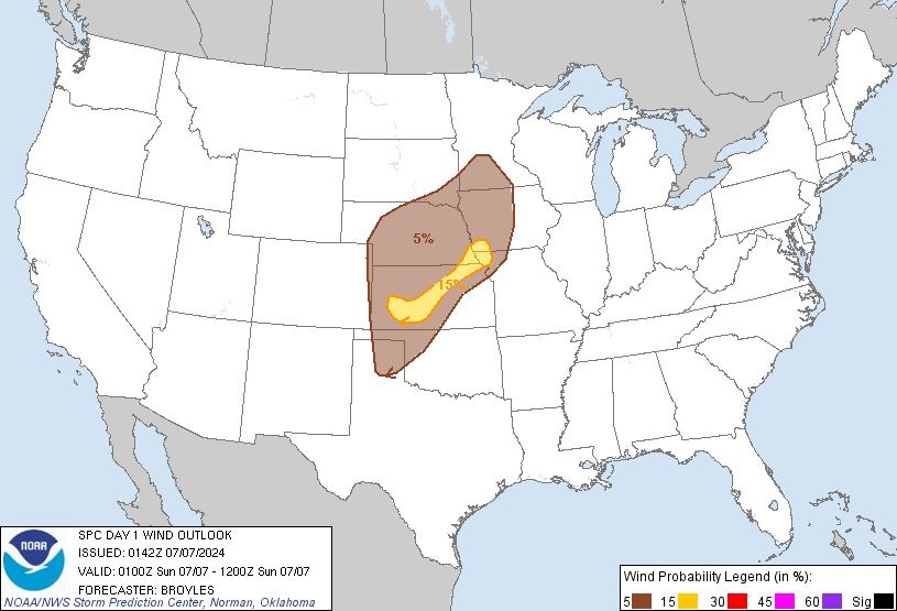
Probabilistic Damaging Wind Graphic
Probability of damaging thunderstorm winds or wind gusts of 50 knots or higher within 25 miles of a point. Hatched Area: 10% of greater probability of wind gusts 65 knots or greater within 25 miles of a point.
Day 1 Wind Risk
Area (sq. mi.)
Area Pop.
Some Larger Population Centers in Risk Area
15 %
25,150
403,325
Salina, KS...Garden City, KS...Dodge City, KS...Great Bend, KS...Maryville, MO...
5 %
179,039
5,101,247
Omaha, NE...Lincoln, NE...Des Moines, IA...Sioux Falls, SD...Topeka, KS...
Probabilistic Large Hail Graphic
Probability of hail 1" or larger within 25 miles of a point. Hatched Area: 10% or greater probability of hail 2" or larger within 25 miles of a point.
Day 1 Hail Risk
Area (sq. mi.)
Area Pop.
Some Larger Population Centers in Risk Area
15 %
24,964
399,799
Salina, KS...Garden City, KS...Dodge City, KS...Great Bend, KS...Maryville, MO...
5 %
179,434
5,173,196
Omaha, NE...Wichita, KS...Lincoln, NE...Des Moines, IA...Sioux Falls, SD...
   SPC AC 070142

   Day 1 Convective Outlook CORR 1
   NWS Storm Prediction Center Norman OK
   0842 PM CDT Sat Jul 06 2024

   Valid 070100Z - 071200Z

   ...THERE IS A SLIGHT RISK OF SEVERE THUNDERSTORMS ACROSS PARTS OF
   THE CENTRAL PLAINS...

   CORRECTED FOR FLIPPED THUNDER LINE

   ...SUMMARY...
   Scattered severe storms will continue this evening across parts of
   the central Plains. A few marginally severe storms will be possible
   further west into the southern and central High Plains, and
   northward into the mid Missouri Valley.

   ...Central Plains/Southern and Central High Plains/Mid Missouri
   Valley...
   The latest water vapor imagery shows an upper-level low over the
   eastern Dakotas, with a shortwave trough extending southward from
   the low into the central Plains. At the surface, a cold front is
   located from western Nebraska into southeastern South Dakota, along
   which a marginal severe threat will continue this evening. Further
   southeastward into the warm sector, a couple convective systems are
   ongoing along and to the east of the shortwave trough. An organized
   line segment is located in far southeast Nebraska, along the western
   edge of a corridor of moderate instability, where the RAP is
   analyzing MLCAPE in the 1000 to 1500 J/kg range. WSR-88D VWPs in
   this area have southeasterly winds at the surface, with winds
   gradually veering to westerly in the mid-levels. This wind profile
   will continue to be favorable for linear organization, and a
   wind-damage threat is expected to continue in the vicinity of far
   southeast Nebraska and far northwest Missouri this evening. Hail
   will also likely accompany the stronger cells embedded in this line.

   Further to the southwest into west-central Kansas, a severe
   convective cluster is also ongoing along and to the east of a
   north-to-south corridor of moderate instability. Near this area, the
   RAP is analyzing MLCAPE in the 1000 to 2000 J/kg range. This
   convection is located just to the north of the Dodge City WSR-88D
   VWP, which has 0-6 km shear near 40 knots. This shear environment
   should be enough to continue a threat for supercells this evening.
   Supercells will likely be capable of isolated large hail. A few
   severe wind gusts will also be possible. The ongoing convective
   systems in Kansas and Nebraska are expected to continue into the
   late evening, but the severe threat should become more isolated with
   time as instability gradually decreases across the central Plains.

   ..Broyles.. 07/07/2024

   CLICK TO GET WUUS01 PTSDY1 PRODUCT

   NOTE: THE NEXT DAY 1 OUTLOOK IS SCHEDULED BY 0600Z