Probability of damaging thunderstorm winds or wind gusts of 50 knots or higher within 25 miles of a point. Hatched Area: 10% of greater probability of wind gusts 65 knots or greater within 25 miles of a point.
Day 1 Wind Risk
Area (sq. mi.)
Area Pop.
Some Larger Population Centers in Risk Area
SIG SEVERE
89,036
7,085,054
Oklahoma City, OK...Kansas City, MO...Tulsa, OK...Wichita, KS...Overland Park, KS...
45 %
21,160
759,223
Joplin, MO...Bartlesville, OK...Emporia, KS...Pittsburg, KS...Junction City, KS...
30 %
49,267
4,629,341
Kansas City, MO...Tulsa, OK...Wichita, KS...Overland Park, KS...Springfield, MO...
15 %
135,335
8,710,574
Fort Worth, TX...Oklahoma City, OK...Arlington, TX...Lincoln, NE...Abilene, TX...
SPC AC 250558
Day 1 Convective Outlook
NWS Storm Prediction Center Norman OK
1258 AM CDT Sat May 25 2024
Valid 251200Z - 261200Z
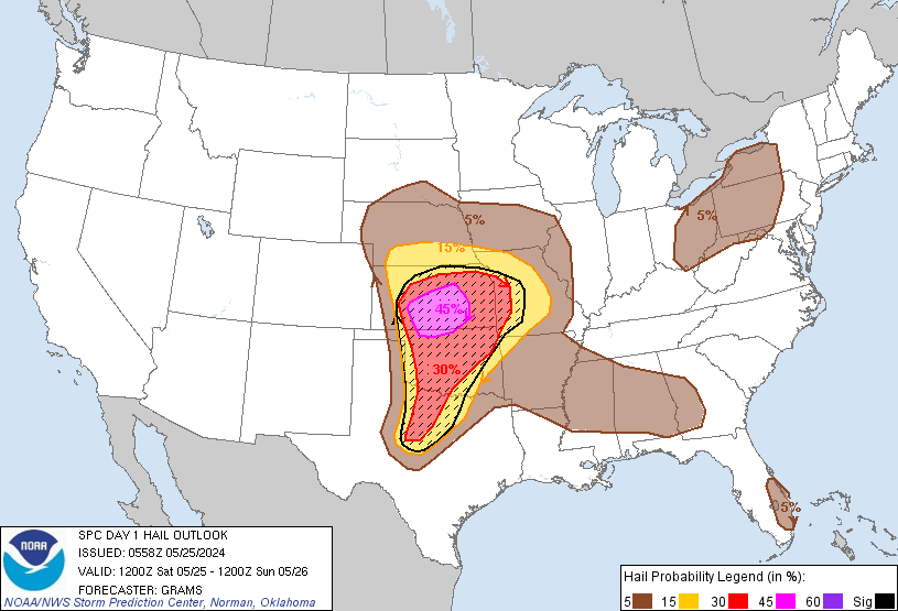
...THERE IS A MODERATE RISK OF SEVERE THUNDERSTORMS IN PARTS OF
KANSAS/OKLAHOMA AND FAR SOUTHWEST MISSOURI...
...SUMMARY...
An outbreak of severe thunderstorms is forecast from late afternoon
into tonight across parts of the central and southern Great Plains.
A few long-lived supercells capable of intense tornadoes may occur.
Giant hail and destructive wind gusts are also expected.
...Central and southern Great Plains...
Much uncertainty plagues this outlook cycle, with the level
4-Moderate risk left as-is. This evening's guidance has trended
slower and more confined with the boundary-layer moisture return,
with most CAMs also suggesting earlier afternoon initiation
occurring along the periphery of the richer moisture in west TX.
Level 5-High risk potential remains evident with the 00Z HRRR
indicating a possible tornado outbreak scenario with long-lived
strong to violent tornadoes.
Consensus of evening guidance suggests low-level moisture return
will be within a confined swath emanating north from the
south-central TX portion of the Rio Grande Valley into west TX. This
will occur downstream of a modestly amplified mid-level trough,
consisting of multiple embedded shortwave impulses, ejecting across
the West into the central and southern High Plains. Surface
temperatures west of the dryline will become hot, and most CAMs
indicate early to mid-afternoon thunderstorm development in the TX
Big Country/western north TX vicinity. It is probable that this will
become the southern extent of the overall severe threat with
slow-moving supercells persisting into the evening.
Across OK/KS, richer and deeper boundary-layer moisture ahead of the
dryline should be confined to western OK through late afternoon. A
more well-mixed boundary layer is expected farther north in
western/central KS, while the rich moisture should be shallow in
central OK before deepening later. Most guidance suggests high-based
thunderstorms will develop in the late afternoon across southwest NE
and northwest KS, where mid-level cooling will be greatest.
Very large hail and isolated severe wind gusts will be the primary
threats during the afternoon with relatively elongated/straight
hodographs supporting potential for left and right-splitting
supercells. A strengthening low-level jet will aid in the tornado
threat substantially increasing by early evening. The most volatile
environment for long-lived, intense tornadic supercells should exist
over the western half of OK. Primary uncertainty precluding an
upgrade is the degree of impact earlier afternoon storms to the
south may have on this setup with left-splits/outflows.
The northern periphery of the richer/deeper moisture surge and
robust low-level jet is eventually expected to reach at least into
southern KS during the evening. Supercells in this region will
strengthen as this occurs, and become capable of producing
long-lived, intense tornadoes after dusk. But with time tonight,
increasing large-scale ascent should support a supercell to bow echo
to MCS evolution towards the Ozark Plateau vicinity. This should
yield a swath of damaging winds, with embedded significant severe
gusts and tornadoes possible as it tracks eastward along the MLCAPE
gradient overnight.
...Eastern States...
Three areas of level 1-MRGL risk are forecast today with sporadic
severe hail and locally damaging winds possible.
Remnant morning convection and attendant MCVs may aid in isolated
severe across parts of the Deep South early, before
spreading/developing east towards parts of the coastal Atlantic
Southeast during the afternoon. Separately, a marginal supercell
wind profile will also exist along the southeast FL sea breeze.
Across the Lower Great Lakes to central/northern Appalachians,
initial mid-level ridging will evolve to a flatter, zonal flow
regime. The trailing surface front attendant to a nearly stationary,
occluded cyclone along the southeast MB/northwest ON border area
should aid in isolated to scattered thunderstorms this afternoon,
some of which should become strong.
..Grams/Moore.. 05/25/2024
CLICK TO GET WUUS01 PTSDY1 PRODUCT
NOTE: THE NEXT DAY 1 OUTLOOK IS SCHEDULED BY 1300Z