Omaha, NE...Lincoln, NE...Sioux City, IA...Council Bluffs, IA...Bellevue, NE...
SLIGHT
401,883
25,851,659
Dallas, TX...Fort Worth, TX...Oklahoma City, OK...Nashville, TN...Kansas City, MO...
MARGINAL
510,982
89,260,413
New York, NY...Philadelphia, PA...Memphis, TN...Baltimore, MD...Charlotte, NC...
Probabilistic Tornado Graphic
Probability of a tornado within 25 miles of a point. Hatched Area: 10% or greater probability of EF2 - EF5 tornadoes within 25 miles of a point.
Day 1 Tornado Risk
Area (sq. mi.)
Area Pop.
Some Larger Population Centers in Risk Area
5 %
114,753
3,174,211
Omaha, NE...Lincoln, NE...Wichita Falls, TX...Lawton, OK...Sioux City, IA...
2 %
281,499
18,037,623
Dallas, TX...Fort Worth, TX...Oklahoma City, OK...Arlington, TX...Wichita, KS...
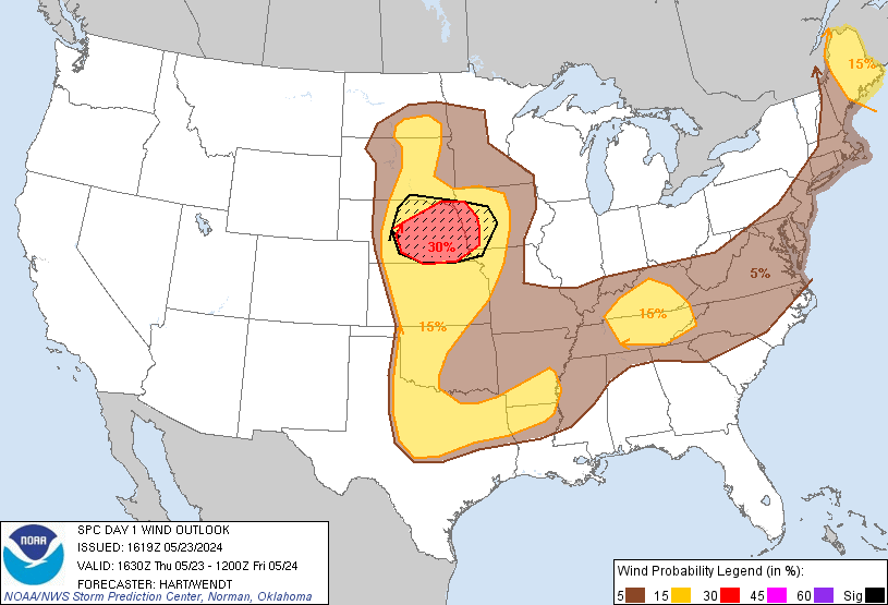
Probabilistic Damaging Wind Graphic
Probability of damaging thunderstorm winds or wind gusts of 50 knots or higher within 25 miles of a point. Hatched Area: 10% of greater probability of wind gusts 65 knots or greater within 25 miles of a point.
Day 1 Wind Risk
Area (sq. mi.)
Area Pop.
Some Larger Population Centers in Risk Area
SIG SEVERE
60,384
2,218,672
Omaha, NE...Lincoln, NE...Sioux City, IA...Council Bluffs, IA...Bellevue, NE...
30 %
42,796
1,988,825
Omaha, NE...Lincoln, NE...Sioux City, IA...Council Bluffs, IA...Bellevue, NE...
15 %
349,824
23,727,107
Dallas, TX...Fort Worth, TX...Oklahoma City, OK...Nashville, TN...Kansas City, MO...
5 %
536,234
91,159,878
New York, NY...Philadelphia, PA...Memphis, TN...Baltimore, MD...Charlotte, NC...
Probabilistic Large Hail Graphic
Probability of hail 1" or larger within 25 miles of a point. Hatched Area: 10% or greater probability of hail 2" or larger within 25 miles of a point.
Day 1 Hail Risk
Area (sq. mi.)
Area Pop.
Some Larger Population Centers in Risk Area
SIG SEVERE
207,762
12,333,172
Dallas, TX...Fort Worth, TX...Oklahoma City, OK...Arlington, TX...Wichita, KS...
15 %
326,795
17,639,290
Dallas, TX...Fort Worth, TX...Oklahoma City, OK...Omaha, NE...Arlington, TX...
5 %
570,044
93,137,427
New York, NY...Philadelphia, PA...Memphis, TN...Baltimore, MD...Charlotte, NC...
   SPC AC 231619

   Day 1 Convective Outlook
   NWS Storm Prediction Center Norman OK
   1119 AM CDT Thu May 23 2024

   Valid 231630Z - 241200Z

   ...THERE IS AN ENHANCED RISK OF SEVERE THUNDERSTORMS THIS EVENING
   AND TONIGHT OVER PORTIONS OF NEBRASKA AND WESTERN IOWA...

   ...THERE IS A SLIGHT RISK OF SEVERE THUNDERSTORMS OVER PARTS OF THE
   PLAINS STATES...MAINE...AND THE TENNESSEE VALLEY...

   ...SUMMARY...
   Severe thunderstorms are possible today across parts of the Plains,
   Tennessee Valley, and Maine.  A concentration of severe winds --
   some 75 mph or more -- is expected across a portion of the central
   Plains this evening into tonight.

   ...Northern Plains...
   Visible satellite imagery shows strong daytime heating occurring
   across much of the central and northern Plains, with southerly
   low-level winds drawing moisture northward into the region.
   Dewpoints will only be in the 50s across ND/SD/NE/KS this afternoon
   as initial thunderstorms develop ahead of a potent upper trough and
   associated mid-level speed max.  These initial storms will be
   relatively high-based supercells capable of very large hail and
   damaging winds.  A tornado or two is also possible.  As the evening
   progresses,  model guidance is in strong agreement that storms will
   grow upscale into a fast-moving QLCS with an enhanced risk of
   damaging winds across much of central/eastern NE into western IA.

   ...Southern Plains...
   Multiple rounds of thunderstorms over TX during the past 24 hours
   have resulted in a complex surface pattern, with pockets of
   low-clouds and more stable air.  This tends to limit the confidence
   in where robust thunderstorms will form later today.  Two areas of
   concern are 1) western OK/northwest TX along the dryline, and 2)
   central/north TX in vicinity of remnant outflow boundaries.  In both
   areas, very large CAPE values and favorable vertical profiles will
   favor supercell storms capable of very large hail, damaging winds,
   and a tornado or two.  Considered adding an small ENH to western OK,
   but there wasn't sufficient confidence on where to place it.

   ...Maine...
   Thunderstorms are beginning to develop along a cold front extending
   from NH into Quebec.  Strong heating is occurring ahead of the front
   across ME, where a few severe storms are possible later today.  See
   MCD #909 for further details.

   ...TN Valley...
   Strong heating is ongoing across parts of middle/east TN and central
   KY.  Dewpoints near 70F will likely lead to a cluster of
   thunderstorms this afternoon.  Forecast soundings show sufficient
   westerly flow aloft and steep low-level lapse rates to pose a risk
   of damaging wind gusts and hail in the strongest cells.

   ..Hart/Wendt.. 05/23/2024

   CLICK TO GET WUUS01 PTSDY1 PRODUCT

   NOTE: THE NEXT DAY 1 OUTLOOK IS SCHEDULED BY 2000Z