Probability of damaging thunderstorm winds or wind gusts of 50 knots or higher within 25 miles of a point. Hatched Area: 10% of greater probability of wind gusts 65 knots or greater within 25 miles of a point.
Probabilistic Large Hail Graphic
Probability of hail 1" or larger within 25 miles of a point. Hatched Area: 10% or greater probability of hail 2" or larger within 25 miles of a point.
Day 1 Hail Risk
Area (sq. mi.)
Area Pop.
Some Larger Population Centers in Risk Area
SIG SEVERE
209,992
18,967,517
Dallas, TX...Fort Worth, TX...Kansas City, MO...Omaha, NE...Tulsa, OK...
45 %
21,824
1,090,659
Des Moines, IA...St. Joseph, MO...Ames, IA...West Des Moines, IA...Ankeny, IA...
30 %
79,604
6,284,585
Kansas City, MO...Omaha, NE...Lincoln, NE...Overland Park, KS...Kansas City, KS...
Sioux Falls, SD...Waco, TX...South Bend, IN...Killeen, TX...Norman, OK...
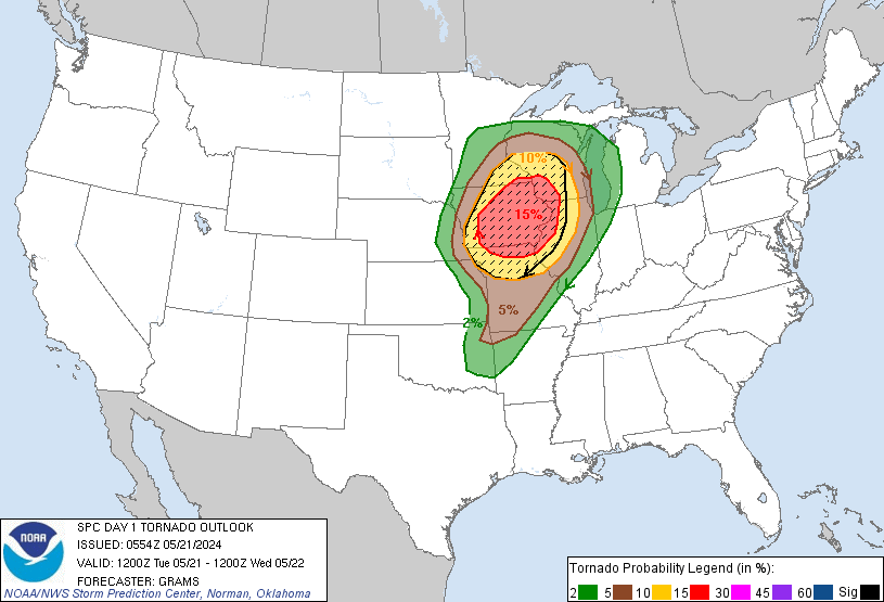
   SPC AC 210554

   Day 1 Convective Outlook
   NWS Storm Prediction Center Norman OK
   1254 AM CDT Tue May 21 2024

   Valid 211200Z - 221200Z

   ...THERE IS A MODERATE RISK OF SEVERE THUNDERSTORMS IN PARTS OF
   IOWA...NORTHERN MISSOURI...NORTHWEST ILLINOIS...SOUTHWEST
   WISCONSIN...AND FAR SOUTHEAST MINNESOTA...

   ...SUMMARY...
   An outbreak of severe thunderstorms, including the potential for
   strong tornadoes, is probable today, peaking in the afternoon to
   early evening. The area most likely to be impacted will include the
   Mid to Lower Missouri Valley across the Mid to Upper Mississippi
   Valley to the Lake Michigan vicinity.

   ...Mid-Lower MO Valley into the western Great Lakes...
   An MCS and other remnant storm clusters are expected to be ongoing
   across parts of the Mid-MO Valley to Upper MS Valley at 12Z. How
   exactly this morning activity evolves eastward is somewhat
   uncertain. An initial bout of severe wind and hail may persist with
   this activity through midday. This will likely be over a focused
   mesoscale corridor, given a stout elevated mixed layer to its south
   and progressively limited instability to the north. Quick air mass
   recovery is expected in the wake of this early-day convection within
   a progressive/highly dynamic synoptic pattern.

   Pronounced surface cyclogenesis is expected with amplification of a
   vigorous shortwave trough from the central High Plains to the Upper
   MS Valley. This will yield substantial amplification of low to
   mid-level flow, with a belt of 70+ kt 500-mb winds extending from
   eastern KS and western MO through at least IA this afternoon. As the
   surface cyclone deepens, an attendant cold front will surge eastward
   into central IA through northwest MO by 00Z.

   Very steep mid-level lapse rates will overspread the increasingly
   moist warm sector, supporting aggressive diurnal destabilization
   especially on the southern fringe of lingering convection/cloud
   cover. Initial supercell development should occur near the deepening
   surface cyclone by midday to early afternoon over the Mid-MO Valley.
   Increasingly widespread thunderstorm development is expected through
   the afternoon from the Upper MS Valley southward to the Lower MO
   Valley. Deep-layer shear will support an initial mixed mode of
   semi-discrete supercells and embedded supercells in clusters. But by
   late afternoon, upscale growth into a fast-moving arc of bowing line
   segments and embedded supercells is expected. Additional supercells
   should also form downstream along the effective warm front/remnant
   large-scale outflow that advances north in southern to central WI.

   Very large hail potential will be most likely with the initial
   supercell development, and with southern extent where semi-discrete
   storms should persist longest. Tornadoes, some of which should be
   strong, appear most probable from northern MO northward into
   southeast MN and southwest to central WI from both supercell and
   mesovortex processes. How far north strong-tornado potential can be
   realized will be modulated by the degree of destabilization in the
   wake of the early-day convection, but low-level SRH will be quite
   large. Damaging winds will become increasingly likely later in the
   afternoon into the evening with gusts of 75-90 mph possible as a
   well-organized QLCS forms. This should tend to be maximized across
   parts of central/eastern IA into western IL and northern MO. QLCS
   intensity should subside after dusk, as convection outpaces larger
   buoyancy, but a damaging wind threat could persist into Lower MI
   through the Mid-MO Valley.

   ...Ozarks to central TX...
   Convective coverage will decrease with southward extent as
   large-scale ascent focuses northward toward the Upper MS Valley and
   western Great Lakes. Nevertheless, scattered severe storms are
   possible during the late afternoon/evening near where the cold front
   overtakes the dryline in the Ozarks. More isolated convective
   coverage is expected southwestward along the dryline in central TX.
   Large buoyancy and ample deep-layer shear will support a primary
   threat of very large hail in TX. While a mix of large hail, damaging
   winds, and a few tornadoes will be possible over the Ozarks.

   ...New England and northeast NY...
   A low-amplitude shortwave impulse/remnant MCV will move across
   southern QC and northern New England. This will result in a band of
   enhanced westerly deep-layer flow from northern NY into ME. A
   seasonally moist airmass will be in place with surface dewpoints
   into the low 60s F, with strong heating and steepening low-level
   lapse rates. Modest MLCAPE and effective shear from 30-35 kt will
   support a few organized cells. Moderately elongated hodographs
   suggest marginally severe hail will be possible along with locally
   damaging wind gusts.

   ..Grams/Barnes.. 05/21/2024

   CLICK TO GET WUUS01 PTSDY1 PRODUCT

   NOTE: THE NEXT DAY 1 OUTLOOK IS SCHEDULED BY 1300Z