Dallas, TX...Columbus, OH...Milwaukee, WI...Kansas City, MO...Tulsa, OK...
SPC AC 290736
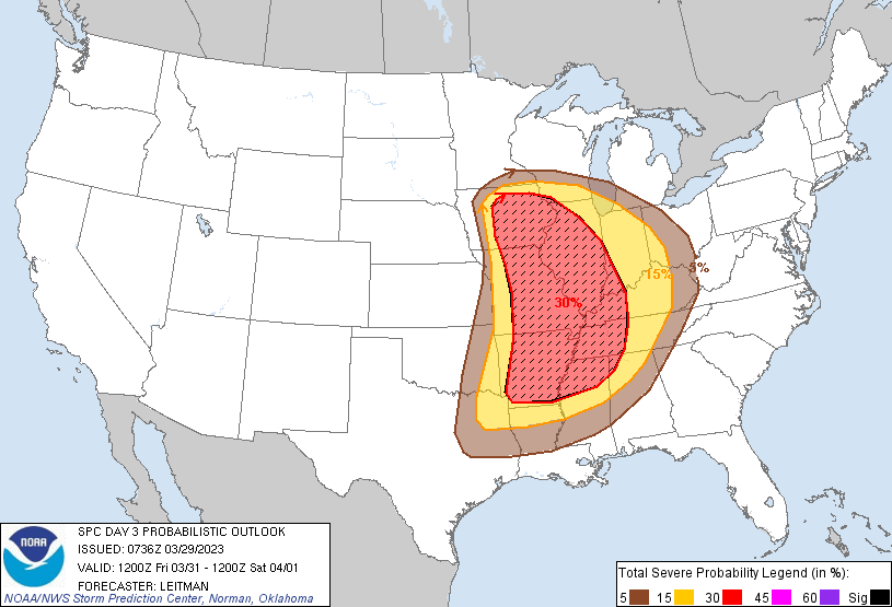
Day 3 Convective Outlook
NWS Storm Prediction Center Norman OK
0236 AM CDT Wed Mar 29 2023
Valid 311200Z - 011200Z
...THERE IS AN ENHANCED RISK OF SEVERE THUNDERSTORMS ACROSS PORTIONS
OF THE MID-MISSISSIPPI VALLEY TO THE MID-SOUTH...
...SUMMARY...
Potentially intense and widespread severe thunderstorms are expected
Friday afternoon into the overnight hours across portions of the
Middle Mississippi Valley and Mid-South vicinity, eastward to the
Lower Ohio and Tennessee Valleys. Damaging gusts and tornadoes will
be the main hazards with this activity.
...Arklatex to the Mid-MS Valley and eastward to the OH/TN
Valleys...
Widespread, regional episode of severe thunderstorms is possible on
Friday.
An intense mid/upper trough is forecast to eject eastward across the
Plains to the central U.S. on Friday. Intense deep-layer
southwesterly flow will accompany this system, with a 100+ kt 500 mb
jet expanding over much of the Midwest. As the upper trough deepens
during the afternoon and evening, a 60-70 kt southwesterly low-level
jet will overspread much of the risk area. These flow fields will
favor a fast-moving squall line shifting across the Mid-MS
Valley/Mid-South toward the Lower OH and TN Valleys.
At the surface, strong southerly low-level flow will transport 60s F
dewpoints northward. Near-60 F dewpoints are expected as far north
as eastern IA to northern IL and then central IN as the surface low
tracks east/northeast from IA early in the day, to southern Ontario
by Saturday morning. While some questions remain regarding moisture
with north and east extent into the OH Valley, forecast soundings
indicate at least a few hundred J/kg MLCAPE will exist during the
evening as far east as the I-65 corridor in KY/TN. Given intense
flow fields, a threat for damaging gusts will persist from MO/IA
into the Lower OH Valley.
Across IA/MO, initial supercell development is possible near the
surface low/triple point. Fast moving storms may produce possibly
significant damaging gusts and tornadoes. Upscale growth into a QLCS
is expected to occur rapidly given strong forcing/vertical shear.
Further south into the Mid-South and vicinity, large-scale ascent
will be somewhat weaker further removed from the upper trough.
However, flow fields will remain intense and a mixed mode of
supercells and linear convection is expected. All severe hazards
(damaging gusts, tornadoes and isolated hail) are expected by late
afternoon into the evening hours.
..Leitman.. 03/29/2023
CLICK TO GET WUUS03 PTSDY3 PRODUCT
NOTE: THE NEXT DAY 3 OUTLOOK IS SCHEDULED BY 0730Z