Probability of damaging thunderstorm winds or wind gusts of 50 knots or higher within 25 miles of a point. Hatched Area: 10% of greater probability of wind gusts 65 knots or greater within 25 miles of a point.
Indianapolis, IN...Milwaukee, WI...Nashville, TN...Kansas City, MO...Louisville, KY...
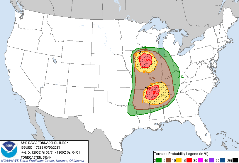
   SPC AC 301732

   Day 2 Convective Outlook
   NWS Storm Prediction Center Norman OK
   1232 PM CDT Thu Mar 30 2023

   Valid 311200Z - 011200Z

   ...THERE IS A MODERATE RISK OF SEVERE THUNDERSTORMS ACROSS EASTERN
   IOWA INTO NORTHWEST ILLINOIS AND FAR NORTHEAST MISSOURI...AND ALSO
   ACROSS NORTHEAST ARKANSAS...THE MISSOURI BOOTHEEL...EXTREME WESTERN
   KENTUCKY...WESTERN TENNESSEE...AND FAR NORTHWEST MISSISSIPPI...

   ...SUMMARY...
   Intense and widespread severe thunderstorms are expected Friday
   afternoon into the overnight hours across portions of the Middle
   Mississippi Valley and Mid-South vicinity, eastward to the Lower
   Ohio and Tennessee Valleys. Intense, damaging gusts and several
   tornadoes (some strong and long-track) are expected.

   ...A regional outbreak of severe storms is expected on Friday across
   parts of the Mid-Mississippi Valley and also into the Mid-South...

   ...Synopsis...
   A deep mid/upper-level trough and attendant 100 kt midlevel jet will
   move quickly eastward from the central Plains into parts of the MS
   Valley and Midwest on Friday. A surface low will deepen as it moves
   across IA toward the Great Lakes region, as a cold front sweeps
   eastward through parts of the Great Plains into the mid-MS Valley.
   In advance of the cold front, low-level moisture will stream
   northward across a broad warm sector from the ArkLaTex region into
   parts of the lower/mid MS Valley and Midwest.

   ...Mid-MS Valley vicinity into IN/lower MI...
   Rapid destabilization and increasing large-scale ascent will support
   thunderstorm development by early/mid afternoon across parts of IA
   into northern MO. Very strong deep-layer shear (effective shear in
   excess of 60 kt) and MLCAPE increasing to 1000-1500 J/kg (locally
   greater) will support organized convection, with initial supercell
   development expected somewhere over central IA into north-central
   MO. Very large hail will be the initial threat, given steep midlevel
   lapse rates and cold temperatures aloft.

   Some uncertainty remains regarding the convective mode evolution
   with time, but a few semi-discrete supercells are expected to move
   into an environment with stronger low-level shear/SRH across eastern
   IA into northwest IL by late afternoon, posing a threat for a couple
   strong tornadoes. Evolution into small clusters or bowing segments
   is expected, resulting in an increasing threat of severe/damaging
   winds in addition to a continued threat of a few tornadoes and
   sporadic hail.

   Organized convection will spread eastward into parts of IN/southern
   MI Friday night. Instability will weaken with eastward extent, but
   some threat for damaging wind and a couple of tornadoes will persist
   before a more definitive weakening trend occurs overnight into early
   Saturday morning.

   ...ArkLaTex/Mid South vicinity into the TN/lower OH Valleys...
   A concerning scenario still appears possible across portions of the
   MO Bootheel, northeast AR, western TN/KY and far northwest MS
   vicinity during the afternoon/evening. At least mid-60s F dewpoints
   are expected beneath modest midlevel lapse rates. This will support
   1500-2000 J/kg MLCAPE amid intense vertical shear. Forecast
   soundings indicate 0-1 km SRH increasing to around 400 m2/s2 by
   early afternoon. Thunderstorms are expected to develop by early
   afternoon ahead of the cold front within a pre-frontal
   trough/low-level confluence zone. Storm motion near 50 kt with
   supercell wind profiles will support cells capable of significant
   and long-track tornadoes. With time, upscale growth into a QLCS is
   expected, and intense wind gusts will be possible in addition to
   mesovortex tornadoes. The threat for damaging gusts and a few
   line-embedded tornadoes will spread into parts of the TN and lower
   OH Valleys Friday night, with a gradual weakening trend eventually
   expected overnight as storms move into increasingly weak buoyancy
   with eastward extent.

   ..Dean.. 03/30/2023

   CLICK TO GET WUUS02 PTSDY2 PRODUCT

   NOTE: THE NEXT DAY 2 OUTLOOK IS SCHEDULED BY 0600Z