Philadelphia, PA...Baltimore, MD...Washington, DC...Virginia Beach, VA...Raleigh, NC...
SLIGHT
121,929
29,285,082
New York, NY...Charlotte, NC...Newark, NJ...Jersey City, NJ...Rochester, NY...
MARGINAL
335,111
29,057,333
New Orleans, LA...Pittsburgh, PA...Buffalo, NY...Baton Rouge, LA...Shreveport, LA...
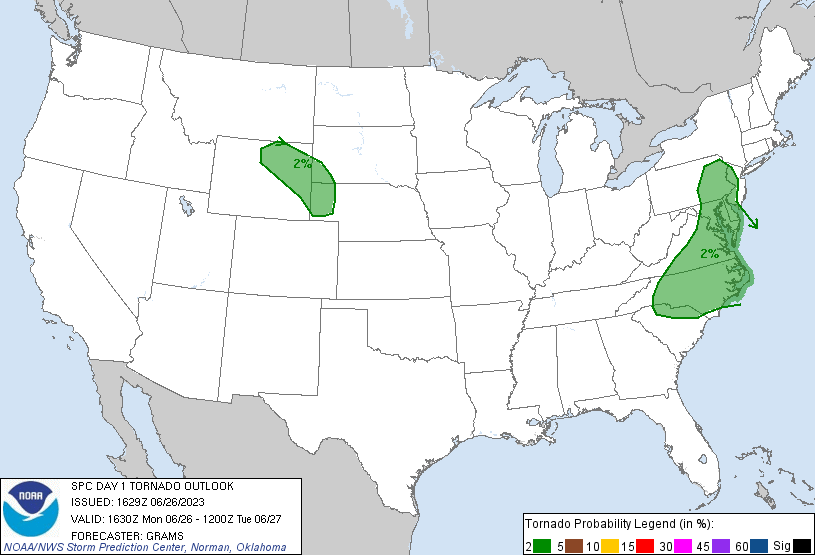
Probabilistic Tornado Graphic
Probability of a tornado within 25 miles of a point. Hatched Area: 10% or greater probability of EF2 - EF5 tornadoes within 25 miles of a point.
Day 1 Tornado Risk
Area (sq. mi.)
Area Pop.
Some Larger Population Centers in Risk Area
2 %
146,797
33,689,290
Philadelphia, PA...Baltimore, MD...Charlotte, NC...Washington, DC...Virginia Beach, VA...
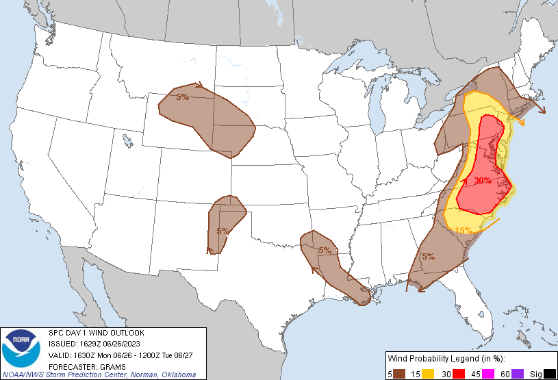
Probabilistic Damaging Wind Graphic
Probability of damaging thunderstorm winds or wind gusts of 50 knots or higher within 25 miles of a point. Hatched Area: 10% of greater probability of wind gusts 65 knots or greater within 25 miles of a point.
Day 1 Wind Risk
Area (sq. mi.)
Area Pop.
Some Larger Population Centers in Risk Area
30 %
78,995
27,911,576
Philadelphia, PA...Baltimore, MD...Washington, DC...Virginia Beach, VA...Raleigh, NC...
15 %
86,494
28,815,732
New York, NY...Charlotte, NC...Newark, NJ...Jersey City, NJ...Rochester, NY...
5 %
354,087
28,212,547
New Orleans, LA...Pittsburgh, PA...Baton Rouge, LA...Shreveport, LA...Columbus, GA...
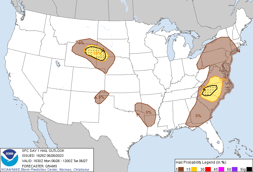
Probabilistic Large Hail Graphic
Probability of hail 1" or larger within 25 miles of a point. Hatched Area: 10% or greater probability of hail 2" or larger within 25 miles of a point.
New York, NY...Philadelphia, PA...Baltimore, MD...Washington, DC...Virginia Beach, VA...
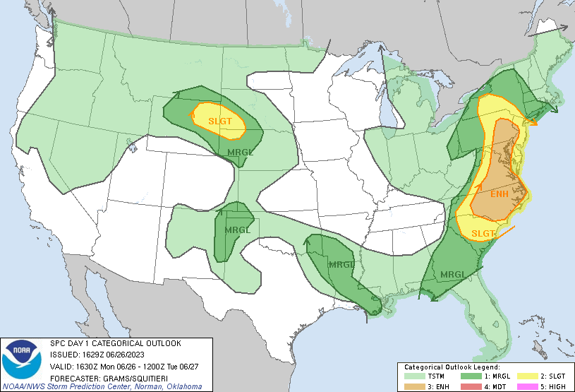
   SPC AC 261629

   Day 1 Convective Outlook
   NWS Storm Prediction Center Norman OK
   1129 AM CDT Mon Jun 26 2023

   Valid 261630Z - 271200Z

   ...THERE IS AN ENHANCED RISK OF SEVERE THUNDERSTORMS NC TO EASTERN
   PA...

   ...THERE IS A SLIGHT RISK OF SEVERE THUNDERSTORMS NORTHEAST WY TO
   NORTHWEST NE...

   ...SUMMARY...
   Scattered damaging winds are most likely from the Carolinas to parts
   of the Mid-Atlantic and Northeast States through this evening.

   ...Carolinas to southern VA...
   The more favorable thermodynamic and kinematic environment will be
   across this portion of the broader severe threat in the East. In the
   wake of a couple MCVs progressing through the central portions of
   Carolinas and VA, nearly full insolation across the western portions
   of these states, coincident with moderately steep mid-level lapse
   rates around 7 C/km, will support moderate buoyancy with MLCAPE of
   1500-2500 J/kg towards early evening. The most consistent signal for
   scattered thunderstorm development is across the higher terrain of
   western NC later this afternoon. While low-level shear will be weak,
   a belt of 35-45 kt 500-mb westerlies will support a few cells with
   mid-level updraft rotation, mainly early before convection tends to
   consolidate into one or more organized clusters. This will likely
   support multiple swaths of damaging winds, centered mainly on the
   Piedmont, before convection tends to gradually weaken across the
   coastal plain tonight.

   ...Mid-Atlantic/Northeast States...
   Mid-level westerlies should be weaker north of southern VA, and
   become increasingly meridional from PA northward, yielding a more
   marginal deep-layer shear environment relative to farther south. In
   addition, isolated to scattered thunderstorms are already ongoing
   across parts of NJ/NY/PA and this will tend to subdue greater
   destabilization with north and east extent. The primary severe
   threat within this region will likely emanate from a later afternoon
   round of thunderstorms that form over the higher terrain from
   central PA to western VA. Morning CAM guidance is more consistent
   with convection being maintained east across eastern PA/central MD
   and parts of the DE and Potomac Valleys where multicell clustering
   should support scattered damaging winds. An MCV over north-central
   VA and relative instability minimum in its vicinity may be
   suppressive to maintaining multicell clustering into the Delmarva
   region later today.

   ...Lee of the north-central Rockies and Black Hills...
   A narrow zone of moderate low-level moisture return is expected to
   persist over the central High Plains beneath a low-amplitude
   mid-level ridge. Isolated to scattered thunderstorms appear most
   likely to develop along the northern periphery of this confined
   buoyancy plume where steep mid-level lapse rates support MLCAPE of
   1000-2000 J/kg. A belt of moderate westerly mid-level flow between
   strong jets over the Southwest and Mid-MS Valley should be adequate
   to support a few supercells. Significant severe hail will be the
   main threat initially, especially with potential for a long-track
   supercell. An attempt at clustering towards the Black Hills/NE
   Panhandle vicinity might occur as the High Plains low-level jet
   strengthens this evening, but the confined spatial extent of the
   buoyancy plume and nocturnal increase in MLCIN yields low confidence
   in maintaining severe coverage beyond an isolated threat tonight.

   ...Ark-La-Tex vicinity...
   In the wake of a decaying MCS over southeast LA (see MCD 1281 for
   near-term discussion), regenerative convection may yield an isolated
   severe hail threat for a few more hours, but convection should
   become more suppressed later this afternoon amid difluent low-level
   flow. A separate round of elevated convection is anticipated
   overnight with weak 850-700 warm theta-e advection. Isolated large
   hail may occur initially owing to the large elevated buoyancy, but
   deep-layer shear magnitude/orientation will tend to favor a
   predominant cluster mode which should serve to marginalize the
   overall severe hail threat and support isolated damaging winds.

   ...Southern High Plains...
   Isolated storm development is possible across the southern High
   Plains, within a hot and well-mixed environment. Any deep convection
   would pose a threat for microbursts and perhaps marginally severe
   hail, though storm longevity appears limited at this time within
   this weakly forced regime.

   ..Grams/Squitieri.. 06/26/2023

   CLICK TO GET WUUS01 PTSDY1 PRODUCT

   NOTE: THE NEXT DAY 1 OUTLOOK IS SCHEDULED BY 2000Z