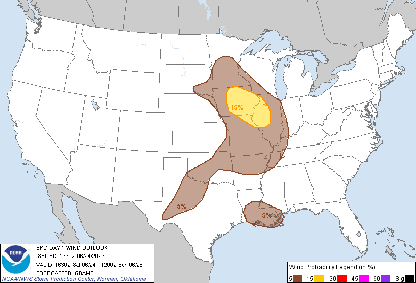
Probability of damaging thunderstorm winds or wind gusts of 50 knots or higher within 25 miles of a point. Hatched Area: 10% of greater probability of wind gusts 65 knots or greater within 25 miles of a point.
Day 1 Wind Risk
Area (sq. mi.)
Area Pop.
Some Larger Population Centers in Risk Area
15 %
61,933
4,121,105
Des Moines, IA...Cedar Rapids, IA...Springfield, IL...Peoria, IL...Davenport, IA...
5 %
370,980
34,055,894
Memphis, TN...Oklahoma City, OK...Kansas City, MO...New Orleans, LA...Omaha, NE...
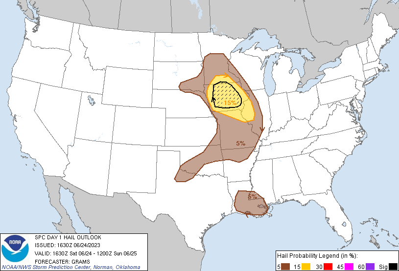
Probabilistic Large Hail Graphic
Probability of hail 1" or larger within 25 miles of a point. Hatched Area: 10% or greater probability of hail 2" or larger within 25 miles of a point.
Day 1 Hail Risk
Area (sq. mi.)
Area Pop.
Some Larger Population Centers in Risk Area
SIG SEVERE
31,920
1,950,406
Des Moines, IA...Cedar Rapids, IA...Waterloo, IA...Iowa City, IA...Ames, IA...
15 %
79,508
3,822,726
Des Moines, IA...Cedar Rapids, IA...Davenport, IA...Waterloo, IA...Iowa City, IA...
5 %
245,649
22,756,716
Oklahoma City, OK...Kansas City, MO...New Orleans, LA...Omaha, NE...Tulsa, OK...
SPC AC 241630
Day 1 Convective Outlook
NWS Storm Prediction Center Norman OK
1130 AM CDT Sat Jun 24 2023
Valid 241630Z - 251200Z
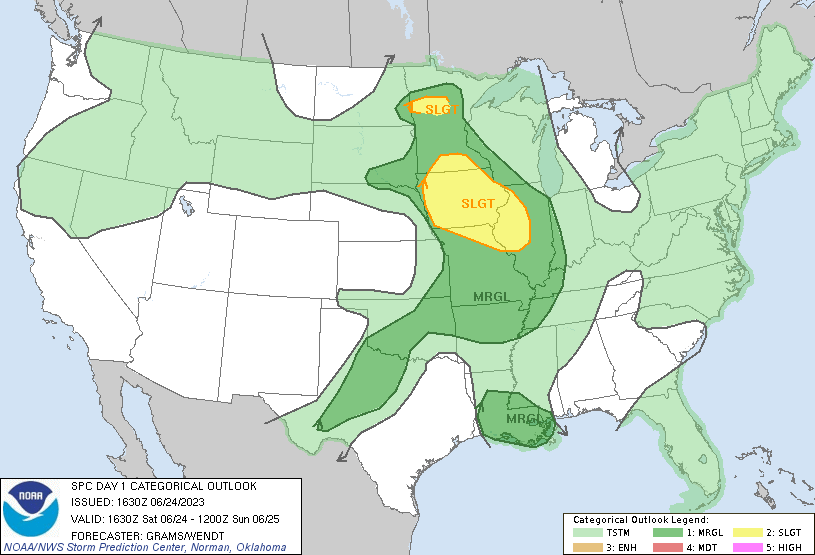
...THERE IS A SLIGHT RISK OF SEVERE THUNDERSTORMS PARTS OF THE UPPER
MIDWEST TO THE MID-MS VALLEY...
...SUMMARY...
Scattered severe thunderstorms are most likely across portions of
Minnesota and Iowa into the Mid-Mississippi Valley through this
evening. Brief tornadoes, large hail, and damaging winds will be
possible.
...Upper Midwest to Mid-MS Valley...
Remnants of a decaying MCS persist in eastern IA with residual cloud
cover and convective redevelopment in its wake across central into
southwest IA. More pronounced insolation has occurred over northwest
IA and parts of eastern NE. This will likely yield a moderately
unstable air mass with MLCAPE approaching 2500 J/kg in a few hours.
Morning guidance is insistent on surface-based thunderstorm
development occurring by early afternoon, which appears a bit too
soon given the lingering morning convection/cloudiness, but is
plausible owing to modest mid-level lapse rates/EML. As such,
confidence is below-average with regard to timing and evolution of
this afternoon's severe threat.
Downstream of a 60-65 kt 500-mb westerly jetlet centered on NE,
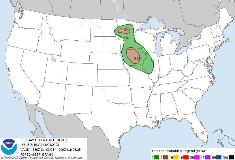
deep-layer shear will support potential for several supercells. A
few-hour window for a couple of these to produce tornadoes may
overlap along the residual outflow boundary before convection likely
consolidates into clusters and low-level winds become more veered
into the evening. East to southeast-moving clusters may develop into
a semi-organized MCS during the evening and yield a strong to
isolated severe wind threat across the Mid-MS Valley. This activity
should gradually weaken tonight after eventually outpacing greater
instability/buoyancy to its west.
A separate area of lower-topped tornado potential is evident in
northwest/north-central MN along the surface warm front that will
extend east of the primary cyclone centered near the northeast
SD/southeast ND border area. Backed surface winds that veer with
height will support enlarged low-level hodograph curvature. In
conjunction with low LCLs, these factors may support a threat for
brief tornadoes during the late afternoon to early evening.
...West TX to the Ozark Plateau...
Isolated to scattered high-based thunderstorms will develop during
the late afternoon to early evening across at least west TX, and
perhaps across parts of OK this evening into tonight. With a stout
mid-level anticyclone centered along the Trans-Pecos portion of the
Rio Grande, deep-layer shear will be progressively stronger with
northeast extent towards the Ozark Plateau. Sporadic severe gusts
from microbursts will be the main threat in TX, with a conditional
threat for isolated severe wind/hail into the Ozark Plateau.
...LA vicinity...
Despite weak low-level shear, a belt of modest mid-level northerlies
will support potential for an isolated severe wind and hail threat
as isolated to scattered thunderstorms develop this afternoon within
the boundary-layer moisture/buoyancy gradient between LA/MS.
..Grams/Wendt.. 06/24/2023
CLICK TO GET WUUS01 PTSDY1 PRODUCT
NOTE: THE NEXT DAY 1 OUTLOOK IS SCHEDULED BY 2000Z