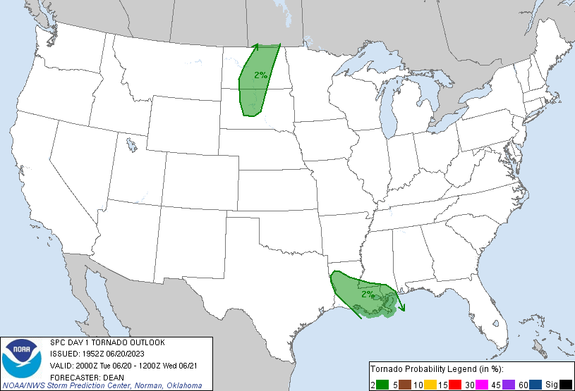
Probability of a tornado within 25 miles of a point. Hatched Area: 10% or greater probability of EF2 - EF5 tornadoes within 25 miles of a point.
Day 1 Tornado Risk
Area (sq. mi.)
Area Pop.
Some Larger Population Centers in Risk Area
2 %
88,624
4,316,849
New Orleans, LA...Baton Rouge, LA...Metairie, LA...Lafayette, LA...Gulfport, MS...
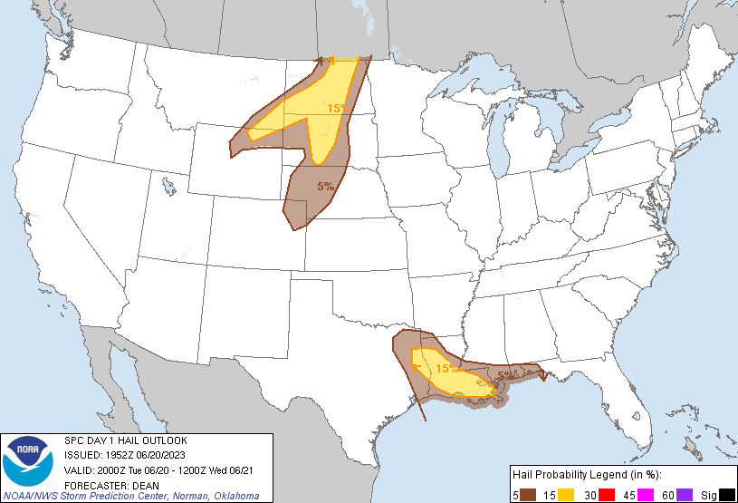
Probabilistic Damaging Wind Graphic
Probability of damaging thunderstorm winds or wind gusts of 50 knots or higher within 25 miles of a point. Hatched Area: 10% of greater probability of wind gusts 65 knots or greater within 25 miles of a point.
Day 1 Wind Risk
Area (sq. mi.)
Area Pop.
Some Larger Population Centers in Risk Area
15 %
103,797
4,156,928
New Orleans, LA...Baton Rouge, LA...Metairie, LA...Lafayette, LA...Lake Charles, LA...
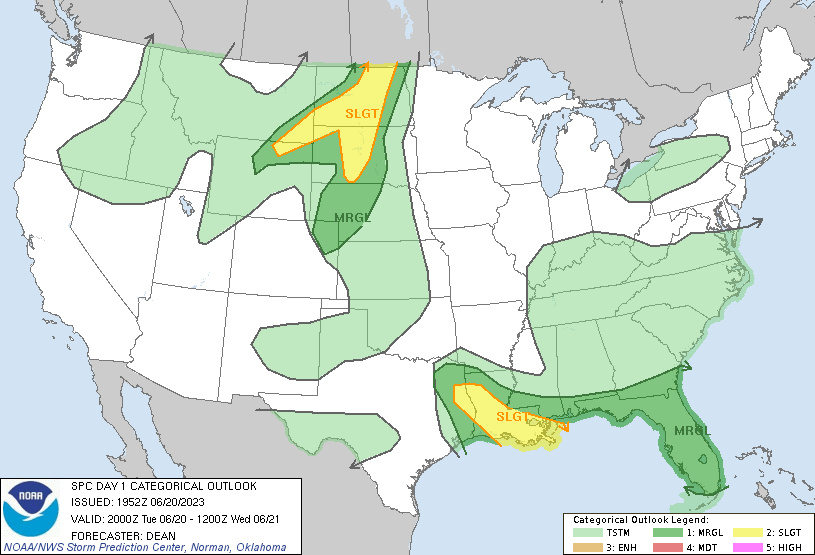
   SPC AC 201952

   Day 1 Convective Outlook
   NWS Storm Prediction Center Norman OK
   0252 PM CDT Tue Jun 20 2023

   Valid 202000Z - 211200Z

   ...THERE IS A SLIGHT RISK OF SEVERE THUNDERSTORMS OVER PARTS OF
   LOUISIANA AND EAST TEXAS...AND ALSO OVER PORTIONS OF EASTERN MONTANA
   AND THE DAKOTAS...

   ...SUMMARY...
   Isolated to scattered severe thunderstorms will be possible late
   this afternoon into tonight across parts of the northern Plains, and
   also from east Texas to the Southeast.  Damaging winds and large
   hail should be the main threats.

   ...20Z Update...
   The primary outlook change is to trim the northeastern portion of
   the southern Slight Risk area across parts of southern MS, in the
   wake of extensive convection that has recently moved into southeast
   LA. Otherwise, see the previous discussion below for more
   information, and MCD 1175 for more information regarding the
   short-term threat across parts of WY.

   Outside of the Marginal Risk area, elevated storms may develop late
   tonight across south-central NE into north-central KS. A hail threat
   cannot be ruled out with the strongest storms, due to the presence
   of steep midlevel lapse rates and favorable elevated buoyancy.
   However, with uncertainty regarding storm placement and coverage,
   and only modest deep-layer shear in place, confidence remains too
   low to extend severe probabilities into the region at this time.

   ..Dean.. 06/20/2023

   .PREV DISCUSSION... /ISSUED 1124 AM CDT Tue Jun 20 2023/

   ...LA/TX...
   Morning water vapor imagery shows a dominant ridge aloft extending
   from the southern Plains into the upper Midwest, with a band of
   relatively fast northwesterly mid-level flow from MO/AR into LA/MS.
   An extremely moist low-level air mass is present beneath the
   southwesterly fringe of the strong winds aloft, with dewpoints in
   the upper 70s to near 80F over parts of east TX and much of LA.
   Strong heating will yield very large CAPE values this afternoon and
   promote scattered thunderstorm development.  Storms will mainly
   develop along/ahead of a southwestward sagging surface boundary that
   currently extends from northern LA into southern MS.  A few of the
   cells will likely be severe, with hail and damaging winds possible
   through the evening.

   ...SD/ND...
   A weak surface cold front currently extends from north central ND
   into southeast SD.  Substantial low-level moisture along and east of
   the front, coupled with full sunshine, will result in moderate CAPE
   by afternoon.  Large scale forcing for ascent associated with a
   shortwave trough currently over northwest CO will overspread the
   area this afternoon, promoting scattered thunderstorms along the
   front.  Low-level winds are relatively weak, but sufficient deep
   layer shear will promote organized multicell or a few supercell
   storms capable of large hail and damaging winds.

   ...Eastern MT/western ND...
   Model guidance shows a well-defined 60-70kt mid-level jet over
   northern NV.  Forcing associated with this feature is moving across
   western WY and is expected to result in a scattered thunderstorms
   over the Big Horn mountains by mid-afternoon.  These storms will
   track northeastward into southeast MT and eventually western ND
   tonight.  A cluster of fast-moving supercells or bowing structures
   (similar to yesterday) is possible, capable of damaging winds and
   hail.

   CLICK TO GET WUUS01 PTSDY1 PRODUCT

   NOTE: THE NEXT DAY 1 OUTLOOK IS SCHEDULED BY 0100Z