New Orleans, LA...Columbus, GA...Tallahassee, FL...Metairie, LA...Gainesville, FL...
Probabilistic Damaging Wind Graphic
Probability of damaging thunderstorm winds or wind gusts of 50 knots or higher within 25 miles of a point. Hatched Area: 10% of greater probability of wind gusts 65 knots or greater within 25 miles of a point.
SPC AC 191958
Day 1 Convective Outlook
NWS Storm Prediction Center Norman OK
0258 PM CDT Mon Jun 19 2023
Valid 192000Z - 201200Z
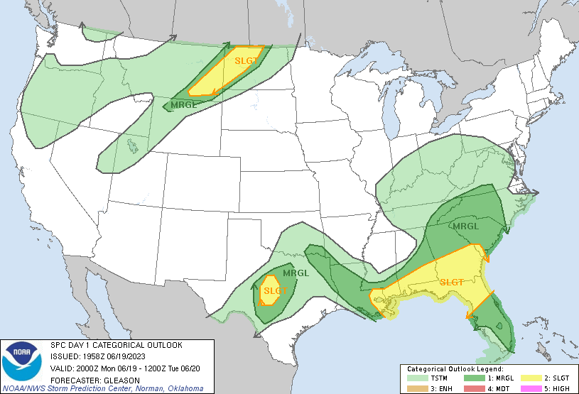
...THERE IS A SLIGHT RISK OF SEVERE THUNDERSTORMS ACROSS PARTS OF
THE SOUTHEAST...NORTHERN PLAINS...AND CENTRAL TEXAS...
...SUMMARY...
Severe thunderstorms are possible today over parts of the Southeast,
central Texas, Arklatex, and northern Plains.
...20Z Update...
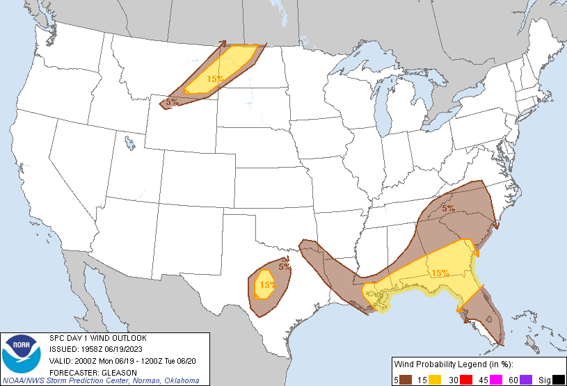
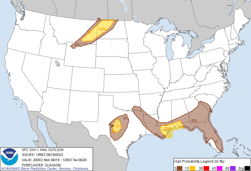
The only meaningful change to the outlook has been to introduce a
small Slight Risk across parts of central TX. Temperatures have
soared into the low to mid 100s amid upper 60s to low 70s surface
dewpoints to the east of a dryline. Recent visible satellite imagery
shows convective initiation occurring east of San Angelo TX. Even
though large-scale ascent will remain weak, any thunderstorms that
can form and be sustained may become supercellular given 35-40 kt of
deep-layer shear due to modestly enhanced mid/upper-level
northwesterly winds. An associated threat for very large hail should
exist given the presence of very strong instability and steep
mid-level lapse rates. Severe downdraft winds may also occur. For
more details, see recently issued Mesoscale Discussion 1166 and
Severe Thunderstorm Watch 340.
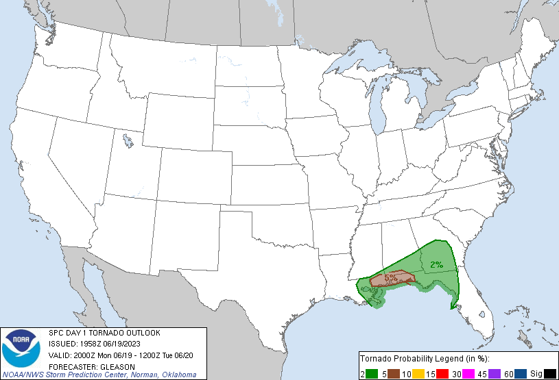
Across the Southeast, tornado potential will likely remain focused
along/very near the Gulf Coast in MS/AL and the FL Panhandle.
Multiple areas of low-level rotation, with occasional debris
signatures, have been noted with convection occurring across these
areas given favorable low-level shear noted on recent VWPs from
KMOB/KEVX, etc... In the wake of earlier thunderstorms, a separate
area of convection has also developed this afternoon across
south-central AL. This activity may pose an isolated threat for
damaging winds and hail through the rest of the afternoon into this
evening as the boundary layer attempts to re-destabilize. See
Mesoscale Discussion 1165 for more details on the near-term severe
threat across the central Gulf Coast states.
No changes have been made to the Slight Risk across parts of eastern
MT into ND.
..Gleason.. 06/19/2023
.PREV DISCUSSION... /ISSUED 1112 AM CDT Mon Jun 19 2023/
...Southern MS/AL to FL Panhandle...
A large upper trough is present today over much of the eastern
states, with a corridor of 30-40 knot mid-level winds extending from
AR into the central Gulf Coast region. Ample low-level moisture
remains across much of the southeast, but multiple bouts of
convection have pushed the main outflow boundary southward into
southern MS/AL and the FL Panhandle. Strong afternoon heating will
help to establish moderate to strong instability along this axis
where re-development of widely scattered strong/severe storms are
expected. Weak forcing mechanisms suggest limited coverage of
intense storms, but sufficient deep-layer vertical shear and
proximity to boundaries may result in isolated supercells capable of
hail, damaging wind gusts, and perhaps a tornado.
...Southeast GA/Northeast FL...
A persistent linear MCS continues to track eastward across southern
GA and northern FL. Strong heating ahead of the line has resulted
in moderate CAPE values and sufficient westerly flow aloft to pose a
risk of locally gusty/damaging winds for a few more hours until the
line moves offshore. Cooler temperatures in the wake of the line
should limit the redevelopment of severe storms later today.
...MT/ND...
Fast southwesterly flow aloft extends across the northern Rockies
and High Plains today. A band of mid/high clouds lies from northern
WY into eastern MT and western ND. A consensus of morning model
solutions indicate that strong heating along and east of the
eastern edge of this cloud cover will result in a corridor of steep
low-level lapse rates and sufficient CAPE for scattered thunderstorm
development. Fast-moving supercell and bowing structures appear
likely this afternoon and evening as storms track from eastern MT
into western ND. Damaging winds and hail are the main risks.
...Central TX...
Hot/humid conditions along the surface dryline over central TX will
pose some risk of isolated thunderstorms by mid/late afternoon.
While coverage of these storms may be quite limited, any storm that
forms in the extremely unstable air will pose a risk of large hail
and damaging winds.
CLICK TO GET WUUS01 PTSDY1 PRODUCT
NOTE: THE NEXT DAY 1 OUTLOOK IS SCHEDULED BY 0100Z