Probability of damaging thunderstorm winds or wind gusts of 50 knots or higher within 25 miles of a point. Hatched Area: 10% of greater probability of wind gusts 65 knots or greater within 25 miles of a point.
Jacksonville, FL...Oklahoma City, OK...Atlanta, GA...Tulsa, OK...Birmingham, AL...
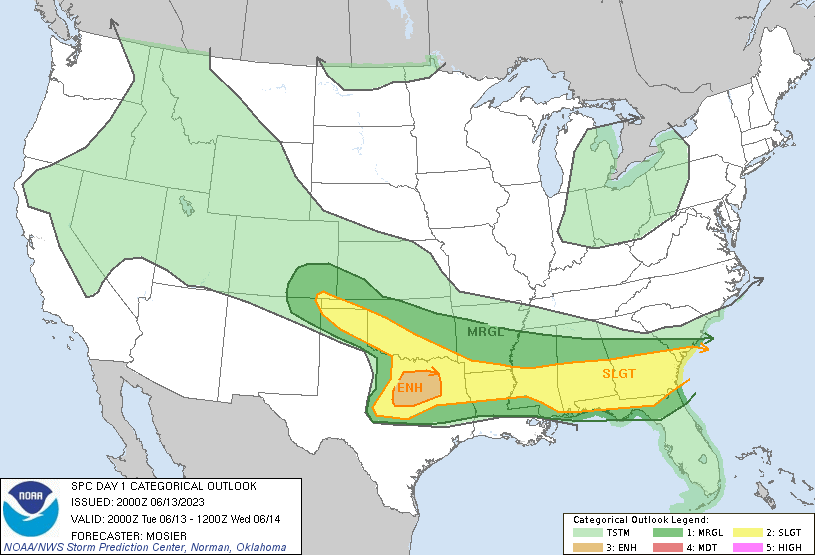
   SPC AC 132000

   Day 1 Convective Outlook
   NWS Storm Prediction Center Norman OK
   0300 PM CDT Tue Jun 13 2023

   Valid 132000Z - 141200Z

   ...THERE IS AN ENHANCED RISK OF SEVERE THUNDERSTORMS ACROSS
   NORTH-CENTRAL TX...

   ...SUMMARY...
   Severe thunderstorms are still expected this afternoon into tonight
   from parts of the southern High Plains to the Southeast, with large
   hail and damaging winds possible. Highest severe thunderstorm
   coverage is expected over north Texas.

   ...20Z Update...

   ...Southern Plains into the Southeast today into tonight...
   Warm, moist, and strongly unstable air mass remain in place from the
   southern Plains through the Southeast. Numerous strong to severe
   thunderstorms are already ongoing, with 4 Severe Thunderstorm
   Watches (280, 281, and 282) currently in place.

   The stronger shear is expected to stay over western portions of the
   region, with mesoanalysis currently estimating effective bulk shear
   around 60 kt from north/central TX across LA. Recent VAD from FWS
   sampled 63 kt of effective bulk shear. Robust buoyancy exists over
   this region as well, and the overall environment appears favorable
   for splitting supercells. Very large hail will remain the primary
   severe risk through the evening.

   Farther east, thunderstorms have trended towards more linear
   structures across southern AL and southern GA. This trend is
   expected to continue, with some additional ascent provided by the
   convectively enhanced vorticity maximum moving through the region.
   As such, the severe threat is expected to continue across the region
   and into adjacent parts of the FL Panhandle/northern FL.

   ...Southern High Plains into Oklahoma this afternoon and evening...
   Thunderstorms are expected to continue maturing across southeast
   CO/northwest NM, eventually bringing these storms into the TX/OK
   Panhandle. Moderate buoyancy and shear will support some strong to
   severe storms, and Severe Thunderstorm Watch 283 was recently issued
   to cover this threat. These storms may persist into the evening
   hours, with some potential to remain strong to severe as far east as
   central OK by 06Z. These storms should gradually become elevated
   over time, trending towards mainly a hail risk.

   ..Mosier.. 06/13/2023

   .PREV DISCUSSION... /ISSUED 1135 AM CDT Tue Jun 13 2023/

   ...Synopsis...
   Scattered to widespread thunderstorms are in progress along the
   immediate cool side of an west-to-east oriented baroclinic zone
   located across portions of central TX and extending eastward across
   parts of central MS/AL. These storms persist within a warm-air
   advection regime driven by a veering and gradually weakening
   low-level jet overspreading the Mid South. With time, the upper
   ridge across the southern Plains will subside to a degree, with
   mid-level westerly flow increasing in magnitude. During the mid to
   late afternoon hours, a mid-level impulse embedded in the broader
   westerly flow will eject from the southern Rockies, initiating newer
   rounds of strong to severe thunderstorms along the southern High
   Plains, and across central Texas.

   ...Arklatex into the Southeast today into tonight...
   Strong to potentially severe storms are ongoing within the warm-air
   advection regime. Surface temperatures warming into the 80s F amid
   near 70 F dewpoints will contribute to 3000 J/kg of thin MLCAPE
   (given mediocre mid-level lapse rates). The stronger mid-level flow
   overspreading the region will support elongated hodographs, with
   multicells and short line segments the expected storm modes. Large
   hail will be possible with the stronger cells and a few damaging
   gusts may also occur with storms on the warm side of the baroclinic
   zone, where steeper low-level lapse rates will reside.

   Later tonight, as the low-level jet increases in intensity, warm-air
   advection will encourage elevated thunderstorm development atop a
   stable boundary layer across the Arklatex into the Southeast. Large
   hail will be the main threat with these storms.

   ...Central into northeast Texas this afternoon and evening...
   In the wake of earlier storms, a warm/moist boundary layer is
   expected to develop through the afternoon. As mid-level flow
   intensifies over TX, steep mid-level lapse rates will overspread the
   deepening boundary layer, contributing to strong to extreme
   instability (i.e. 4000+ J/kg of wide CAPE, especially above 700 mb).
   Mainly straight but elongated hodographs will support splitting
   supercell structures later this afternoon. Given the depth of
   buoyancy above the freezing level and 50+ kts of effective bulk
   shear/elongated hodographs, very large hail is likely with the more
   established supercells. Later into the evening/overnight hours,
   elevated supercell structures should persist as they approach the
   Arklatex vicinity, with a continued threat for large hail.

   ...Southern High Plains into Oklahoma this afternoon and evening...
   Upslope flow and the passage of the aforementioned mid-level impulse
   will result in convective initiation along the lee of the southern
   Rockies. The eastward advection of 8-9 C/km lapse rates will support
   at least moderate instability amid elongated hodographs, supporting
   supercell structures capable of producing large hail (a couple
   stones of which may exceed 2 inches in diameter). These storms may
   persist into the evening hours, with some guidance member suggesting
   storms may remain strong to severe as far east as central OK by 06Z.
   By evening, these storms should gradually become elevated, producing
   large hail and perhaps a severe gust.

   CLICK TO GET WUUS01 PTSDY1 PRODUCT

   NOTE: THE NEXT DAY 1 OUTLOOK IS SCHEDULED BY 0100Z