Fort Worth, TX...Arlington, TX...Plano, TX...Irving, TX...Grand Prairie, TX...
Probabilistic Damaging Wind Graphic
Probability of damaging thunderstorm winds or wind gusts of 50 knots or higher within 25 miles of a point. Hatched Area: 10% of greater probability of wind gusts 65 knots or greater within 25 miles of a point.
Day 1 Wind Risk
Area (sq. mi.)
Area Pop.
Some Larger Population Centers in Risk Area
SIG SEVERE
12,479
692,845
College Station, TX...Bryan, TX...Huntsville, TX...Lufkin, TX...Palestine, TX...
Kansas City, MO...New Orleans, LA...Omaha, NE...Wichita, KS...Lincoln, NE...
SPC AC 101954
Day 1 Convective Outlook
NWS Storm Prediction Center Norman OK
0254 PM CDT Sat Jun 10 2023
Valid 102000Z - 111200Z
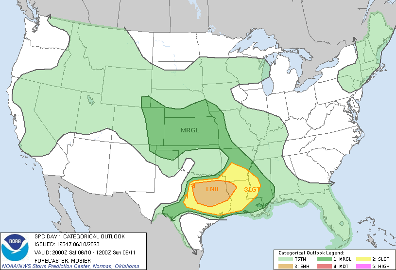
...THERE IS AN ENHANCED RISK OF SEVERE THUNDERSTORMS THIS
AFTERNOON/EVENING FROM THE ARKLATEX INTO CENTRAL TEXAS...
...SUMMARY...
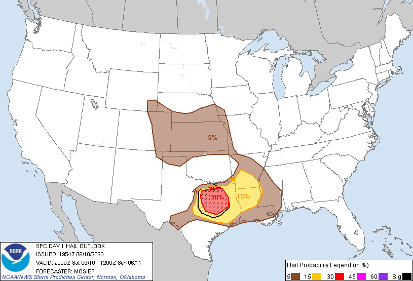
Very large hail of 2-3 inches in diameter, damaging thunderstorm
gusts of 60-75 mph, and a couple of tornadoes will be possible this
afternoon through late evening from the ArkLaTex into central Texas.
...20Z Update...
...North/Central TX...
Recent surface analysis places an outflow boundary from Wise County
southeastward to Ellis/Navarro Counties and then back
eastward/east-northeastward into northwest LA. Cumulus is developing
along this boundary across the southern Metroplex vicinity, and the
air mass here and south is strongly unstable (i.e. MLCAPE 2500+
J/kg). An initially cellular mode is anticipated, with some
supercells possible. Very large hail will be primary threat, but a
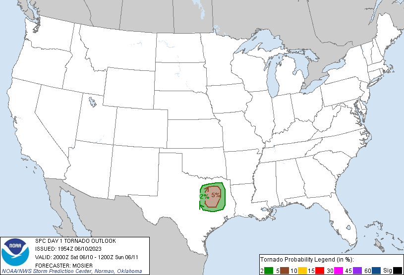
tornado or two is also possible if any storms interact with the
outflow boundary. Expectation is for eventual upscale growth, with
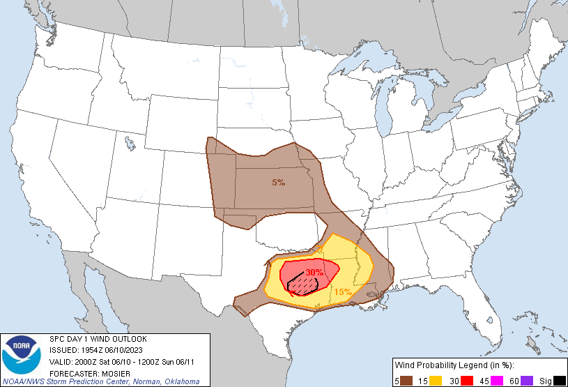
the line then moving southeastward into east/southeast TX. The
threat would transition to damaging gusts during that time, with a
few gusts from 60-75 mph are possible. This area was also addressed
in recently issued MCD #964 and Severe Thunderstorm Watch 262.
...Central Plains/Central High Plains...
Overall expectations across the central High Plains and central
Plains have not changed. Across the central High Plains,
thunderstorms expected to come off the higher terrain and move into
the lower elevations, with an attendant threat for damaging gusts.
Over the central Plains, a strong storm or two is still possible
this evening and overnight as a cold front pushes through the
region.
..Mosier.. 06/10/2023
.PREV DISCUSSION... /ISSUED 1131 AM CDT Sat Jun 10 2023/
...Southern Plains to the lower MS Valley through late evening...
A cluster of thunderstorms is moving southeastward across the
ArkLaTex as of late morning, with an MCV over eastern OK (trailing
the initial convection/outflow). Surface temperatures are warming
into the 80s with boundary-layer dewpoints in the low 70s from
northeast TX into northern LA/southern AR, which is boosting MLCAPE
to the 2000-3000 J/kg range. Vertical shear remains relatively weak
near and ahead of the primary convective band along the outflow, and
the strongest updrafts should remain along the southern flank of the
cluster. Thus, the expectation is for occasional damaging gusts
with precipitation-loaded downdrafts, with a somewhat
outflow-dominant structure to the cluster as is moves southeastward
through the afternoon. Other, more isolated storm clusters with
isolated downburst potential, may occur this afternoon along the
instability gradient into MS.
Farther west, outflow with the morning cluster is moving southward
into north TX. Strong surface heating and a feed of steep midlevel
lapse rates from the west will contribute to strong buoyancy (MLCAPE
> 3000 J/kg) this afternoon, along and south of the outflow
boundary. Additional thunderstorm development appears probable by
mid-late afternoon along the slowing outflow, and storms will
subsequently spread southeastward toward southeast TX before
weakening early tonight. Vertical shear will become sufficient for
supercells along the outflow boundary as a weak midlevel
trough/speed max moves eastward over TX within the southern stream.
The steep lapse rates/large buoyancy, in combination with mainly
straight hodographs and effective bulk shear of 35-40 kt, will
support supercell clusters capable of producing isolated very large
hail of 2-3 inches in diameter. Some upscale growth will be
possible this evening, with a corresponding increase in the threat
for damaging outflow gusts. Any tornado threat will rely on
favorable storm interactions with locally backed flow/stronger
low-level shear along the modifying outflow boundary late this
afternoon.
...Central Plains this afternoon into tonight...
Scattered thunderstorms are expected this afternoon across the
central Plains in associated with remnant MCVs and differential
heating zones. Buoyancy and vertical shear will not be strong, but
isolated/marginal hail/wind events will be possible. Other clusters
of storms may form across the High Plains and move
east-southeastward this evening into tonight. These storms may
produce isolated strong-severe outflow gusts from eastern CO into
KS.
CLICK TO GET WUUS01 PTSDY1 PRODUCT
NOTE: THE NEXT DAY 1 OUTLOOK IS SCHEDULED BY 0100Z