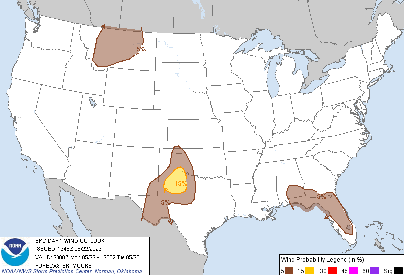
Probability of damaging thunderstorm winds or wind gusts of 50 knots or higher within 25 miles of a point. Hatched Area: 10% of greater probability of wind gusts 65 knots or greater within 25 miles of a point.
SPC AC 221948
Day 1 Convective Outlook
NWS Storm Prediction Center Norman OK
0248 PM CDT Mon May 22 2023
Valid 222000Z - 231200Z
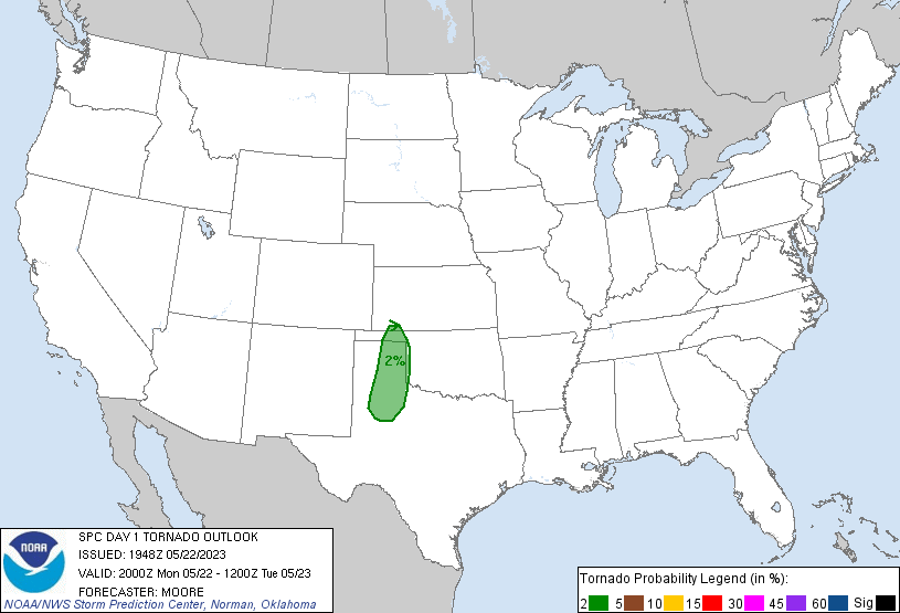
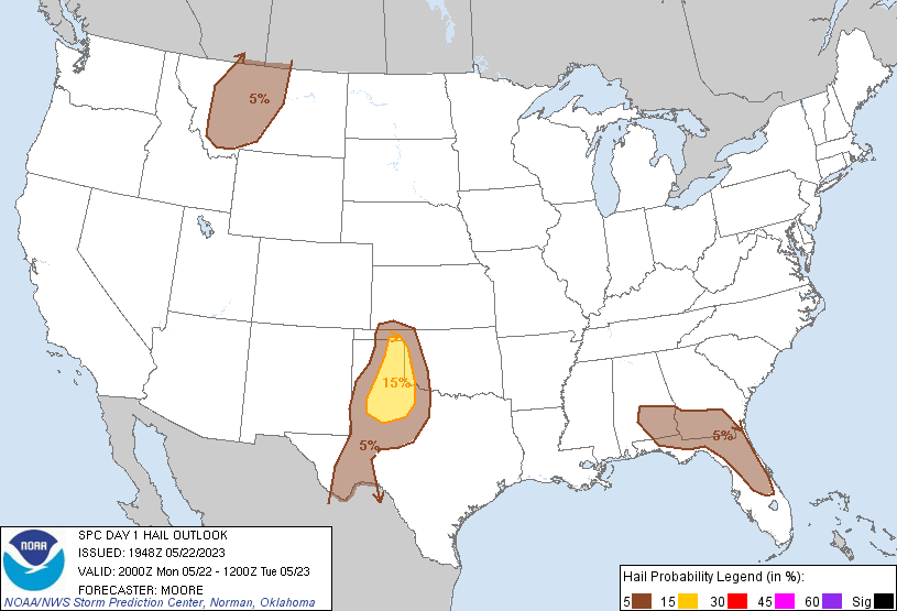
...THERE IS A SLIGHT RISK OF SEVERE THUNDERSTORMS ACROSS THE
NORTHWEST TEXAS VICINITY...
...SUMMARY...
Isolated to scattered severe thunderstorms are likely across the
Oklahoma/Texas Panhandles into northwest Texas through late evening.
Large hail and severe wind gusts will be the primary hazards.
...Southern High Plains...
The previous forecast largely remains on track with only minor
adjustments needed. Wind probabilities were adjusted slightly to
account for where convective initiation is occurring and confidence
in the downstream wind threat is correspondingly higher. See MCD
#838 for additional details on the near-term forecast.
...MT...
Across MT, the initial convection noted in MCD #837 has demonstrated
periods of organization with a bowing segment approaching the Great
Falls, MT area. However, this segment has not maintained consistent
intensity per GOES IR imagery over the past 1-2 hours, and
downstream buoyancy remains uncertain. Confidence in a more
widespread wind threat remains too limited for higher probabilities,
but a few additional strong/severe storms remain probable.
..Moore.. 05/22/2023
.PREV DISCUSSION... /ISSUED 1129 AM CDT Mon May 22 2023/
...TX/OK Panhandles to the Lower Pecos Valley...
An MCV over southwest KS will drift quite slowly east-southeast
through tonight. Modestly enhanced westerly mid-level flow (25-30
kts at 500 mb) will be displaced to the south of this MCV, centered
across the southern TX Panhandle to the Permian Basin. Cloud
coverage is most pronounced close to the MCV, with robust
boundary-layer heating expected from the central/southern TX
Panhandle southward towards the Pecos Valley. This heating will be
coincident with the northwest extent of upper 50s to lower 60s
surface dew points and the eastern extent of the elevated mixed
layer, supporting moderate buoyancy with MLCAPE of 1500-2000 J/kg.
Scattered thunderstorms should develop towards mid-afternoon across
the eastern Panhandles into the South Plains, with more isolated
activity into the Trans-Pecos.
Within the belt of enhanced mid-level flow, adequate effective bulk
shear (from 30-35 kts) and 0-3 km SRH should exist for a few
slow-moving supercells. Flow will largely remain neutral to
decreasing with height above the mid-levels north of the Permian
Basin. A mix of transient supercells and multicell clusters can be
expected, with a tendency for upscale growth along consolidating
outflows by early evening as a modest increase in low-level warm
theta-e advection occurs. Overall setup should favor isolated to
scattered large hail from quarter to golf ball size and 50-70 mph
wind gusts. Any MCS this evening in the western north TX vicinity
should weaken after sunset as it impinges on increasing MLCIN to its
southeast.
...MT...
An upper-level trough will largely remain anchored over the Canadian
to the northern U.S. Rockies during the period, with an embedded
shortwave impulse rotating through north ID/northwest MT to the
southern British Columbia/Alberta region this afternoon. An
attendant surface cold front will push eastward across western MT
and serve as a focus for isolated to scattered high-based
thunderstorm development.
Boundary-layer dew points from the mid to upper 40s suggest MLCAPE
will remain weak from 500-1000 J/kg. Stronger mid to upper-level
flow will be displaced west of the front, and as convection develops
it will further outpace the better flow given the track of the
embedded shortwave impulse. As such, isolated severe hail is
possible mainly early. A few outflow-dominated multicell clusters
should become the predominant mode with a primary threat of
scattered strong to isolated severe wind gusts.
...FL and Northeast Gulf Coast...
A minor mid-level impulse will drift slowly east over MS/AL, with a
diffuse west/east-oriented quasi-stationary front to its southeast.
Scattered thunderstorms are already ongoing along and just north of
this front across south GA into extreme north FL. Additional
thunderstorms will develop shortly along the sea breezes down the
Peninsula, with numerous colliding convective outflows expected
later this afternoon.
Mid-level lapse rates will remain weak south, and more moderate to
the north, with lower-level winds also remaining weak area wide.
Pockets of scattered to broken cloud coverage in the Peninsula and
separately over the FL Panhandle into south AL will support steeper
low-level lapse rates that will favor sporadic strong to severe
outflow gusts of 45-60 mph. Isolated, marginally severe hail will
also be possible, mainly with any cells that can be rooted on
southwest to south-moving outflows.
CLICK TO GET WUUS01 PTSDY1 PRODUCT
NOTE: THE NEXT DAY 1 OUTLOOK IS SCHEDULED BY 0100Z