St. Louis, MO...Cedar Rapids, IA...Springfield, IL...Peoria, IL...Davenport, IA...
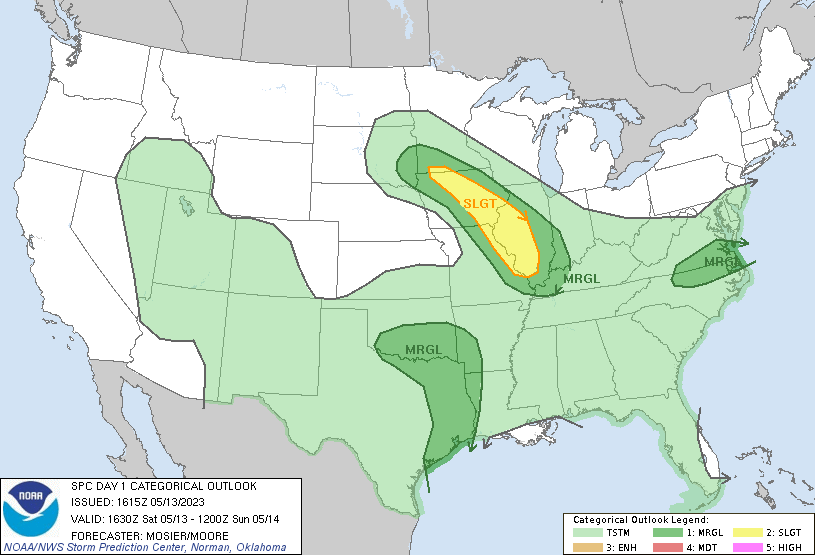
MARGINAL
224,786
26,627,169
Houston, TX...Dallas, TX...Oklahoma City, OK...Virginia Beach, VA...Arlington, TX...
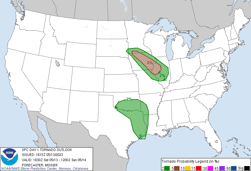
Probabilistic Tornado Graphic
Probability of a tornado within 25 miles of a point. Hatched Area: 10% or greater probability of EF2 - EF5 tornadoes within 25 miles of a point.
Day 1 Tornado Risk
Area (sq. mi.)
Area Pop.
Some Larger Population Centers in Risk Area
5 %
37,060
2,397,444
Cedar Rapids, IA...Peoria, IL...Davenport, IA...Waterloo, IA...Iowa City, IA...
2 %
156,185
19,119,199
Houston, TX...Dallas, TX...Oklahoma City, OK...Arlington, TX...St. Louis, MO...
Probabilistic Damaging Wind Graphic
Probability of damaging thunderstorm winds or wind gusts of 50 knots or higher within 25 miles of a point. Hatched Area: 10% of greater probability of wind gusts 65 knots or greater within 25 miles of a point.
Day 1 Wind Risk
Area (sq. mi.)
Area Pop.
Some Larger Population Centers in Risk Area
15 %
54,943
5,881,981
St. Louis, MO...Cedar Rapids, IA...Springfield, IL...Peoria, IL...Davenport, IA...
5 %
226,130
26,653,775
Houston, TX...Dallas, TX...Oklahoma City, OK...Virginia Beach, VA...Arlington, TX...
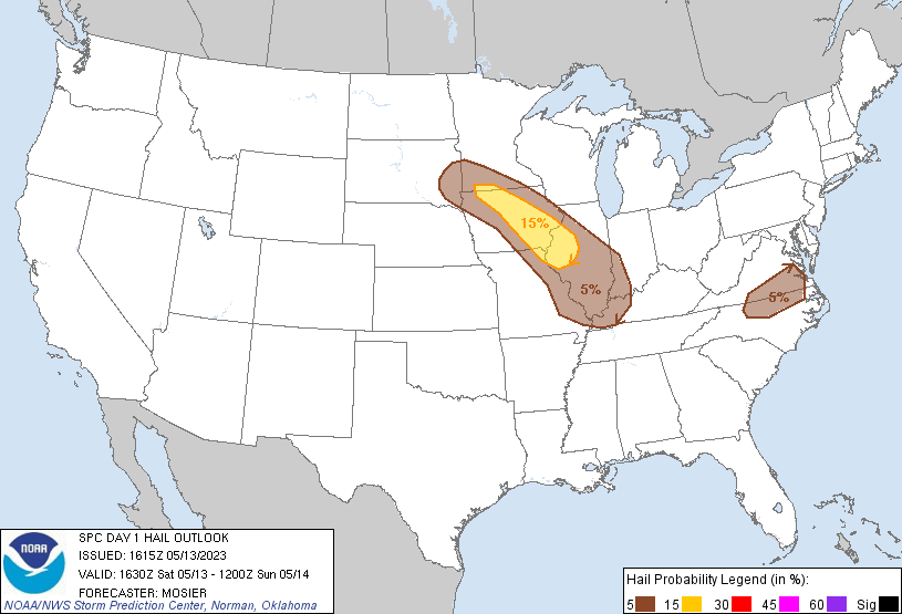
Probabilistic Large Hail Graphic
Probability of hail 1" or larger within 25 miles of a point. Hatched Area: 10% or greater probability of hail 2" or larger within 25 miles of a point.
Day 1 Hail Risk
Area (sq. mi.)
Area Pop.
Some Larger Population Centers in Risk Area
15 %
37,628
2,437,628
Cedar Rapids, IA...Peoria, IL...Davenport, IA...Waterloo, IA...Iowa City, IA...
   SPC AC 131615

   Day 1 Convective Outlook
   NWS Storm Prediction Center Norman OK
   1115 AM CDT Sat May 13 2023

   Valid 131630Z - 141200Z

   ...THERE IS A SLIGHT RISK OF SEVERE THUNDERSTORMS THIS AFTERNOON AND
   EVENING FROM IOWA INTO CENTRAL ILLINOIS...

   ...SUMMARY...
   Thunderstorms associated with a few tornadoes, wind damage and large
   hail will be possible today from Iowa into central Illinois.
   Isolated strong to severe storms are also possible across southern
   Oklahoma and East Texas as well as the eastern Virginia/North
   Carolina border vicinity.

   ...IA into the Mid MS Valley...
   Recent surface analysis places a low about 30 miles northwest of OFK
   in far northeast NE. A cold front extends southward from this low
   through central KS and then back southwestward from north-central
   trough southwest OK. Surface pattern east of the low is a bit more
   complex, with a warm front extending from the low southeastward
   across southwest IA and into north-central MO. This warm front
   intersects a residual stationary boundary near DSM, with this
   stationary boundary continuing eastward across the OH Valley.

   The surface low is forecast to make modest eastward progress
   throughout the day, with the warm front continuing to move northward
   as well. However, the presence of the stationary boundary may
   impeded the northern progression of the warm front somewhat.
   Expectation is a corridor or mid to upper 60s dewpoints to extend
   from east-central MO/southern IL northwestward through central IA.
   This corridor will likely be south of the warm front, but east of
   dryline-like boundary that is expected to mix eastward with time.
   Moderate buoyancy is anticipated within this corridor as well,
   contributing to likely thunderstorm development as the boundary
   moves eastward.

   Southeasterly surface winds will beneath modest westerlies will
   contribute to moderate deep-layer vertical shear and the potential
   for more organized storm structures capable of all severe hazards
   across IA. Strong low-level buoyancy (i.e. 0-3 km MLCAPE greater
   than 150 J/kg) and low-level vorticity throughout the corridor of
   southeasterly winds could increase what would otherwise be a low
   probability tornado risk given anticipated shear magnitudes. Farther
   south, surface winds will be weaker with a more outflow-dominant
   storm structure anticipated. Here, some clustering is also possible,
   with storms then forward-propagating into west-central IL.

   ...Central/Southern OK...Arklatex...East TX...
   Widespread thunderstorm development is anticipated this afternoon
   from central OK eastward into the Arklatex and East TX amid the
   tropical air mass in place. Vertical shear is weak, limiting storm
   organization and the overall severe potential. Even so, a few
   water-loaded downbursts and maybe even a tornado or two remain
   possible. This low-probability tornado threat appears maximized
   across southern OK, where greater low-level vorticity is expected.

   ...VA Tidewater...Northeast NC...
   An upper trough is rotating quickly southeastward into New England,
   with a cold front sagging southward across WV/VA. This boundary
   will move into a relatively moist airmass over southern VA this
   afternoon, resulting in thunderstorm development. Strengthening
   westerly flow aloft and relatively steep boundary-layer lapse rates
   may result in a few strong wind gusts in the more intense cells.
   Activity will move into northern NC this evening before weakening.

   ..Mosier/Moore.. 05/13/2023

   CLICK TO GET WUUS01 PTSDY1 PRODUCT

   NOTE: THE NEXT DAY 1 OUTLOOK IS SCHEDULED BY 2000Z