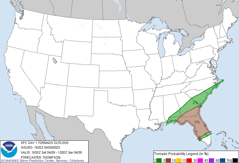
Cape Coral, FL...Port St. Lucie, FL...Charleston, SC...Macon, GA...Wilmington, NC...
Probabilistic Damaging Wind Graphic
Probability of damaging thunderstorm winds or wind gusts of 50 knots or higher within 25 miles of a point. Hatched Area: 10% of greater probability of wind gusts 65 knots or greater within 25 miles of a point.
New Orleans, LA...Miami, FL...Hialeah, FL...Montgomery, AL...Mobile, AL...
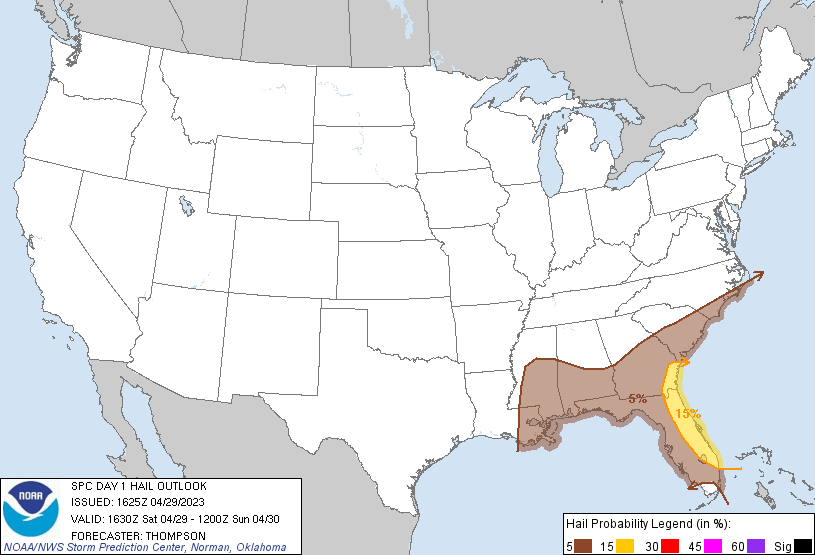
Probabilistic Large Hail Graphic
Probability of hail 1" or larger within 25 miles of a point. Hatched Area: 10% or greater probability of hail 2" or larger within 25 miles of a point.
Day 1 Hail Risk
Area (sq. mi.)
Area Pop.
Some Larger Population Centers in Risk Area
15 %
23,131
7,197,440
Jacksonville, FL...Orlando, FL...Savannah, GA...Port St. Lucie, FL...West Palm Beach, FL...
5 %
167,629
22,489,806
New Orleans, LA...Miami, FL...Tampa, FL...St. Petersburg, FL...Hialeah, FL...
SPC AC 291625
Day 1 Convective Outlook
NWS Storm Prediction Center Norman OK
1125 AM CDT Sat Apr 29 2023
Valid 291630Z - 301200Z
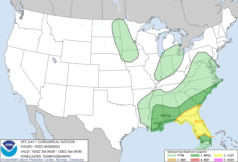
...THERE IS A SLIGHT RISK OF SEVERE THUNDERSTORMS THIS AFTERNOON
INTO TONIGHT ACROSS FL AND SOUTH GA...
...SUMMARY...
Two rounds of severe thunderstorms, with damaging winds, large hail,
and a coup[e of tornadoes, are possible across parts of Florida and
southern Georgia this afternoon, and again overnight.
...FL area through tonight...
A large cluster of thunderstorms over the northeast Gulf of Mexico
appears to be developing into an MCS, in advance of a pronounced
midlevel shortwave trough over the northwest Gulf coast. The
developing MCS is expected to progress east-northeastward over
central/north FL later this afternoon/evening, along and south of a
stalled front. Boundary-layer dewpoints near 70 F and surface
heating in cloud breaks will result in destabilization sufficient to
maintain the MCS and an attendant threat for damaging winds late
this afternoon. Aside from the MCS, cyclogenesis appears likely
near the Southeast Atlantic coast along the stalled front by
tonight, as the Gulf of Mexico shortwave trough begins to phase with
a deep low over the Great Lakes.
There will be some threat for additional storm development overnight
in association with the primary Gulf of Mexico shortwave trough and
cold front, in the wake of the afternoon MCS. Wind profiles will
strengthen with time tonight with the approach of the shortwave
trough and cyclogenesis. However, the main concern overnight will
be any reductions in moisture/buoyancy by today's convection.
Other storms may form this afternoon along the Atlantic coast sea
breeze from southeast into east central FL. MLCAPE in excess of
2500 J/kg and effective bulk shear of 35-50 kt (driven by relatively
weak low-level flow and stronger flow aloft) will support the
potential for organized/supercell storms with the potential to
produce isolated large hail and damaging winds.
...Coastal Carolinas late this afternoon into tonight...
The surface warm/moist sector will remain near the Atlantic coast
this afternoon, and an isolated strong storm may form along the
boundary this afternoon in southern NC. By tonight, there will be a
gradual increase in vertical shear in response to cyclogenesis, as
well as the possibility of a remnant MCV emerging from the Gulf of
Mexico MCS. There will be a conditional threat for
organized/supercell storms, though the details of thunderstorm
coverage/evolution will depend on the future influence of the Gulf
of Mexico convection, which is still uncertain this far northeast.
..Thompson/Smith.. 04/29/2023
CLICK TO GET WUUS01 PTSDY1 PRODUCT
NOTE: THE NEXT DAY 1 OUTLOOK IS SCHEDULED BY 2000Z