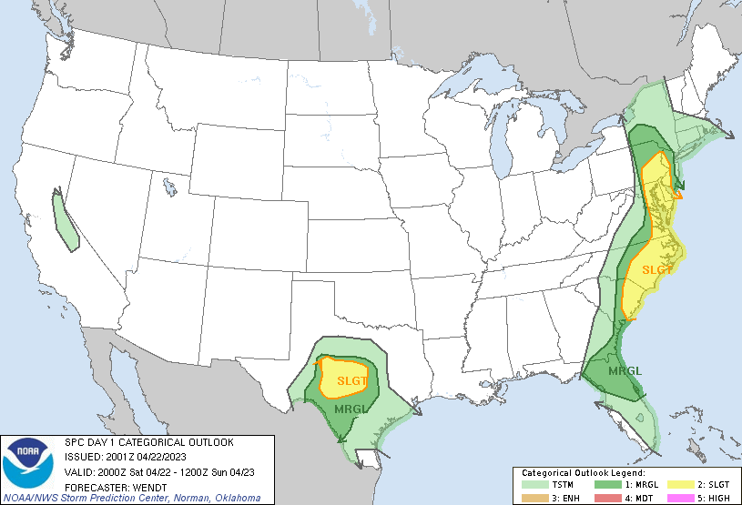
Philadelphia, PA...Baltimore, MD...Virginia Beach, VA...Raleigh, NC...Norfolk, VA...
MARGINAL
105,193
21,881,712
San Antonio, TX...Jacksonville, FL...Austin, TX...Washington, DC...Orlando, FL...
Probabilistic Tornado Graphic
Probability of a tornado within 25 miles of a point. Hatched Area: 10% or greater probability of EF2 - EF5 tornadoes within 25 miles of a point.
Day 1 Tornado Risk
Area (sq. mi.)
Area Pop.
Some Larger Population Centers in Risk Area
2 %
87,405
22,417,581
Philadelphia, PA...Baltimore, MD...Virginia Beach, VA...Raleigh, NC...Norfolk, VA...
Probabilistic Damaging Wind Graphic
Probability of damaging thunderstorm winds or wind gusts of 50 knots or higher within 25 miles of a point. Hatched Area: 10% of greater probability of wind gusts 65 knots or greater within 25 miles of a point.
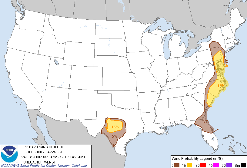
Day 1 Wind Risk
Area (sq. mi.)
Area Pop.
Some Larger Population Centers in Risk Area
15 %
91,965
21,037,044
Philadelphia, PA...Baltimore, MD...Virginia Beach, VA...Raleigh, NC...Norfolk, VA...
5 %
102,140
21,676,473
San Antonio, TX...Jacksonville, FL...Austin, TX...Washington, DC...Orlando, FL...
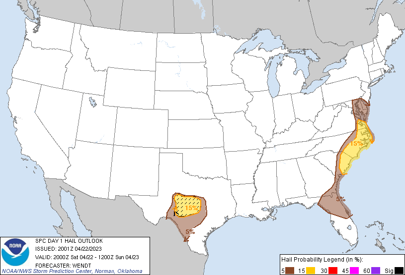
Probabilistic Large Hail Graphic
Probability of hail 1" or larger within 25 miles of a point. Hatched Area: 10% or greater probability of hail 2" or larger within 25 miles of a point.
Day 1 Hail Risk
Area (sq. mi.)
Area Pop.
Some Larger Population Centers in Risk Area
SIG SEVERE
23,437
421,280
San Angelo, TX...Copperas Cove, TX...Brownwood, TX...Fredericksburg, TX...
15 %
59,637
5,603,021
Virginia Beach, VA...Norfolk, VA...Chesapeake, VA...Newport News, VA...Hampton, VA...
5 %
90,307
17,111,048
San Antonio, TX...Jacksonville, FL...Austin, TX...Baltimore, MD...Raleigh, NC...
   SPC AC 222001

   Day 1 Convective Outlook
   NWS Storm Prediction Center Norman OK
   0301 PM CDT Sat Apr 22 2023

   Valid 222000Z - 231200Z

   ...THERE IS A SLIGHT RISK OF SEVERE THUNDERSTORMS PARTS OF THE
   MID-ATLANTIC AND TEXAS HILL COUNTRY...

   ...SUMMARY...
   Severe thunderstorms remain possible this afternoon over parts of
   the Carolinas into the Mid-Atlantic region, and this afternoon and
   evening over portions of south Texas.

   ...20Z Update...
   Minimal changes were made to the ongoing forecast. Across the
   Mid-Atlantic region, probabilities were remove behind earlier
   convection. For the Texas Hill Country, The Slight/Marginal areas
   were adjusted based on observations.

   ..Wendt.. 04/22/2023

   .PREV DISCUSSION... /ISSUED 1114 AM CDT Sat Apr 22 2023/

   ...Mid-Atlantic Region...
   The current water vapor loop shows a strong upper trough becoming
   negatively tilted over the Ohio Valley, with a 70-80 knot mid-level
   jet nosing into VA.  A persistent line of thunderstorms is tracking
   eastward into central VA/NC, and is expected to intensify soon.
   Thermodynamics ahead of the storms are rather weak, with limited
   lapse rates and MLCAPE generally below 500 J/kg.  However, given the
   strength of the winds aloft and approaching upper forcing, the
   potential for damaging wind gusts along the line is expected to
   increase.  These storms will track across eastern MD/DE before
   moving offshore by late afternoon.

   ...Carolinas...
   The primary cold front extends across western SC.  Strong heating is
   occurring ahead of the front over SC and parts of southern NC, where
   afternoon MLCAPE will rise to 1000-1500 J/kg.  Present indications
   are that storms will intensify in this area by mid-afternoon, with a
   combination of multicell and supercell structures possible.  Winds
   aloft are slightly weaker here than farther north, but still
   sufficient for a risk of hail and gusty/damaging winds in the
   stronger storms through the early evening.

   ...Hill Country of Texas...
   Latest surface analysis shows a weak low to the northwest of San
   Angelo, with a dryline extending southward to the Mexican border.
   Strong heating through the day will lead to a weak cap and 2000+
   J/kg of MLCAPE by mid/late afternoon. Isolated supercell storms are
   expected to form near the low and track slowly southeastward into
   the warm sector.  Forecast soundings show moderately steep mid level
   lapse rates and favorable deep layer shear for the risk of large
   hail and damaging wind gusts.  A tornado or two are possible, but
   limited low-level shear is expected to lessen that threat.

   CLICK TO GET WUUS01 PTSDY1 PRODUCT

   NOTE: THE NEXT DAY 1 OUTLOOK IS SCHEDULED BY 0100Z