Milwaukee, WI...Kansas City, MO...Atlanta, GA...Cincinnati, OH...Fort Wayne, IN...
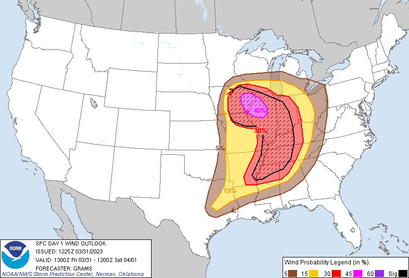
Probabilistic Damaging Wind Graphic
Probability of damaging thunderstorm winds or wind gusts of 50 knots or higher within 25 miles of a point. Hatched Area: 10% of greater probability of wind gusts 65 knots or greater within 25 miles of a point.
   SPC AC 311225

   Day 1 Convective Outlook
   NWS Storm Prediction Center Norman OK
   0725 AM CDT Fri Mar 31 2023

   Valid 311300Z - 011200Z

   ...THERE IS A MODERATE RISK OF SEVERE THUNDERSTORMS EASTERN PARTS OF
   IOWA/MISSOURI/ARKANSAS...ILLINOIS...WESTERN PARTS OF
   KENTUCKY/TENNESSEE...AND NORTHERN MISSISSIPPI...

   ...SUMMARY...
   A severe weather outbreak appears increasingly likely, centered on
   this afternoon and evening, across a large portion of the
   Mississippi Valley. At least a few long-track, strong to potentially
   violent tornadoes are probable, particularly over portions of the
   Mid-Mississippi Valley to the Mid-South. Swaths of intense damaging
   wind gusts along with very large hail are expected as well.

   ...Synopsis...
   A dangerous severe weather episode appears probable across a large
   portion of the central states this afternoon into tonight. Primary
   change with this outlook is to combine the Moderate Risks together
   given the possibility of long-track, strong to potentially violent
   tornadoes across a broad region of the MS Valley.

   ...Midwest and the Mid-MS to OH Valleys...
   A 992-mb cyclone over eastern NE will deepen through this afternoon
   as it matures into the Upper MS Valley before occluding this
   evening. A plume of surface-based buoyancy supported by mid 50s to
   60s dew points across the Mid-MO Valley to the southern Great Plains
   will shift east into the Mid to Lower MS Valleys through the day.
   Guidance is fairly consistent that initially elevated convection
   should increase in the Ozarks vicinity by late morning along the
   eastern gradient of the deeper buoyancy plume as a lobe of low-level
   ascent spreads northeast downstream of the vigorous central to
   southern High Plains shortwave trough. While this lead activity will
   have at least a large hail threat, how the other hazards evolve
   downstream into the afternoon across the MS River into IL is quite
   uncertain given large spread in guidance with overall
   coverage/intensity, along with pronounced differences in how quickly
   surface-based destabilization occurs to the east.

   The primary severe evolution remains likely to evolve beginning
   around 19Z to the southeast of the deep cyclone across central IA
   and broadening in coverage through the late afternoon along the
   north/south-oriented cold front arcing southward into eastern MO.
   Very steep mid-level lapse rates and an elongated mid to upper-level
   hodograph will initially support a broken band of supercells capable
   of producing very large hail. As activity rapidly spreads into an
   increasingly favorable low-level SRH environment in eastern IA and
   the MS Valley, several tornadoes are expected to form, a few of
   which could be strong and long-tracked.

   There should be an adequate gap between the lead and primary rounds
   of convection to support scattered supercells through at least
   east-central MO into most of IL into early evening. Within a 3-6 STP
   environment and the core of the 500-700 mb jets upstream there will
   be a threat for a couple, long-tracked supercells capable of
   producing strong to potentially violent tornadoes.

   All areas from north to south should consolidate into fast-moving
   line segments with primary threats of tornadoes and significant
   severe damaging wind swaths over the Midwest and Lower OH Valleys.
   Later tonight, QLCSs will outpace weakening surface-based
   instability around the central OH Valley. But the extreme low-level
   wind fields could support a waning wind/brief tornado threat
   approaching the central Appalachians.

   ...Ark-La-Tex to the Lower MS/TN Valleys...
   Multiple rounds of severe convection are expected to unfold,
   intensifying this afternoon in AR and Ark-La-Tex, before continuing
   east across the Lower MS into the TN Valleys through tonight.

   60s surface dew points will expand east beneath the southern extent
   of the extensive EML plume over the central states. This will
   support a broadening swath of moderate buoyancy characterized by
   MLCAPE of 1000-2000 J/kg. Strong low-level to deep-layer shear will
   promote pre-frontal supercells by afternoon. The more intense
   tornado threat should be during the late afternoon and evening
   across the Lower MS Valley and Mid-South owing to the peak
   combination of instability and classic, sickle-shaped hodographs.
   Strong to potentially violent tornadoes will be possible with a few
   long-tracked supercells.

   Upscale growth into a QLCS with embedded supercells appears probable
   during the late evening and overnight as frontal convergence
   strengthens. Tornadoes and significant damaging wind swaths will
   remain possible well into the night across at least the TN Valley,
   until warm-sector low-level flow becomes more veered towards the end
   of the period.

   ..Grams/Goss.. 03/31/2023

   CLICK TO GET WUUS01 PTSDY1 PRODUCT

   NOTE: THE NEXT DAY 1 OUTLOOK IS SCHEDULED BY 1630Z