Kansas City, MO...Wichita, KS...Corpus Christi, TX...Laredo, TX...Brownsville, TX...
SPC AC 021914
Day 3 Convective Outlook AMEND 1
NWS Storm Prediction Center Norman OK
0214 PM CDT Wed Nov 02 2022
Valid 041200Z - 051200Z
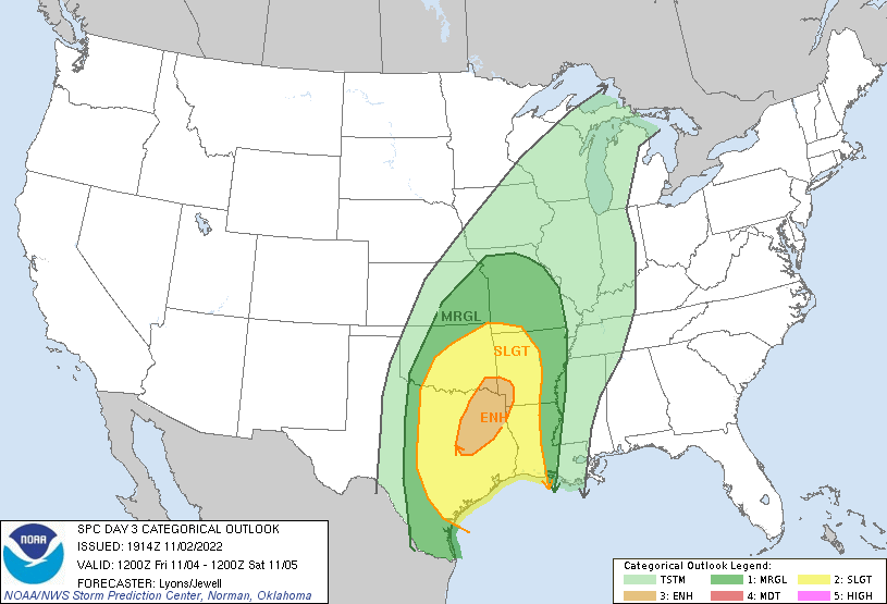
...THERE IS AN ENHANCED RISK OF SEVERE THUNDERSTORMS ACROSS PORTIONS
OF NORTHEAST TEXAS...SOUTHEAST OKLAHOMA AND FAR WESTERN
ARKANSAS/LOUISIANA...
AMENDED FOR HIGHER SEVERE PROBABILITIES AND EASTWARD SHIFT.
...SUMMARY...
Strong to severe thunderstorms are expected on Friday into Friday
night across portions of the southern and central Plains into
portions of the ArklaTex. Scattered damaging gusts, hail and a few
tornadoes will be possible.
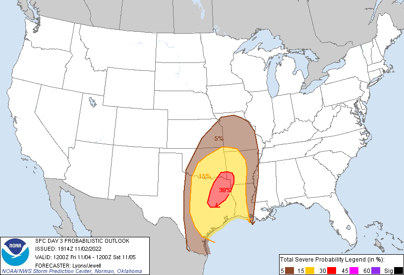
...19z Update...
Confidence has increased that the large-scale upper trough will
eject eastward faster than previous forecast guidance suggested. As
the upper trough is forecast to continue to intensify, increasingly
robust low and mid-level wind fields are expected to overspread a
destabilizing warm sector across much of central and northeast TX.
The northeastern extent of the larger buoyancy is still somewhat
uncertain, but strong forcing for ascent will likely support
numerous thunderstorms with a risk for damaging wind gusts across
portions of eastern OK, western AR and far southern MO. Confidence
is highest that a strongly forced QLCS will move eastward near the
cold front from early afternoon, and towards the Mississippi River
Valley overnight. A 50+ kt low-level jet and large looping
hodographs will favor damaging wind/mesovortex potential with the
QLCS. The tornado threat remains less certain and is tied to the
conditional risk for warm sector supercells ahead of the line, along
with the magnitude of destabilization, and open warm-sector forcing.
However, large 0-1km SRH (250+ m2/s2) and the potential for
supercells does suggest a conditional risk for tornadoes (possibly
significant). An Enhanced risk for mainly strong damaging wind gusts
has been added for storms late Friday through early Saturday
morning. The Slight Risk has also been expanded east for greater
severe potential through the overnight hours with the QLCS.
---Previous Discussion 0723Z---
...Southern/Central Plains and Vicinity...
Some forecast guidance has trended faster/more progressive with the
northeastward ejection of a large-scale upper trough oriented from
the northern Plains to the southern Rockies Friday morning. This
trough will lift northeast across the Plains toward the MS Valley by
Saturday morning, with a band of strong southwesterly deep-layer
flow overspreading the region.
Convection is expected to be ongoing at the beginning of the period
along a cold front oriented from the Upper MS Valley to central KS
and northwest TX. A 40-55 kt south/southwesterly low-level jet will
support continued strong warm advection ahead of the front. Mid to
upper 60s F boundary-layer dewpoints are expected as far north as
northeast OK, diminishing with northeast extent into the Upper
Midwest. Upper 60s to near 70 F boundary-layer dewpoints are
expected across parts of southern/central and eastern TX. This
seasonably moist air mass amid strong vertical shear will support
organized severe thunderstorms near the eastward surging surface
front.
Strong to severe storms may be ongoing at the beginning of the
period from central KS into western OK/northwest TX. Severe
potential will increase markedly with eastward extent, especially
across TX where stronger thermodynamics will align with favorable
shear. A linear storm mode appears most likely at this time, but a
few semi-discrete supercells also will be possible ahead of the
front across the warm sector. All severe hazards appear possible,
though damaging gusts and a few tornadoes will be the main concerns
through Friday night. The eastward extent of the severe threat is a
bit uncertain given differences in timing of the front and how far
east modest destabilization occurs. Some eastward adjustment to the
Slight and Marginal risk areas may be needed in subsequent outlooks.
..Lyons/Jewell.. 11/02/2022
CLICK TO GET WUUS03 PTSDY3 PRODUCT
NOTE: THE NEXT DAY 3 OUTLOOK IS SCHEDULED BY 0730Z