Austin, TX...Fort Worth, TX...Arlington, TX...Little Rock, AR...Killeen, TX...
2 %
141,986
15,151,980
Houston, TX...San Antonio, TX...Oklahoma City, OK...Kansas City, MO...Tulsa, OK...
Probabilistic Damaging Wind Graphic
Probability of damaging thunderstorm winds or wind gusts of 50 knots or higher within 25 miles of a point. Hatched Area: 10% of greater probability of wind gusts 65 knots or greater within 25 miles of a point.
Oklahoma City, OK...Kansas City, MO...Tulsa, OK...Wichita, KS...Corpus Christi, TX...
SPC AC 031729
Day 2 Convective Outlook
NWS Storm Prediction Center Norman OK
1229 PM CDT Thu Nov 03 2022
Valid 041200Z - 051200Z
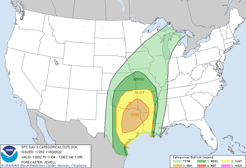
...THERE IS AN ENHANCED RISK OF SEVERE THUNDERSTORMS OVER MUCH OF
EASTERN/NORTHEASTERN TEXAS...SOUTHEAST OKLAHOMA...SOUTHWEST
ARKANSAS...AND NORTHERN LOUISIANA...
...SUMMARY...
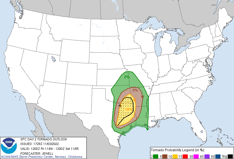
Severe thunderstorms are likely Friday into Friday night centered
over parts of northern and eastern Texas, eastern Oklahoma,
southwest Arkansas and western Louisiana. Several tornadoes are
possible over Texas with damaging winds spreading into Arkansas and
Louisiana overnight. A strong tornado or two may occur from late
afternoon into early evening.
...Synopsis...
An upper trough over NM will deepen and pivot northeastward across
northern TX, OK and KS during the day, then toward the mid MS Valley
by 12Z Saturday. Coincident with this wave will be a strengthening
mid and upper-level speed max with strong cooling aloft from the TX
Panhandle into KS.
At the surface, a cold front should extend roughly from eastern IA
into southeast KS and to a low over southwest OK at 12Z Friday, with
gradual deepening of the surface trough from MO into northeast TX
through 00Z. Southerly surface winds ahead of the cold front as well
as a broad zone of 40-50 kt southwesterly 850 mb winds will aid
moisture advection, with 68-72 F dewpoints south of the Red River,
and low 60s F into southern MO. The end result will be a region of
favorable instability, shear and lift from eastern TX and OK into
western AR and LA, with a threat of several tornadoes and damaging
winds.
...TX...OK...AR...LA...
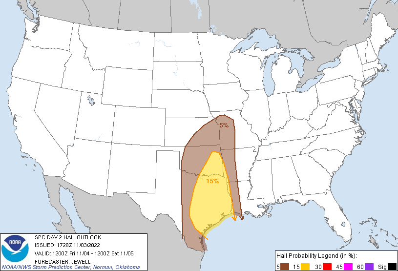
Scattered storms are expected to be ongoing near and north of a cold
front from northwest OK into eastern KS, with strong deep-layer
shear and cold temperatures aloft favoring hail. Given the
front-parallel nature to the winds aloft, these storms may become
elevated as the front undercuts the convection. Isolated damaging
gusts could occur immediately along the boundary.
To the south, moisture and instability will increase throughout the
day ahead of the cold front in TX. As pressures fall, boundary-layer
winds will become increasingly confluent along the I-35 corridor,
with deepening moist profiles. Forecast soundings indicate that the
capping inversion will not be very strong. As a result, increasing
large-scale lift will likely lead to pre-frontal storms after 19-20Z
over much of northern TX into southeast OK. Strong deep-layer shear
and MLCAPE of 1500-2000 J/kg will favor discrete cells, a few of
which may mature into tornadic supercells as SRH increases to around
300 m2/s2 by 00Z. Other isolated supercells are possible farther
southwestward into central TX as the cold front approaches the
instability axis. Low-level shear will not be as strong farther
south, but supercells will still be possible, including the threat
of locally damaging hail.
During the evening and overnight, the cold front will merge with any
existing warm sector activity, with a severe squall line forecast.
Damaging winds and brief tornadoes will be possible over eastern TX,
western LA and AR, and eastern OK. Other severe storms may occur
from northern AR into southern MO, where shear will be very strong,
but instability minimal. Sporadic wind damage may occur overnight in
these areas.
..Jewell.. 11/03/2022
CLICK TO GET WUUS02 PTSDY2 PRODUCT
NOTE: THE NEXT DAY 2 OUTLOOK IS SCHEDULED BY 0600Z