Probability of damaging thunderstorm winds or wind gusts of 50 knots or higher within 25 miles of a point. Hatched Area: 10% of greater probability of wind gusts 65 knots or greater within 25 miles of a point.
SPC AC 021723
Day 2 Convective Outlook
NWS Storm Prediction Center Norman OK
1223 PM CDT Mon May 02 2022
Valid 031200Z - 041200Z
...THERE IS A SLIGHT RISK OF SEVERE THUNDERSTORMS FROM PARTS OF
KENTUCKY NORTHEASTWARD INTO WESTERN PENNSYLVANIA...
...SUMMARY...
A severe threat will be possible Tuesday mainly from Kentucky across
Ohio and into western Pennsylvania. A few strong storms are also
expected from southern Virginia into northern North Carolina.
...Synopsis...
On Tuesday, a shortwave trough will move quickly across the OH
Valley and into the Northeast, with midlevel winds increasing to
40-50 kt with gradual height falls. Meanwhile, low pressure will
move from IN into OH during the afternoon, and across western NY
overnight. A front will extend west/southwest from the low, and move
very slowly across the OH Valley. Ahead of the cold front, a plume
of 60s F dewpoints will stream northeast out of TN and KY across OH
and into western PA, contributing to destabilization.
East of the Appalachians, a weak warm front will lift north across
northern NC and into VA, with 60s F dewpoints and heating resulting
in an unstable air mass.
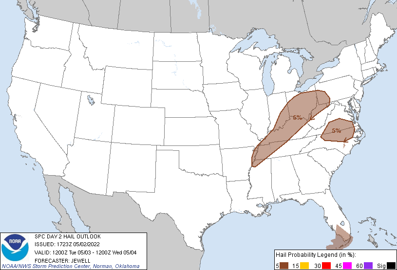
...OH Valley into western PA...
Elevated storms are likely Tuesday morning across parts of IN and OH
in the warm advection regime, but heating will occur behind this
activity resulting in MUCAPE around 1000-1500 J/kg. Additional
storms are likely to form along the front across IN and KY, with
other storms possibly forming farther east from OH into western PA
where low-level warm advection will remain into the afternoon.
Deep-layer shear will favor both hail and wind, but increased SRH
from eastern OH into PA and WV may yield a few supercells,
conditional on the surface-based air mass being uncapped near the
warm front. As a result, have expanded the Slight Risk area
northeastward into western PA.
...Southern VA into northern NC...
Strong heating will occur as a warm front lifts north, with MUCAPE
over 1500 J/kg likely by peak heating. Storms may initiate over the
higher terrain from western VA into NC, and across the warm sector
over central/northern NC where heating will be strong and the air
mass uncapped. Gusty outflow winds will be the primary threat as
cluster of storms propagate eastward into southern VA, but the
strongest storms may briefly produce marginal hail as well.
..Jewell.. 05/02/2022
CLICK TO GET WUUS02 PTSDY2 PRODUCT
NOTE: THE NEXT DAY 2 OUTLOOK IS SCHEDULED BY 0600Z