Probability of damaging thunderstorm winds or wind gusts of 50 knots or higher within 25 miles of a point. Hatched Area: 10% of greater probability of wind gusts 65 knots or greater within 25 miles of a point.
Day 1 Wind Risk
Area (sq. mi.)
Area Pop.
Some Larger Population Centers in Risk Area
15 %
110,068
9,194,793
New Orleans, LA...Baton Rouge, LA...Montgomery, AL...Mobile, AL...Columbus, GA...
Probability of hail 1" or larger within 25 miles of a point. Hatched Area: 10% or greater probability of hail 2" or larger within 25 miles of a point.
Day 1 Hail Risk
Area (sq. mi.)
Area Pop.
Some Larger Population Centers in Risk Area
5 %
75,987
6,594,479
New Orleans, LA...Baton Rouge, LA...Mobile, AL...Metairie, LA...Lafayette, LA...
SPC AC 140520
Day 1 Convective Outlook
NWS Storm Prediction Center Norman OK
1120 PM CST Tue Dec 13 2022
Valid 141200Z - 151200Z
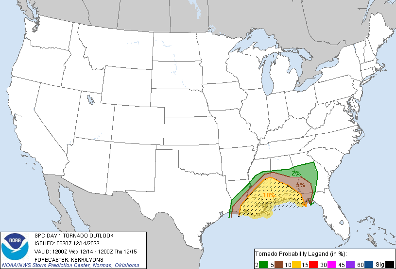
...THERE IS AN ENHANCED RISK OF SEVERE THUNDERSTORMS TODAY INTO
TONIGHT ACROSS PARTS OF SOUTHERN AND EASTERN LOUISIANA AND
MISSISSIPPI...SOUTHWESTERN ALABAMA AND MUCH OF THE FLORIDA
PANHANDLE...
...SUMMARY...
Severe thunderstorms are expected to develop across parts of the
central and eastern Gulf Coast states today through tonight. Some
will become capable of producing locally damaging wind gusts and
tornadoes, a few of which could be strong.
...Synopsis...
It appears that blocking will become a bit more prominent within the
westerlies across the mid-latitude eastern Pacific through the
western Atlantic during this period, with mid-level highs forecast
to continue to build offshore of the British Columbia coast and
across the northern Quebec vicinity. Several mid-level lows will
linger at slightly lower latitudes, including one which may continue
to deepen across the middle Missouri Valley vicinity, within larger
scale cyclonic flow encompassing much of the interior U.S.
An occluding surface cyclone may slowly weaken beneath the mid-level
low, which may only very slowly shift eastward today through
tonight. It appears that this will mostly be in response to a
vigorous short wave perturbation rapidly pivoting around its
southern and eastern periphery, from west Texas through the Upper
Midwest/Great Lakes vicinity. Models suggest that this will be
accompanied by secondary cyclogenesis along a lead surface front
advancing east of the lower Mississippi Valley by midday. The
surface low is generally forecast to track from central Mississippi
northward through the Ohio Valley, with a more significant cold
front overtaking the weaker lead front in its wake.
Additional cyclogenesis may initiate across the Piedmont of Alabama
into Georgia late this evening into the overnight hours. It appears
that this will be focused near the intersection of the eastward
advancing cold front and a developing warm front, as a wedge of
potentially cold air boundary-layer air over the Southeast gradually
erodes from the southwest. The cool, dry air is still expected to
be entrenched across much of Georgia, northern Florida and Alabama
into eastern Mississippi at 12Z this morning. However, beneath a
strengthening southerly low-level jet (including 40-50+ kt around
850 mb) off the northern Gulf of Mexico, substantive northeastward
boundary-layer moistening appears possible in a narrow pre-frontal
plume across southeastern Mississippi, toward west central Alabama,
by this afternoon, and perhaps across the Florida Panhandle toward
the Georgia Piedmont tonight.
...Lower Mississippi Valley/Eastern Gulf Coast states...
Aided by at least the glancing influence of the short wave impulse
emerging from west Texas, thunderstorm development, which probably
will be ongoing at 12Z this morning across the northwest Gulf Coast
and lower Mississippi Valley vicinity, is expected to persist and
perhaps increase through midday. This likely will include both
along the initially slow moving lead cold front, from northern
Mississippi into southwestern Louisiana coastal areas, and ahead of
the front near the intensifying low-level jet axis.
Clockwise-curved low-level hodographs conducive to tornadic
development probably will be maximized within the unstable
boundary-layer air across parts of southeastern Louisiana through
the Hattiesburg and Meridian vicinities of southeastern Mississippi
by mid to late afternoon. This is where potential for a couple of
longer-lived/longer track supercells currently appears greatest,
accompanied by the potential to produce a strong tornado or two,
before gradually spreading eastward into portions of southern
Alabama.
Upstream, along the cold front, which may begin to surge east of the
lower Mississippi Valley by this afternoon, a more widespread
line/cluster of thunderstorms may gradually evolve. However,
tornadic and damaging wind potential with this activity is more
uncertain, as forecast soundings suggest that this convection may
tend to be increasingly undercut by cold surface-based air.
Farther east, across the Florida Panhandle, northward into the
Georgia Piedmont, strengthening wind fields/shear and large-scale
forcing for ascent may maintain convection with potential to produce
locally damaging wind gusts and tornadoes late this evening into the
overnight hours. The extent of this potential will hinge on the
degree of northeastward boundary-layer destabilization, which
remains unclear at this time.
..Kerr/Lyons.. 12/14/2022
CLICK TO GET WUUS01 PTSDY1 PRODUCT
NOTE: THE NEXT DAY 1 OUTLOOK IS SCHEDULED BY 1300Z